Enable Location

We need your location to show you interesting places around you

Discover nearby places

Find interesting locations and hidden gems around you

Precise directions

Get accurate directions and distances to places

Your location is never shared with other users. It's only used when you tap the location button.

Cana Island

Log in to your account

Start exploring — it's free

Trusted by 62,997 travelers worldwide

Continue with Google
Continue with Apple
or

We will send you a code to connect

By continuing, you accept our Terms and Conditions and our Privacy Policy

Check your inbox

We've sent a pincode in your inbox. Please enter the code below.

Cana Island
Discussion Reviews 1 Photos
8.3k Popularity

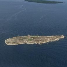
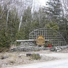
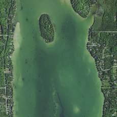
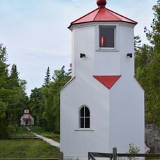
Cana Island, Navigation tower on Lake Michigan shore in Door County, US.

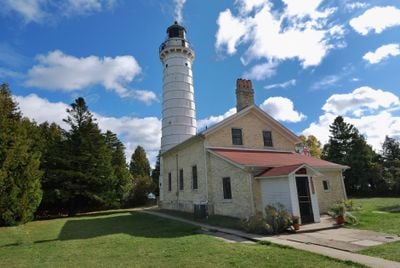
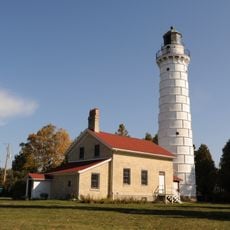
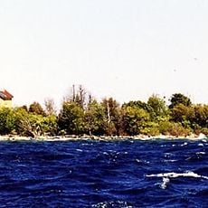
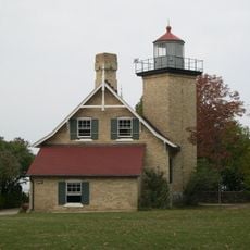
Cana Island Lighthouse is a white limestone tower with a red lantern room at its top, standing on a rocky island in Lake Michigan near Door County's shore. The structure rises distinctly from the water and connects to the mainland by a narrow causeway that visitors can cross on foot.

The lighthouse was built in 1869 to guide ships navigating the challenging waters of Lake Michigan. It became an essential aid for maritime traffic throughout the region's shipping era.

The keeper's house displays maritime objects, photographs, and documents that show how important shipping was to Door County's past. These items help visitors understand the connection between the local community and the lake.

You can reach the island by walking across the causeway or using a tractor-wagon service available from May through October. Plan your visit during the warmer months when access is most comfortable.

Inside the tower, a spiral staircase with 97 steps leads to an observation area at the top. From this vantage point, visitors can see across the water and surrounding landscape.

The community of curious travelers

AroundUs brings together thousands of curated places, local tips, and hidden gems, enriched daily by 60,000 contributors worldwide.

Start exploring
GPS coordinates
45.08842,-87.04949
Latest update
December 10, 2025 16:02
Around this place
Peninsula State Park
United States of America

Peninsula State Park

14.9 km
Whitefish Dunes State Park
United States of America

Whitefish Dunes State Park

22.3 km
Cana Island Light
United States of America

Cana Island Light

219 m
Newport State Park
United States of America

Newport State Park

16.9 km
Pilot Island
United States of America

Pilot Island

24.1 km
Baileys Harbor Range Lights
United States of America

Baileys Harbor Range Lights

5.9 km
The Clearing Folk School
United States of America

The Clearing Folk School

19.2 km
Pilot Island Light
United States of America

Pilot Island Light

24.1 km
The Ridges Sanctuary
United States of America

The Ridges Sanctuary

5.7 km
Eagle Bluff Light
United States of America

Eagle Bluff Light

17.2 km
United States of America

Mero Site

5.7 km
Gravel Island National Wildlife Refuge
United States of America

Gravel Island National Wildlife Refuge

14.1 km
Baileys Harbor Light
United States of America

Baileys Harbor Light

5.2 km
Alexander Noble House
United States of America

Alexander Noble House

16.1 km
Kangaroo Lake State Natural Area
United States of America

Kangaroo Lake State Natural Area

9.7 km
Church of the Atonement
United States of America

Church of the Atonement

16.3 km
Cupola House
United States of America

Cupola House

18.6 km
Ephraim Moravian Church
United States of America

Ephraim Moravian Church

11.9 km
Free Evangelical Lutheran Church-Bethania Scandinavian Evangelical Lutheran Congregation
United States of America

Free Evangelical Lutheran Church-Bethania Scandinavian Evangelical Lutheran Congregation

12 km
Gibraltar District School No. 2
United States of America

Gibraltar District School No. 2

12 km
Albert Zahn House
United States of America

Albert Zahn House

6.2 km
Freeman and Jesse Thorp House and Cottages
United States of America

Freeman and Jesse Thorp House and Cottages

15.9 km
Ephraim Village Hall
United States of America

Ephraim Village Hall

12.2 km
Peter Peterson House
United States of America

Peter Peterson House

12.2 km
Baileys Harbor Town Hall-McArdle Library
United States of America

Baileys Harbor Town Hall-McArdle Library

6.4 km
Baileys Harbor Range Rear Light
United States of America

Baileys Harbor Range Rear Light

6 km
Baileys Harbor Range Front Light
United States of America

Baileys Harbor Range Front Light

5.9 km
Cave Point County Park
United States of America

Cave Point County Park

20.2 km
Show the full map
Reviews
Share your experience

No review yet

Discussions
Start a discussion...

No discussion yet

« Cana Island - Navigation tower on Lake Michigan shore in Door County, US » is provided by Around Us (aroundus.com). Images and texts are derived from Wikimedia project under a Creative Commons license. You are allowed to copy, distribute, and modify copies of this page, under the conditions set by the license, as long as this note is clearly visible.

Discover hidden gems everywhere you go!

From secret cafés to breathtaking viewpoints, skip the crowded tourist spots and find places that match your style. Our app makes it easy with voice search, smart filtering, route optimization, and insider tips from travelers worldwide. Download now for the complete mobile experience.

Around Us App Screenshot

A unique approach to discovering new places

Le Figaro

All the places worth exploring

France Info

A tailor-made excursion in just a few clicks

20 Minutes

Around Us
Travel Guide & Maps
Download

Send to your phone

QR Code
1

Open the camera app on your mobile.

2

Point at the QR code with your camera. A notification will appear.

3

Tap the notification to open the link.