Pulpit Rocks

Log in to your account

AroundUs is a community-driven map of interesting places, built by curious explorers like you. It grows with every review, story, and photo you share.
Connect to save your favorite spots, contribute locations, and create personalized routes.
Continue with Google
Continue with Apple
Continue with X
Continue with Facebook
Continue with email
By continuing, you accept our Terms and Conditions and our Privacy Policy
Create an account
Add to collection
Map
Suggest a change
Share

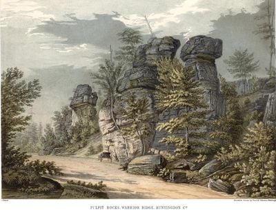
Pulpit Rocks, National Historic Landmark in Huntingdon County, Pennsylvania, United States

Pulpit Rocks are sandstone formations along Warrior Ridge that rise approximately 50 feet (15 meters) high and are separated by gaps wide enough to walk through. The structures display distinct layers of different rock types stacked vertically, creating a natural geological display.

These formations were studied by the Pennsylvania Geological Survey in the 1850s and provided crucial evidence for understanding how the Appalachian Mountains were structured in layers. The discovery of alternating rock types challenged existing scientific theories about mountain formation in North America.

Juniata College geology department conducts regular field studies at Pulpit Rocks, contributing to earth science education in Pennsylvania.

The site is accessible from Pike Road, located northwest of Huntingdon, and remains open throughout the year for visitors. The sandy and rocky ground can become slippery after rain, so sturdy footwear is recommended when navigating between the formations.

The rock formations display an unexpected pattern of alternating sandstone and other rock layers that surprised 19th-century scientists. This layering pattern was one of the first clear examples demonstrating the complex internal structure of the Appalachian Mountains.

Location: Huntingdon County

GPS coordinates: 40.51917,-78.04528

Latest update: December 14, 2025 15:01

Photos
Around this place
Raystown Lake
United States of America

Raystown Lake

10.1 km
Canoe Creek State Park
United States of America

Canoe Creek State Park

19.3 km
Tytoona Cave
United States of America

Tytoona Cave

16.6 km
Warrior Ridge Dam and Hydroelectric Plant
United States of America

Warrior Ridge Dam and Hydroelectric Plant

2.4 km
Spruce Creek Rod and Gun Club
United States of America

Spruce Creek Rod and Gun Club

17.3 km
Pennsylvania Railroad Old Bridge over Standing Stone Creek
United States of America

Pennsylvania Railroad Old Bridge over Standing Stone Creek

5.5 km
Huntingdon Borough Historic District
United States of America

Huntingdon Borough Historic District

4.7 km
Etna Furnace
United States of America

Etna Furnace

12 km
Williamsburg Historic District
United States of America

Williamsburg Historic District

14.9 km
Brumbaugh Homestead
United States of America

Brumbaugh Homestead

16.2 km
St. John's Evangelical Lutheran Church
United States of America

St. John's Evangelical Lutheran Church

19.2 km
Birmingham Bridge
United States of America

Birmingham Bridge

19.4 km
Corbin Bridge
United States of America

Corbin Bridge

8.9 km
H.O. Andrews Feed Mill
United States of America

H.O. Andrews Feed Mill

16.3 km
Huntingdon Armory
United States of America

Huntingdon Armory

5.8 km
Barree Forge and Furnace
United States of America

Barree Forge and Furnace

4.3 km
Mount Union Historic District
United States of America

Mount Union Historic District

18.7 km
Marklesburg Historic District
United States of America

Marklesburg Historic District

18.7 km
Pennsylvania Railroad District
United States of America

Pennsylvania Railroad District

13.8 km
Juniata Iron Works
United States of America

Juniata Iron Works

4.3 km
Jacob Isett House and Store
United States of America

Jacob Isett House and Store

16.6 km
Robb Farm
United States of America

Robb Farm

6.2 km
Pennsylvania Railroad Bridge over Shavers Creek
United States of America

Pennsylvania Railroad Bridge over Shavers Creek

5.3 km
Colerain Forges Mansion
United States of America

Colerain Forges Mansion

14.1 km
Lloyd and Henry Warehouse
United States of America

Lloyd and Henry Warehouse

4.3 km
Swigart Museum
United States of America

Swigart Museum

11.8 km
Huntingdon Furnace
United States of America

Huntingdon Furnace

16.6 km
Harpster Covered Bridge
United States of America

Harpster Covered Bridge

14.8 km
Show the full map
Reviews

Visited this place? Tap the stars to rate it and share your experience / photos with the community! Try now! You can cancel it anytime.

« Pulpit Rocks - National Historic Landmark in Huntingdon County, Pennsylvania, United States » is provided by Around Us (aroundus.com). Images and texts are derived from Wikimedia project under a Creative Commons license. You are allowed to copy, distribute, and modify copies of this page, under the conditions set by the license, as long as this note is clearly visible.

Discover hidden gems everywhere you go!

From secret cafés to breathtaking viewpoints, skip the crowded tourist spots and find places that match your style. Our app makes it easy with voice search, smart filtering, route optimization, and insider tips from travelers worldwide. Download now for the complete mobile experience.

Around Us App Screenshot

A unique approach to discovering new places

Le Figaro

All the places worth exploring

France Info

A tailor-made excursion in just a few clicks

20 Minutes