Enable Location

We need your location to show you interesting places around you

Discover nearby places

Find interesting locations and hidden gems around you

Precise directions

Get accurate directions and distances to places

Your location is never shared with other users. It's only used when you tap the location button.

Richard I. Bong Memorial Bridge

Log in to your account

Start exploring — it's free

Trusted by 61,931 travelers worldwide

Continue with Google
Continue with Apple
or

We will send you a code to connect

By continuing, you accept our Terms and Conditions and our Privacy Policy

Check your inbox

We've sent a pincode in your inbox. Please enter the code below.

Richard I. Bong Memorial Bridge

Richard I. Bong Memorial Bridge, Road bridge in Superior and Duluth, United States.

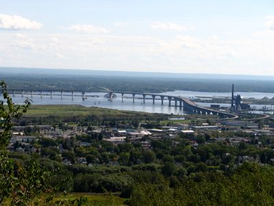
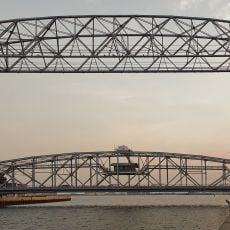
The Richard I. Bong Memorial Bridge is a road bridge that crosses the Saint Louis River, linking Superior, Wisconsin with Duluth, Minnesota. The structure features four traffic lanes and was built as a steel arch bridge with a suspended deck.

The bridge was built between 1979 and 1984, replacing the earlier wooden Arrowhead Bridge that previously connected these two cities. The new construction was needed to handle growing traffic demands.

The bridge carries the name of a World War II fighter pilot whose legacy remains known in the region, connecting his memory to the daily crossings of thousands of travelers. This naming reflects how the community chose to honor military service through infrastructure.

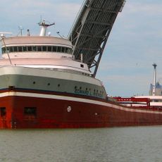
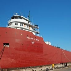
The crossing is well-maintained for vehicles of all sizes, and the wide navigation channel below allows large ships to pass through. Visitors can enjoy the view of the river and both shorelines from above, especially on clear days.

The steel used for the arch sections came from Japan, revealing how international materials became part of this American infrastructure project. This choice reflected practical and economic considerations of the construction period.

The community of curious travelers

AroundUs brings together thousands of curated places, local tips, and hidden gems, enriched daily by 60,000 contributors worldwide.

Start exploring
Location
Location
Official opening
October 25, 1985
GPS coordinates
46.73140,-92.14380
Latest update
December 8, 2025 19:54
Around this place
Aerial Lift Bridge
United States of America

Aerial Lift Bridge

6.6 km
STR Edward L Ryerson
United States of America

STR Edward L Ryerson

3.1 km
William A. Irvin
United States of America

William A. Irvin

6.7 km
SS Meteor
United States of America

SS Meteor

6.2 km
Enger Tower
United States of America

Enger Tower

5.2 km
Duluth Ship Canal
United States of America

Duluth Ship Canal

6.7 km
Lake Superior Railroad Museum
United States of America

Lake Superior Railroad Museum

6.3 km
Great Lakes Aquarium
United States of America

Great Lakes Aquarium

6.3 km
John A. Blatnik Bridge
United States of America

John A. Blatnik Bridge

3.8 km
Lake Superior Zoo
United States of America

Lake Superior Zoo

3.6 km
Lake Superior Maritime Visitor Center
United States of America

Lake Superior Maritime Visitor Center

6.6 km
Duluth Harbor North Pier Light
United States of America

Duluth Harbor North Pier Light

7 km
Cathedral of Christ the King
United States of America

Cathedral of Christ the King

4 km
Duluth South Breakwater Inner Light
United States of America

Duluth South Breakwater Inner Light

6.6 km
Duluth South Breakwater Outer Light
United States of America

Duluth South Breakwater Outer Light

6.9 km
Sacred Heart Cathedral, Sacred Heart School and Christian Brothers Home
United States of America

Sacred Heart Cathedral, Sacred Heart School and Christian Brothers Home

6.9 km
Duluth Civic Center Historic District
United States of America

Duluth Civic Center Historic District

6.4 km
Lincoln Branch Library
United States of America

Lincoln Branch Library

4.1 km
North Shore Scenic Railroad
United States of America

North Shore Scenic Railroad

6.4 km
Douglas County Courthouse
United States of America

Douglas County Courthouse

3.8 km
Irving School
United States of America

Irving School

1.9 km
YWCA of Duluth
United States of America

YWCA of Duluth

6.8 km
Empire Block
United States of America

Empire Block

3.2 km
Berkshire Block
United States of America

Berkshire Block

3.1 km
Richard I. Bong Veterans Historical Center
United States of America

Richard I. Bong Veterans Historical Center

5.8 km
William A Irvin Museum
United States of America

William A Irvin Museum

6.7 km
Fairlawn Mansion
United States of America

Fairlawn Mansion

6.4 km
Munger Terrace
United States of America

Munger Terrace

6.6 km
Show the full map
« Richard I. Bong Memorial Bridge - Road bridge in Superior and Duluth, United States » is provided by Around Us (aroundus.com). Images and texts are derived from Wikimedia project under a Creative Commons license. You are allowed to copy, distribute, and modify copies of this page, under the conditions set by the license, as long as this note is clearly visible.

Discover hidden gems everywhere you go!

From secret cafés to breathtaking viewpoints, skip the crowded tourist spots and find places that match your style. Our app makes it easy with voice search, smart filtering, route optimization, and insider tips from travelers worldwide. Download now for the complete mobile experience.

Around Us App Screenshot

A unique approach to discovering new places

Le Figaro

All the places worth exploring

France Info

A tailor-made excursion in just a few clicks

20 Minutes

Around Us
Travel Guide & Maps
Download

Send to your phone

QR Code
1

Open the camera app on your mobile.

2

Point at the QR code with your camera. A notification will appear.

3

Tap the notification to open the link.