Enable Location

We need your location to show you interesting places around you

Discover nearby places

Find interesting locations and hidden gems around you

Precise directions

Get accurate directions and distances to places

Your location is never shared with other users. It's only used when you tap the location button.

Shaeffer Campbell Covered Bridge

Log in to your account

Start exploring — it's free

Trusted by 61,878 travelers worldwide

Continue with Google
Continue with Apple
or

We will send you a code to connect

By continuing, you accept our Terms and Conditions and our Privacy Policy

Check your inbox

We've sent a pincode in your inbox. Please enter the code below.

Shaeffer Campbell Covered Bridge

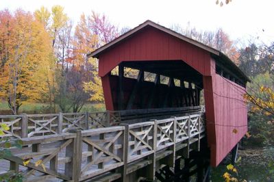
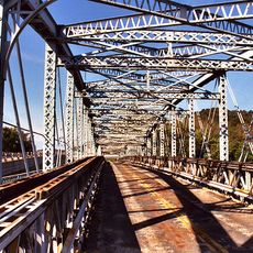
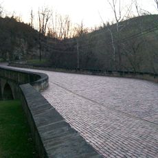
Shaeffer Campbell Covered Bridge, Covered road bridge in St. Clairsville, United States.

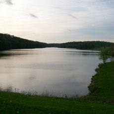
Shaeffer Campbell Covered Bridge is a timber-frame road crossing that spans College Pond on the Ohio University Eastern Campus. Angled front supports allow the roof to extend beyond the sides, creating an overhang that helps shed water.

The bridge was built in 1875 in Fairfield County and later relocated to Belmont County after damage at its original Clear Creek location. This move in the early 1970s saved the historical structure for the future.

The railings incorporate design elements from a famous American writer's home, connecting the structure to literary heritage through architectural craft.

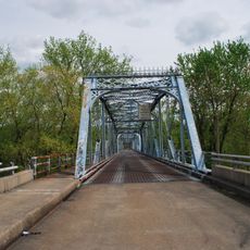
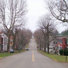
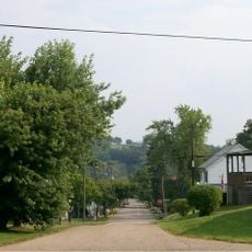
The bridge is open to pedestrians only and sits within easy walking distance on the Ohio University Eastern Campus. Note that it may occasionally close for local events like high school cross-country races held throughout the year.

The structure was originally built elsewhere and later moved to its present location on university grounds. This rescue and relocation makes it a rare example of successful preservation efforts for historical timber bridges.

The community of curious travelers

AroundUs brings together thousands of curated places, local tips, and hidden gems, enriched daily by 60,000 contributors worldwide.

Start exploring
Location
Inception
1875
GPS coordinates
40.07450,-80.97100
Latest update
December 14, 2025 18:15
Around this place
Wheeling Island
United States of America

Wheeling Island

20.3 km
Egypt Valley Wildlife Area
United States of America

Egypt Valley Wildlife Area

13.3 km
Dysart Woods
United States of America

Dysart Woods

10.3 km
Barkcamp State Park
United States of America

Barkcamp State Park

5.1 km
Bridgeport Bridge
United States of America

Bridgeport Bridge

19.8 km
Belmont County Courthouse
United States of America

Belmont County Courthouse

5.9 km
Aetnaville Bridge
United States of America

Aetnaville Bridge

20 km
Mount Pleasant Historic District
United States of America

Mount Pleasant Historic District

18.4 km
Friends Meetinghouse
United States of America

Friends Meetinghouse

18.1 km
Blaine Hill "S" Bridge
United States of America

Blaine Hill "S" Bridge

12.8 km
Belmont County Victorian Mansion Museum
United States of America

Belmont County Victorian Mansion Museum

19.9 km
Barnesville Historic District
United States of America

Barnesville Historic District

19.7 km
Concord Hicksite Friends Meeting House
United States of America

Concord Hicksite Friends Meeting House

16 km
Great Western Schoolhouse
United States of America

Great Western Schoolhouse

882 m
Benjamin Lundy House
United States of America

Benjamin Lundy House

18.1 km
Belleview Heights
United States of America

Belleview Heights

20.1 km
Opatrny Village Site
United States of America

Opatrny Village Site

2.4 km
Franklin College Building No. 5
United States of America

Franklin College Building No. 5

12.8 km
Rock Hill Presbyterian Church
United States of America

Rock Hill Presbyterian Church

17.4 km
James Kinney Farmstead
United States of America

James Kinney Farmstead

8.7 km
Joseph Kirkwood House
United States of America

Joseph Kirkwood House

19.3 km
St. Clairsville Public Library
United States of America

St. Clairsville Public Library

6 km
Morristown Historic District
United States of America

Morristown Historic District

8.7 km
St. Clairsville Historic District
United States of America

St. Clairsville Historic District

5.9 km
Belmont Historic District
United States of America

Belmont Historic District

7.9 km
Dr. Lindley Schooley House and Office
United States of America

Dr. Lindley Schooley House and Office

7.9 km
Thomas T. and Wesley B. Frasier Houses
United States of America

Thomas T. and Wesley B. Frasier Houses

18 km
Piedmont Lake
United States of America

Piedmont Lake

19.7 km
Show the full map
« Shaeffer Campbell Covered Bridge - Covered road bridge in St. Clairsville, United States » is provided by Around Us (aroundus.com). Images and texts are derived from Wikimedia project under a Creative Commons license. You are allowed to copy, distribute, and modify copies of this page, under the conditions set by the license, as long as this note is clearly visible.

Discover hidden gems everywhere you go!

From secret cafés to breathtaking viewpoints, skip the crowded tourist spots and find places that match your style. Our app makes it easy with voice search, smart filtering, route optimization, and insider tips from travelers worldwide. Download now for the complete mobile experience.

Around Us App Screenshot

A unique approach to discovering new places

Le Figaro

All the places worth exploring

France Info

A tailor-made excursion in just a few clicks

20 Minutes

Around Us
Travel Guide & Maps
Download

Send to your phone

QR Code
1

Open the camera app on your mobile.

2

Point at the QR code with your camera. A notification will appear.

3

Tap the notification to open the link.