Enable Location

We need your location to show you interesting places around you

Discover nearby places

Find interesting locations and hidden gems around you

Precise directions

Get accurate directions and distances to places

Your location is never shared with other users. It's only used when you tap the location button.

Smoky Hill Chalk Member

Log in to your account

Start exploring — it's free

Trusted by 65,437 travelers worldwide

Continue with Google
Continue with Apple
or

We will send you a code to connect

By continuing, you accept our Terms and Conditions and our Privacy Policy

Check your inbox

We've sent a pincode in your inbox. Please enter the code below.

Smoky Hill Chalk Member
Discussion Reviews 1 Photos
5.7k Popularity

Smoky Hill Chalk Member, Paleontological formation in Western Kansas and Colorado, United States.

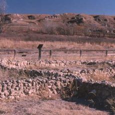
The Smoky Hill Chalk Member is a soft chalk formation found across parts of Colorado, Kansas, Nebraska, and South Dakota, made up of layers of marine shells and skeletal remains deposited on an ancient seafloor. The layers also contain bands of bentonite, jarosite, pyrite, and chert mixed in between the chalk.

Around 80 million years ago, a shallow inland sea called the Western Interior Seaway covered much of central North America, including this region. Over time, the remains of sea creatures sank to the bottom, slowly building up the chalk layers that are visible today.

The chalk outcrops draw fossil hunters and researchers who come looking for marine reptiles, fish, and birds from the age of dinosaurs. Finds from this area have ended up in museums across the United States and beyond.

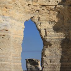
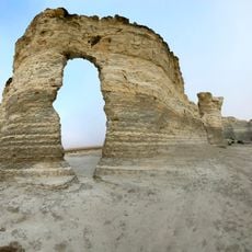
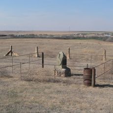
Monument Rocks and Castle Rock in Kansas are the easiest places to see the chalk cliffs up close, and visitors can walk right among the formations. Both spots are on open land with little shade, so visiting early in the day makes the experience more comfortable.

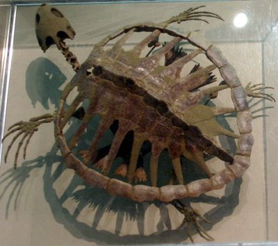
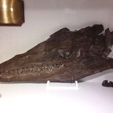
A Xiphactinus fossil was found with a fully intact Gillicus arcuatus still inside its body, a rare case where both predator and prey are preserved together. The prey fish was large enough that swallowing it apparently killed the predator.

The community of curious travelers

AroundUs brings together thousands of curated places, local tips, and hidden gems, enriched daily by 60,000 contributors worldwide.

Start exploring
Location
Location
Location
Location
Part of
Niobrara Formation
GPS coordinates
38.80250,-100.94250
Latest update
March 3, 2026 08:16
Around this place
Monument Rocks
United States of America

Monument Rocks

15.7 km
Little Jerusalem Badlands State Park
United States of America

Little Jerusalem Badlands State Park

0 m
Lake Scott State Park
United States of America

Lake Scott State Park

14.3 km
Cottonwood Ranch
United States of America

Cottonwood Ranch

90.6 km
English Lutheran Church
United States of America

English Lutheran Church

30.3 km
El Quartelejo Ruins
United States of America

El Quartelejo Ruins

14.1 km
Mary Seaman Ennis House
United States of America

Mary Seaman Ennis House

90 km
Grainfield Opera House
United States of America

Grainfield Opera House

53.8 km
Oakley High School Stadium
United States of America

Oakley High School Stadium

37.4 km
Pond Creek Station
United States of America

Pond Creek Station

56.8 km
Goodland City Library
United States of America

Goodland City Library

90 km
Thomas County Courthouse
United States of America

Thomas County Courthouse

66.6 km
Beamer Barn
United States of America

Beamer Barn

38.6 km
George Washington Carver Homestead Site
United States of America

George Washington Carver Homestead Site

77.5 km
Greeley County Courthouse
United States of America

Greeley County Courthouse

79.3 km
Clark–Robidoux House
United States of America

Clark–Robidoux House

57.9 km
Lane County Community High School
United States of America

Lane County Community High School

55.1 km
Shafer Barn
United States of America

Shafer Barn

78.7 km
Lipp Barn
United States of America

Lipp Barn

76.2 km
Alexander & Anna Schwartz Farm
United States of America

Alexander & Anna Schwartz Farm

70.3 km
William B. and Julia Washington House
United States of America

William B. and Julia Washington House

50.9 km
Oxley Barn
United States of America

Oxley Barn

69.7 km
Old Logan County Courthouse
United States of America

Old Logan County Courthouse

23.9 km
Bungalow Historic District
United States of America

Bungalow Historic District

92.5 km
Collyer Downtown Historic District
United States of America

Collyer Downtown Historic District

76.1 km
Fick Fossil and History Museum
United States of America

Fick Fossil and History Museum

36.9 km
World's Largest Easel
United States of America

World's Largest Easel

88.9 km
Giant van Gogh Painting
United States of America

Giant van Gogh Painting

88.8 km
Show the full map
Reviews
Share your experience

No review yet

Discussions
Start a discussion...

No discussion yet

« Smoky Hill Chalk Member - Paleontological formation in Western Kansas and Colorado, United States » is provided by Around Us (aroundus.com). Images and texts are derived from Wikimedia project under a Creative Commons license. You are allowed to copy, distribute, and modify copies of this page, under the conditions set by the license, as long as this note is clearly visible.

Discover hidden gems everywhere you go!

From secret cafés to breathtaking viewpoints, skip the crowded tourist spots and find places that match your style. Our app makes it easy with voice search, smart filtering, route optimization, and insider tips from travelers worldwide. Download now for the complete mobile experience.

Around Us App Screenshot

A unique approach to discovering new places

Le Figaro

All the places worth exploring

France Info

A tailor-made excursion in just a few clicks

20 Minutes

Around Us
Travel Guide & Maps
Download

Send to your phone

QR Code
1

Open the camera app on your mobile.

2

Point at the QR code with your camera. A notification will appear.

3

Tap the notification to open the link.