Enable Location

We need your location to show you interesting places around you

Discover nearby places

Find interesting locations and hidden gems around you

Precise directions

Get accurate directions and distances to places

Your location is never shared with other users. It's only used when you tap the location button.

Shadmoor State Park

Log in to your account

Start exploring — it's free

Trusted by 65,206 travelers worldwide

Continue with Google
Continue with Apple
or

We will send you a code to connect

By continuing, you accept our Terms and Conditions and our Privacy Policy

Check your inbox

We've sent a pincode in your inbox. Please enter the code below.

Shadmoor State Park
Discussion Reviews 1 Photos
4.5k Popularity

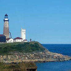
Shadmoor State Park, Coastal state park in Montauk, United States

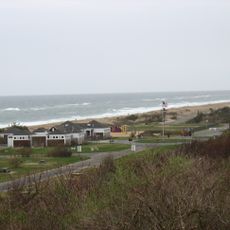
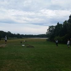
Shadmoor State Park is a coastal park on the south shore of Montauk, in Suffolk County, New York State. It combines direct beach access, open grasslands, walking trails, and raised observation decks that look out over the Atlantic Ocean.

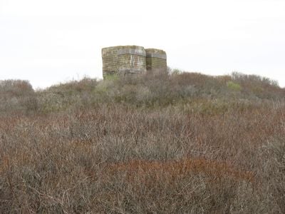
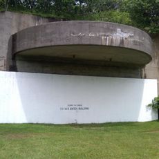
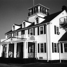
During World War II, the site was part of New York's coastal defense system, and two concrete bunkers built at that time are still standing today. The land was later protected as a state park to keep the shoreline from being developed.

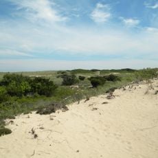
The shadbush plants that inspired the park's name still grow here and are easy to spot along the trails in spring. The open grasslands give the place a raw, windswept feel that sets it apart from the more developed stretches of Montauk nearby.

The park is open throughout the year and has free parking close to the entrance. Bring sturdy footwear and an extra layer, as the wind off the ocean can be strong even on clear days.

The sand plain gerardia, a federally listed endangered plant, grows in the park and exists in only a handful of places along the entire east coast. Most visitors walk right past it without knowing they are looking at one of the rarest wild plants in the region.

The community of curious travelers

AroundUs brings together thousands of curated places, local tips, and hidden gems, enriched daily by 60,000 contributors worldwide.

Start exploring
Location
GPS coordinates
41.03722,-71.92526
Latest update
March 3, 2026 08:12
Around this place
Camp Hero State Park
United States of America

Camp Hero State Park

5.8 km
Hither Hills State Park
United States of America

Hither Hills State Park

7.7 km
AN/FPS-35, Montauk, New York State
United States of America

AN/FPS-35, Montauk, New York State

5.1 km
Montauk Downs State Park
United States of America

Montauk Downs State Park

2 km
Pollock-Krasner House and Studio
United States of America

Pollock-Krasner House and Studio

19.4 km
Hook Windmill
United States of America

Hook Windmill

23.1 km
Montauk County Park
United States of America

Montauk County Park

3 km
Montauk Point Lighthouse
United States of America

Montauk Point Lighthouse

6.8 km
Amagansett National Wildlife Refuge
United States of America

Amagansett National Wildlife Refuge

18.5 km
Coast Guard Station Montauk
United States of America

Coast Guard Station Montauk

4 km
Mulford Farmhouse
United States of America

Mulford Farmhouse

24.1 km
Gardiners Island Windmill
United States of America

Gardiners Island Windmill

16.7 km
Hayground Windmill
United States of America

Hayground Windmill

22.2 km
Amelia Cottage Museum
United States of America

Amelia Cottage Museum

19.7 km
Pantigo Road Historic District
United States of America

Pantigo Road Historic District

22.6 km
Stephen Sherrill House
United States of America

Stephen Sherrill House

22.7 km
Saint Thomas' Chapel
United States of America

Saint Thomas' Chapel

19.7 km
Caleb Bragg Estate
United States of America

Caleb Bragg Estate

3.9 km
North Main Street Historic District
United States of America

North Main Street Historic District

23.2 km
Ambrose Parsons House
United States of America

Ambrose Parsons House

19.6 km
Montauk Point Light
United States of America

Montauk Point Light

6.8 km
Egypt Lane Historic District
United States of America

Egypt Lane Historic District

22.9 km
Pleasants House
United States of America

Pleasants House

19.3 km
Montauk Point State Park
United States of America

Montauk Point State Park

6.9 km
Napeague State Park
United States of America

Napeague State Park

13.8 km
Pollock-Krasner House
United States of America

Pollock-Krasner House

19.3 km
Montauk Association Historic District
United States of America

Montauk Association Historic District

1.7 km
Montauk Playhouse
United States of America

Montauk Playhouse

2.6 km
Show the full map
Reviews
Share your experience

No review yet

Discussions
Start a discussion...

No discussion yet

« Shadmoor State Park - Coastal state park in Montauk, United States » is provided by Around Us (aroundus.com). Images and texts are derived from Wikimedia project under a Creative Commons license. You are allowed to copy, distribute, and modify copies of this page, under the conditions set by the license, as long as this note is clearly visible.

Discover hidden gems everywhere you go!

From secret cafés to breathtaking viewpoints, skip the crowded tourist spots and find places that match your style. Our app makes it easy with voice search, smart filtering, route optimization, and insider tips from travelers worldwide. Download now for the complete mobile experience.

Around Us App Screenshot

A unique approach to discovering new places

Le Figaro

All the places worth exploring

France Info

A tailor-made excursion in just a few clicks

20 Minutes

Around Us
Travel Guide & Maps
Download

Send to your phone

QR Code
1

Open the camera app on your mobile.

2

Point at the QR code with your camera. A notification will appear.

3

Tap the notification to open the link.