Enable Location

We need your location to show you interesting places around you

Discover nearby places

Find interesting locations and hidden gems around you

Precise directions

Get accurate directions and distances to places

Your location is never shared with other users. It's only used when you tap the location button.

AN/FPS-35, Montauk, New York State

Log in to your account

Start exploring — it's free

Trusted by 63,013 travelers worldwide

Continue with Google
Continue with Apple
or

We will send you a code to connect

By continuing, you accept our Terms and Conditions and our Privacy Policy

Check your inbox

We've sent a pincode in your inbox. Please enter the code below.

Discussion Reviews 1 Photos
7.3k Popularity

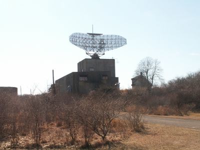
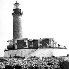
AN/FPS-35, Montauk, New York State, Air search radar station at Montauk, United States.

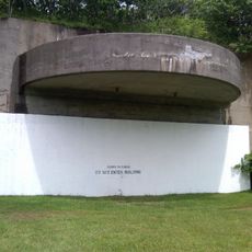
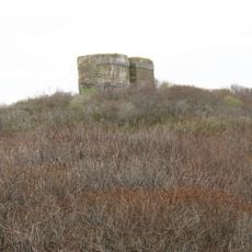
The AN/FPS-35 is a radar station in Camp Hero State Park with a massive antenna mounted on one of the world's largest rolling-element bearings. The tower stands about 150 feet (46 meters) high and is the only surviving installation of its kind with its original antenna intact.

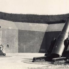
The radar station was built in 1960 to monitor aircraft and missiles along the eastern seaboard. It was part of the American defense system during the Cold War and played an important role in early warning against potential threats.

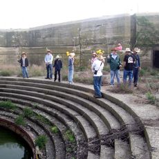
The radar station shows how military technology looked and worked during the 1960s. Visitors can see today how such facilities became part of daily coastal life.

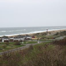
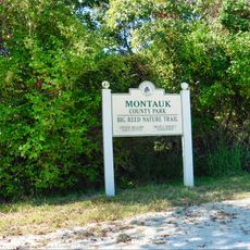
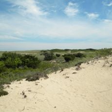
The radar station is located in Camp Hero State Park and is accessible to visitors. Wear good shoes since the coastal area can be windy and exposed to the elements.

Fishing boats in the area used the radar installation for years as a navigation reference point on the water. It was more reliable for navigation than the nearby lighthouse.

The community of curious travelers

AroundUs brings together thousands of curated places, local tips, and hidden gems, enriched daily by 60,000 contributors worldwide.

Start exploring
Location
Inception
1960
GPS coordinates
41.06245,-71.87451
Latest update
December 8, 2025 20:03
Around this place
Camp Hero State Park
United States of America

Camp Hero State Park

735 m
Hither Hills State Park
United States of America

Hither Hills State Park

12.8 km
Montauk Downs State Park
United States of America

Montauk Downs State Park

5.8 km
Race Rock Light
United States of America

Race Rock Light

24.8 km
Pollock-Krasner House and Studio
United States of America

Pollock-Krasner House and Studio

24 km
Montauk County Park
United States of America

Montauk County Park

2.3 km
Montauk Point Lighthouse
United States of America

Montauk Point Lighthouse

1.7 km
Shadmoor State Park
United States of America

Shadmoor State Park

5.1 km
Fort H. G. Wright
United States of America

Fort H. G. Wright

25 km
Fort Michie
United States of America

Fort Michie

25.6 km
Amagansett National Wildlife Refuge
United States of America

Amagansett National Wildlife Refuge

23.5 km
Watch Hill Light
United States of America

Watch Hill Light

26.9 km
Coast Guard Station Montauk
United States of America

Coast Guard Station Montauk

5.2 km
Gardiners Island Windmill
United States of America

Gardiners Island Windmill

20.1 km
Amelia Cottage Museum
United States of America

Amelia Cottage Museum

24.7 km
Saint Thomas' Chapel
United States of America

Saint Thomas' Chapel

24.7 km
Caleb Bragg Estate
United States of America

Caleb Bragg Estate

5.1 km
Ambrose Parsons House
United States of America

Ambrose Parsons House

24.2 km
Montauk Point Light
United States of America

Montauk Point Light

1.7 km
Pleasants House
United States of America

Pleasants House

24.3 km
Montauk Point State Park
United States of America

Montauk Point State Park

1.8 km
Napeague State Park
United States of America

Napeague State Park

18.8 km
Pollock-Krasner House
United States of America

Pollock-Krasner House

23.9 km
Little Gull Island Light
United States of America

Little Gull Island Light

25.2 km
Fishers Island Theatre
United States of America

Fishers Island Theatre

25.2 km
Montauk Association Historic District
United States of America

Montauk Association Historic District

3.4 km
Montauk Playhouse
United States of America

Montauk Playhouse

6.5 km
Fishers Island Library
United States of America

Fishers Island Library

25 km
Show the full map
Reviews
Share your experience

No review yet

Discussions
Start a discussion...

No discussion yet

« AN/FPS-35, Montauk, New York State - Air search radar station at Montauk, United States » is provided by Around Us (aroundus.com). Images and texts are derived from Wikimedia project under a Creative Commons license. You are allowed to copy, distribute, and modify copies of this page, under the conditions set by the license, as long as this note is clearly visible.

Discover hidden gems everywhere you go!

From secret cafés to breathtaking viewpoints, skip the crowded tourist spots and find places that match your style. Our app makes it easy with voice search, smart filtering, route optimization, and insider tips from travelers worldwide. Download now for the complete mobile experience.

Around Us App Screenshot

A unique approach to discovering new places

Le Figaro

All the places worth exploring

France Info

A tailor-made excursion in just a few clicks

20 Minutes

Around Us
Travel Guide & Maps
Download

Send to your phone

QR Code
1

Open the camera app on your mobile.

2

Point at the QR code with your camera. A notification will appear.

3

Tap the notification to open the link.