The Narrows

Log in to your account

AroundUs is a community-driven map of interesting places, built by curious explorers like you. It grows with every review, story, and photo you share.
Connect to save your favorite spots, contribute locations, and create personalized routes.
By continuing, you accept our Terms and Conditions and our Privacy Policy
Add to collection
Map
Suggest a change
Share

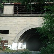
The Narrows, Water gap in Bedford County, United States

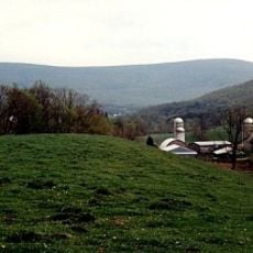
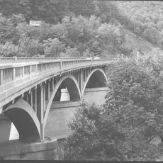
The Narrows is a water gap where the Raystown Branch of the Juniata River cuts through Evitts Mountain, creating a natural passage between rock walls. Two major highways follow this river corridor, taking advantage of the natural route through the mountainous terrain.

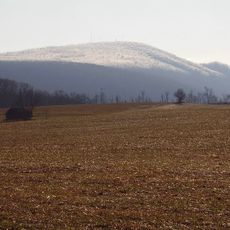
The rock formations visible here developed millions of years ago through massive folding and shifting of geological layers, which exposed different stone types. The river then carved its way through these layers, gradually widening the passage over millennia.

This passage has served as a major transportation corridor for people crossing the mountains for generations, shaping how the region connects its communities. The roads visible here remain central to how people move through the area today.

You can reach this area via the Pennsylvania Turnpike or U.S. Route 30, both of which provide good viewpoints from the road. The best time to observe the rock formations is during daylight with clear weather, as they are most visible from the roadside.

The roadcut for the turnpike exposed four distinct geological layers stacked on top of each other, offering a rare window into how the earth was built. These layers reveal how ancient rocks were folded and overturned, creating patterns visible to anyone traveling through the gap.

Location: Bedford County

GPS coordinates: 40.01500,-78.47280

Latest update: December 14, 2025 17:00

Photos
Around this place
Shawnee State Park
United States of America

Shawnee State Park

13.9 km
Buchanan State Forest
United States of America

Buchanan State Forest

21.4 km
Bedford Village Archeological Site
United States of America

Bedford Village Archeological Site

4.4 km
The Coffee Pot
United States of America

The Coffee Pot

3.9 km
Martin Hill
United States of America

Martin Hill

20.4 km
Espy House
United States of America

Espy House

2.6 km
Diehls Covered Bridge
United States of America

Diehls Covered Bridge

15 km
State Game Lands Number 49
United States of America

State Game Lands Number 49

22 km
Kinton Knob
United States of America

Kinton Knob

7 km
Barclay House
United States of America

Barclay House

2.7 km
Chestnut Ridge and Schellsburg Union Church and Cemetery
United States of America

Chestnut Ridge and Schellsburg Union Church and Cemetery

16 km
New Paris Covered Bridge
United States of America

New Paris Covered Bridge

19 km
Dr. Knisley Covered Bridge
United States of America

Dr. Knisley Covered Bridge

19.5 km
Jacksons Mill Covered Bridge
United States of America

Jacksons Mill Covered Bridge

17.8 km
Ryot Covered Bridge
United States of America

Ryot Covered Bridge

19.2 km
Halls Mill Covered Bridge
United States of America

Halls Mill Covered Bridge

18 km
Bridge in Snake Spring Township
United States of America

Bridge in Snake Spring Township

96 m
Bedford Historic District
United States of America

Bedford Historic District

2.1 km
Feltons Mill Covered Bridge
United States of America

Feltons Mill Covered Bridge

16.4 km
Everett Historic District
United States of America

Everett Historic District

8.6 km
Heirline Covered Bridge
United States of America

Heirline Covered Bridge

10.3 km
Russell House
United States of America

Russell House

2.7 km
Snooks Covered Bridge
United States of America

Snooks Covered Bridge

19.4 km
Osterburg Covered Bridge
United States of America

Osterburg Covered Bridge

19 km
Schellsburg Historic District
United States of America

Schellsburg Historic District

15 km
New Enterprise Public School
United States of America

New Enterprise Public School

18.3 km
Fort Bedford Museum
United States of America

Fort Bedford Museum

2.7 km
Juniata Woolen Mill and Newry Manor
United States of America

Juniata Woolen Mill and Newry Manor

3.6 km
Show the full map
Reviews

Visited this place? Tap the stars to rate it and share your experience / photos with the community! Try now! You can cancel it anytime.

« The Narrows - Water gap in Bedford County, United States » is provided by Around Us (aroundus.com). Images and texts are derived from Wikimedia project under a Creative Commons license. You are allowed to copy, distribute, and modify copies of this page, under the conditions set by the license, as long as this note is clearly visible.

Discover hidden gems everywhere you go!

From secret cafés to breathtaking viewpoints, skip the crowded tourist spots and find places that match your style. Our app makes it easy with voice search, smart filtering, route optimization, and insider tips from travelers worldwide. Download now for the complete mobile experience.

Around Us App Screenshot

A unique approach to discovering new places

Le Figaro

All the places worth exploring

France Info

A tailor-made excursion in just a few clicks

20 Minutes