Enable Location

We need your location to show you interesting places around you

Discover nearby places

Find interesting locations and hidden gems around you

Precise directions

Get accurate directions and distances to places

Your location is never shared with other users. It's only used when you tap the location button.

Washington Heights Historic District

Log in to your account

Start exploring — it's free

Trusted by 62,474 travelers worldwide

Continue with Google
Continue with Apple
or

We will send you a code to connect

By continuing, you accept our Terms and Conditions and our Privacy Policy

Check your inbox

We've sent a pincode in your inbox. Please enter the code below.

Washington Heights Historic District, Historic district in Adams Morgan, United States.

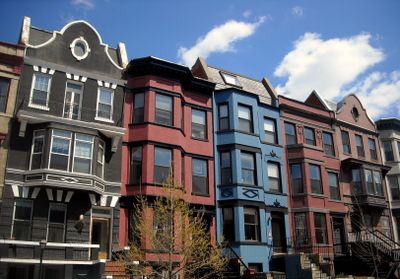
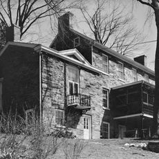
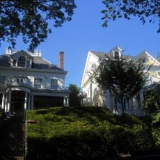
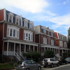
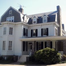
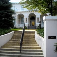
Washington Heights Historic District is a residential area in Adams Morgan containing 347 registered historic properties. These row houses and apartment buildings date from the late 1800s and early 1900s and line the neighborhood's grid-patterned streets.

The area began as a streetcar suburb in 1891 and grew into a mixed residential community by the middle of the 1900s. Middle-class families and immigrant populations settled here during this period, shaping the neighborhood's development.

The district reflects how diverse communities shaped Washington D.C.'s residential character, with buildings that show Colonial Revival and Craftsman influences from when it was developed. Walking through the streets, you notice how the architecture tells the story of middle-class families and immigrant groups who made this neighborhood their home.

The neighborhood is easily reached by public transportation, including bus lines and metro stations serving Adams Morgan. Plan to walk through the streets at a leisurely pace to notice the architectural details on each building.

Many buildings retain original architectural details such as decorative cornices, bay windows, and ornate brickwork dating from 1891 to 1950. These crafted elements reveal the building quality and attention to detail common during this construction period.

The community of curious travelers

AroundUs brings together thousands of curated places, local tips, and hidden gems, enriched daily by 60,000 contributors worldwide.

Start exploring
Location
GPS coordinates
38.94639,-77.03944
Latest update
December 14, 2025 12:25
Around this place
Hillwood Estate, Museum & Gardens
United States of America

Hillwood Estate, Museum & Gardens

1.2 km
Northwest
United States of America

Northwest

1.6 km
Mount Pleasant
United States of America

Mount Pleasant

1.6 km
Twelve Monograms
United States of America

Twelve Monograms

1.2 km
Carter Barron Amphitheatre
United States of America

Carter Barron Amphitheatre

478 m
Pierce-Klingle Mansion
United States of America

Pierce-Klingle Mansion

1.3 km
Peirce Mill
United States of America

Peirce Mill

1.3 km
16th Street Bridge
United States of America

16th Street Bridge

949 m
Cathedral of St. John the Baptist
United States of America

Cathedral of St. John the Baptist

727 m
Iglesia ni Cristo chapel, Washington D.C.
United States of America

Iglesia ni Cristo chapel, Washington D.C.

650 m
St. Stephen and the Incarnation Episcopal Church
United States of America

St. Stephen and the Incarnation Episcopal Church

1.5 km
Rosedale
United States of America

Rosedale

1.3 km
Boulder Bridge
United States of America

Boulder Bridge

524 m
Petworth Neighborhood Library
United States of America

Petworth Neighborhood Library

1.2 km
Pierce Springhouse and Barn
United States of America

Pierce Springhouse and Barn

1.3 km
Boulder Bridge and Ross Drive Bridge
United States of America

Boulder Bridge and Ross Drive Bridge

525 m
Ross Drive Bridge
United States of America

Ross Drive Bridge

969 m
Eighteen Hundred Block Park Road
United States of America

Eighteen Hundred Block Park Road

1.6 km
Buildings at 1644-1666 Park Road NW
United States of America

Buildings at 1644-1666 Park Road NW

1.6 km
Cloverdale
United States of America

Cloverdale

1.5 km
Ingleside
United States of America

Ingleside

1.5 km
Hilltop Manor
United States of America

Hilltop Manor

1.4 km
Peirce Still House
United States of America

Peirce Still House

1.3 km
Morris House
United States of America

Morris House

1.4 km
Rock Creek Park Historic District
United States of America

Rock Creek Park Historic District

524 m
Rapids Footbridge
United States of America

Rapids Footbridge

853 m
Joyce Road Bridge
United States of America

Joyce Road Bridge

1.6 km
Bluff Bridge
United States of America

Bluff Bridge

1.3 km
Show the full map
« Washington Heights Historic District - Historic district in Adams Morgan, United States » is provided by Around Us (aroundus.com). Images and texts are derived from Wikimedia project under a Creative Commons license. You are allowed to copy, distribute, and modify copies of this page, under the conditions set by the license, as long as this note is clearly visible.

Discover hidden gems everywhere you go!

From secret cafés to breathtaking viewpoints, skip the crowded tourist spots and find places that match your style. Our app makes it easy with voice search, smart filtering, route optimization, and insider tips from travelers worldwide. Download now for the complete mobile experience.

Around Us App Screenshot

A unique approach to discovering new places

Le Figaro

All the places worth exploring

France Info

A tailor-made excursion in just a few clicks

20 Minutes

Around Us
Travel Guide & Maps
Download

Send to your phone

QR Code
1

Open the camera app on your mobile.

2

Point at the QR code with your camera. A notification will appear.

3

Tap the notification to open the link.