Enable Location

We need your location to show you interesting places around you

Discover nearby places

Find interesting locations and hidden gems around you

Precise directions

Get accurate directions and distances to places

Your location is never shared with other users. It's only used when you tap the location button.

Boulder Bridge

Log in to your account

Start exploring — it's free

Trusted by 63,065 travelers worldwide

Continue with Google
Continue with Apple
or

We will send you a code to connect

By continuing, you accept our Terms and Conditions and our Privacy Policy

Check your inbox

We've sent a pincode in your inbox. Please enter the code below.

Discussion Reviews 1 Photos
1.7k Popularity

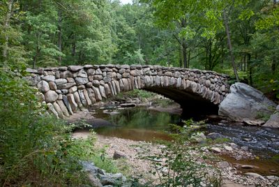
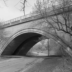
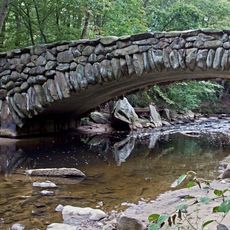
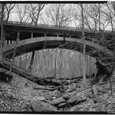
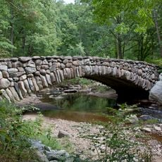
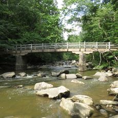
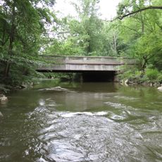
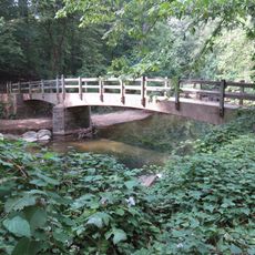
Boulder Bridge, Historic arch bridge in Rock Creek Park, Washington, D.C.

Boulder Bridge is an arch structure spanning Rock Creek with reinforced concrete faced with large fieldstones gathered from outside the park. The bridge connects both sides of the stream and measures approximately 60 feet (18 meters) in length with a distinctive appearance created by its stone cladding.

Built in 1902, the bridge was one of the earliest infrastructure projects in Rock Creek Park, constructed long before the National Park Service took over the area. It represented an early effort to develop the park's pathways and crossing points for visitors.

The bridge shows how early twentieth-century builders tried to blend human-made structures with natural surroundings in public parks. Its design demonstrates the thinking of that era about how infrastructure could work within a landscape rather than dominate it.

The bridge can be reached from multiple park entry points, with the Nature Center parking area and nearby picnic areas providing the easiest approach. The crossing itself is straightforward, though the surrounding paths can vary in width and condition depending on the season and recent maintenance.

The fieldstones used for the bridge's cladding were sourced from outside the park, a building choice that reflects how materials were transported from various locations during that era. Just upstream sits the former location of a nineteenth-century mill that once processed grain for the surrounding communities.

The community of curious travelers

AroundUs brings together thousands of curated places, local tips, and hidden gems, enriched daily by 60,000 contributors worldwide.

Start exploring
Location
GPS coordinates
38.94834,-77.04495
Latest update
December 14, 2025 13:04
Around this place
Hillwood Estate, Museum & Gardens
United States of America

Hillwood Estate, Museum & Gardens

840 m
Northwest
United States of America

Northwest

1.5 km
Adas Israel Congregation
United States of America

Adas Israel Congregation

1.7 km
Twelve Monograms
United States of America

Twelve Monograms

840 m
Carter Barron Amphitheatre
United States of America

Carter Barron Amphitheatre

353 m
Pierce-Klingle Mansion
United States of America

Pierce-Klingle Mansion

1.2 km
Intelsat headquarters
United States of America

Intelsat headquarters

1.7 km
Peirce Mill
United States of America

Peirce Mill

1.1 km
16th Street Bridge
United States of America

16th Street Bridge

1.4 km
Sedgwick Gardens
United States of America

Sedgwick Gardens

1.7 km
Cathedral of St. John the Baptist
United States of America

Cathedral of St. John the Baptist

1.1 km
Iglesia ni Cristo chapel, Washington D.C.
United States of America

Iglesia ni Cristo chapel, Washington D.C.

1.1 km
Washington Heights Historic District
United States of America

Washington Heights Historic District

524 m
Rosedale
United States of America

Rosedale

1.1 km
Pierce Springhouse and Barn
United States of America

Pierce Springhouse and Barn

1.1 km
Boulder Bridge and Ross Drive Bridge
United States of America

Boulder Bridge and Ross Drive Bridge

1 m
Ross Drive Bridge
United States of America

Ross Drive Bridge

582 m
Cloverdale
United States of America

Cloverdale

1.2 km
Building at 3901 Connecticut Ave., NW
United States of America

Building at 3901 Connecticut Ave., NW

1.6 km
Ingleside
United States of America

Ingleside

1.6 km
Peirce Still House
United States of America

Peirce Still House

1.1 km
Rock Creek Park Nature Center and Planetarium
United States of America

Rock Creek Park Nature Center and Planetarium

1.4 km
Morris House
United States of America

Morris House

1.1 km
Rock Creek Park Historic District
United States of America

Rock Creek Park Historic District

0 m
Soapstone Valley Park
United States of America

Soapstone Valley Park

1.3 km
Rapids Footbridge
United States of America

Rapids Footbridge

569 m
Joyce Road Bridge
United States of America

Joyce Road Bridge

1.4 km
Bluff Bridge
United States of America

Bluff Bridge

1.3 km
Show the full map
Reviews
Share your experience

No review yet

Discussions
Start a discussion...

No discussion yet

« Boulder Bridge - Historic arch bridge in Rock Creek Park, Washington, D.C » is provided by Around Us (aroundus.com). Images and texts are derived from Wikimedia project under a Creative Commons license. You are allowed to copy, distribute, and modify copies of this page, under the conditions set by the license, as long as this note is clearly visible.

Discover hidden gems everywhere you go!

From secret cafés to breathtaking viewpoints, skip the crowded tourist spots and find places that match your style. Our app makes it easy with voice search, smart filtering, route optimization, and insider tips from travelers worldwide. Download now for the complete mobile experience.

Around Us App Screenshot

A unique approach to discovering new places

Le Figaro

All the places worth exploring

France Info

A tailor-made excursion in just a few clicks

20 Minutes

Around Us
Travel Guide & Maps
Download

Send to your phone

QR Code
1

Open the camera app on your mobile.

2

Point at the QR code with your camera. A notification will appear.

3

Tap the notification to open the link.