Enable Location

We need your location to show you interesting places around you

Discover nearby places

Find interesting locations and hidden gems around you

Precise directions

Get accurate directions and distances to places

Your location is never shared with other users. It's only used when you tap the location button.

McConnells Mill State Park

Log in to your account

Start exploring — it's free

Trusted by 61,856 travelers worldwide

Continue with Google
Continue with Apple
or

We will send you a code to connect

By continuing, you accept our Terms and Conditions and our Privacy Policy

Check your inbox

We've sent a pincode in your inbox. Please enter the code below.

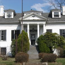
McConnells Mill State Park, State park and National Natural Landmark in Lawrence County, Pennsylvania.

Description

McConnells Mill State Park is a nature reserve and National Natural Landmark in Lawrence County, Pennsylvania, spanning 2,546 acres. Slippery Rock Creek flows through a deep gorge surrounded by limestone cliffs, steep walls, and numerous rock formations that define the terrain.

History

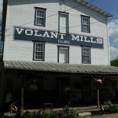
A watermill built in 1852 operated in the area until 1928, processing grain for local farmers as western Pennsylvania grew industrially during that period. This facility reflects the region's reliance on water-powered manufacturing.

Culture

Families have long come here for trout fishing, hiking, and nature photography along the established trails through the landscape. These traditional outdoor activities shape how people move through and connect with the land today.

Practical

Several parking areas near trailheads provide maps and information boards directing visitors to hiking paths, climbing zones, and fishing spots throughout the park. Wear sturdy footwear and come prepared for changing conditions along the water and on steep trails.

Did you know?

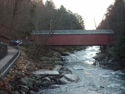
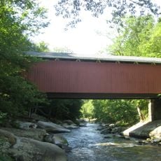
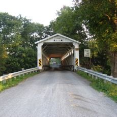
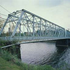
A covered bridge from 1874 spans Slippery Rock Creek for about 101 feet with its original timber framework still visible. Modern reinforcements allow vehicles to cross while preserving the historic structure.

Location
Inception
1957
Operator
Pennsylvania Bureau of State Parks
GPS coordinates
40.92670,-80.19000
Latest update
December 7, 2025 20:40

AroundUs brings together thousands of curated places, local tips, and hidden gems, enriched daily by 60,000 contributors worldwide. Discover all places nearby (Lawrence County).

Around this place
Moraine State Park
United States of America

Moraine State Park

6 km
Pittsburgh International Race Complex
United States of America

Pittsburgh International Race Complex

15.5 km
Cascade Park
United States of America

Cascade Park

12.4 km
Jennings Environmental Education Center
United States of America

Jennings Environmental Education Center

18.3 km
Harmony Historic District
United States of America

Harmony Historic District

14.7 km
Scottish Rite Cathedral
United States of America

Scottish Rite Cathedral

15.7 km
Fun Fore All
United States of America

Fun Fore All

25.3 km
Strand Theater
United States of America

Strand Theater

15.2 km
Carnegie Free Library of Beaver Falls
United States of America

Carnegie Free Library of Beaver Falls

22.2 km
Merrick Art Gallery
United States of America

Merrick Art Gallery

23.9 km
McConnell's Mill Covered Bridge
United States of America

McConnell's Mill Covered Bridge

3.3 km
William B. Dunlap Mansion
United States of America

William B. Dunlap Mansion

26 km
Banks Covered Bridge
United States of America

Banks Covered Bridge

19.9 km
Eastvale Bridge
United States of America

Eastvale Bridge

20.8 km
Bridgewater Historic District
United States of America

Bridgewater Historic District

26.1 km
Fallston Bridge
United States of America

Fallston Bridge

24.4 km
McClelland Homestead
United States of America

McClelland Homestead

23.2 km
S.R. Thompson House
United States of America

S.R. Thompson House

24.5 km
Passavant House
United States of America

Passavant House

15.5 km
Rochester-Beaver Railroad Bridge
United States of America

Rochester-Beaver Railroad Bridge

26.8 km
Old Homestead
United States of America

Old Homestead

24.4 km
Volant Mills
United States of America

Volant Mills

21.5 km
Beaver River Railroad Bridge
United States of America

Beaver River Railroad Bridge

23.5 km
Lakeview Beach
United States of America

Lakeview Beach

7.6 km
Pleasant Valley Beach
United States of America

Pleasant Valley Beach

8.8 km
James Beach Clow House
United States of America

James Beach Clow House

12.6 km
New Castle Armory
United States of America

New Castle Armory

12.8 km
Lawrence County Courthouse
United States of America

Lawrence County Courthouse

14.9 km
Show the full map
« McConnells Mill State Park - State park and National Natural Landmark in Lawrence County, Pennsylvania » is provided by Around Us (aroundus.com). Images and texts are derived from Wikimedia project under a Creative Commons license. You are allowed to copy, distribute, and modify copies of this page, under the conditions set by the license, as long as this note is clearly visible.

Discover hidden gems everywhere you go!

From secret cafés to breathtaking viewpoints, skip the crowded tourist spots and find places that match your style. Our app makes it easy with voice search, smart filtering, route optimization, and insider tips from travelers worldwide. Download now for the complete mobile experience.

Around Us App Screenshot

A unique approach to discovering new places

Le Figaro

All the places worth exploring

France Info

A tailor-made excursion in just a few clicks

20 Minutes

Around Us
Travel Guide & Maps
Download

Send to your phone

QR Code
1

Open the camera app on your mobile.

2

Point at the QR code with your camera. A notification will appear.

3

Tap the notification to open the link.