McConnell's Mill Covered Bridge

Log in to your account

AroundUs is a community-driven map of interesting places, built by curious explorers like you. It grows with every review, story, and photo you share.
Connect to save your favorite spots, contribute locations, and create personalized routes.
Continue with Google
Continue with Apple
Continue with X
Continue with Facebook
Continue with email
By continuing, you accept our Terms and Conditions and our Privacy Policy
Create an account
Add to collection
Map
Suggest a change
Share

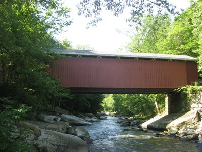
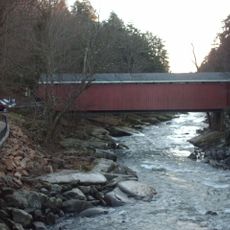
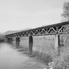
McConnell's Mill Covered Bridge, Wooden covered bridge in Slippery Rock Township, United States.

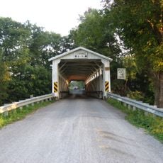
McConnell's Mill Covered Bridge is a wooden crossing over Slippery Rock Creek in northwestern Pennsylvania with red exterior walls and sturdy stone piers. The structure connects both banks and provides access to hiking trails and the historic mill complex in the adjoining state park.

The structure was built during the second half of the 19th century and belongs to a small group of covered bridges ever constructed in this county. Only a handful of these structures survive today, making it a rare example of this construction method from that era.

The bridge once served as a vital transportation link for moving goods from the local mill to surrounding communities. It reflects the role such structures played in connecting rural settlements during Pennsylvania's industrial development.

The crossing is located within a state park and allows visitors easy access to hiking trails and the mill area. The location is easily reached and offers ample parking space along with room to explore the surrounding landscape.

The structure uses a special truss system with wooden compression members and iron rods, a construction method found in only a few surviving bridges in this state. This technical feature made the bridge more durable and allowed it to carry heavy loads for decades.

Location: Slippery Rock Township

Inception: 1874

GPS coordinates: 40.95278,-80.17028

Latest update: December 14, 2025 14:22

Photos
Around this place
Moraine State Park
United States of America

Moraine State Park

3.6 km
McConnells Mill State Park
United States of America

McConnells Mill State Park

3.3 km
Wendell August Forge
United States of America

Wendell August Forge

25.3 km
Elm Court
United States of America

Elm Court

25.2 km
Cascade Park
United States of America

Cascade Park

13 km
Jennings Environmental Education Center
United States of America

Jennings Environmental Education Center

15.4 km
Butler County Courthouse
United States of America

Butler County Courthouse

25.4 km
Harmony Historic District
United States of America

Harmony Historic District

17 km
Scottish Rite Cathedral
United States of America

Scottish Rite Cathedral

15.8 km
Strand Theater
United States of America

Strand Theater

17.6 km
Carnegie Free Library of Beaver Falls
United States of America

Carnegie Free Library of Beaver Falls

25.6 km
Merrick Art Gallery
United States of America

Merrick Art Gallery

27.2 km
Banks Covered Bridge
United States of America

Banks Covered Bridge

18.2 km
Eastvale Bridge
United States of America

Eastvale Bridge

24.2 km
Fallston Bridge
United States of America

Fallston Bridge

27.7 km
McClelland Homestead
United States of America

McClelland Homestead

24 km
Sen. Walter Lowrie House
United States of America

Sen. Walter Lowrie House

25.3 km
S.R. Thompson House
United States of America

S.R. Thompson House

23 km
Passavant House
United States of America

Passavant House

18 km
Butler Historic District
United States of America

Butler Historic District

25.4 km
Old Homestead
United States of America

Old Homestead

26.8 km
Volant Mills
United States of America

Volant Mills

19.3 km
Butler County National Bank
United States of America

Butler County National Bank

25.4 km
Beaver River Railroad Bridge
United States of America

Beaver River Railroad Bridge

26.8 km
Guthrie Theatre
United States of America

Guthrie Theatre

24 km
James Beach Clow House
United States of America

James Beach Clow House

16 km
New Castle Armory
United States of America

New Castle Armory

13.3 km
Lawrence County Courthouse
United States of America

Lawrence County Courthouse

15.1 km
Show the full map
Reviews

Visited this place? Tap the stars to rate it and share your experience / photos with the community! Try now! You can cancel it anytime.

« McConnell's Mill Covered Bridge - Wooden covered bridge in Slippery Rock Township, United States » is provided by Around Us (aroundus.com). Images and texts are derived from Wikimedia project under a Creative Commons license. You are allowed to copy, distribute, and modify copies of this page, under the conditions set by the license, as long as this note is clearly visible.

Discover hidden gems everywhere you go!

From secret cafés to breathtaking viewpoints, skip the crowded tourist spots and find places that match your style. Our app makes it easy with voice search, smart filtering, route optimization, and insider tips from travelers worldwide. Download now for the complete mobile experience.

Around Us App Screenshot

A unique approach to discovering new places

Le Figaro

All the places worth exploring

France Info

A tailor-made excursion in just a few clicks

20 Minutes