Enable Location

We need your location to show you interesting places around you

Discover nearby places

Find interesting locations and hidden gems around you

Precise directions

Get accurate directions and distances to places

Your location is never shared with other users. It's only used when you tap the location button.

Pennsalt Historic District

Log in to your account

Start exploring — it's free

Trusted by 61,974 travelers worldwide

Continue with Google
Continue with Apple
or

We will send you a code to connect

By continuing, you accept our Terms and Conditions and our Privacy Policy

Check your inbox

We've sent a pincode in your inbox. Please enter the code below.

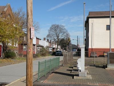
Pennsalt Historic District, Historical residential district in Harrison Township, US.

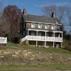
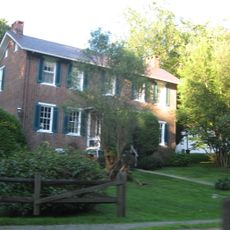
Pennsalt Historic District is a residential area in Harrison Township containing over 150 buildings from the 19th century. The houses form six blocks of buildings parallel to the Allegheny River, with simple one-story wooden cottages and two-story brick rowhouses mixed throughout.

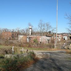
The Pennsylvania Salt Manufacturing Company founded this community in the 1850s as a place for its workers to live. The company gradually expanded the settlement over several decades into a complete company town.

The buildings show how factory workers lived in the 19th century, with simple yet sturdy structures made of stone and wood. You can see how tightly the homes were arranged and how the community was designed around workers' needs.

The district is easy to explore on foot since the buildings are arranged in compact blocks. The best time to visit is during daytime when light brings out the architectural details of the homes.

The district preserves its original layout from the 1850s nearly unchanged, with street patterns and building arrangements that still reflect factory worker culture today. This makes it a rare example of a fully intact industrial worker settlement.

The community of curious travelers

AroundUs brings together thousands of curated places, local tips, and hidden gems, enriched daily by 60,000 contributors worldwide.

Start exploring
GPS coordinates
40.61469,-79.72131
Latest update
December 14, 2025 18:41
Around this place
Oakmont Country Club
United States of America

Oakmont Country Club

13.3 km
Allegheny Islands State Park
United States of America

Allegheny Islands State Park

12.6 km
Rachel Carson Trail
United States of America

Rachel Carson Trail

5.6 km
Rachel Carson Homestead
United States of America

Rachel Carson Homestead

9.2 km
Jonathon Hulton Bridge
United States of America

Jonathon Hulton Bridge

14.4 km
Burtner House
United States of America

Burtner House

2 km
Allegheny River Turnpike Bridge
United States of America

Allegheny River Turnpike Bridge

12.1 km
Bessemer & Lake Erie Railroad Bridge
United States of America

Bessemer & Lake Erie Railroad Bridge

12 km
Allegheny River Lock and Dam No. 3
United States of America

Allegheny River Lock and Dam No. 3

11.6 km
Allegheny River Lock and Dam No. 4
United States of America

Allegheny River Lock and Dam No. 4

416 m
Harrison Hills Park
United States of America

Harrison Hills Park

4.3 km
Drake Log Cabin
United States of America

Drake Log Cabin

13.7 km
St. Gertrude Roman Catholic Church
United States of America

St. Gertrude Roman Catholic Church

13 km
Allegheny River Lock and Dam No. 5
United States of America

Allegheny River Lock and Dam No. 5

9.2 km
George D. Stuart Bridge
United States of America

George D. Stuart Bridge

3.5 km
New Kensington Downtown Historic District
United States of America

New Kensington Downtown Historic District

6.6 km
Donald R. Lobaugh Bridge
United States of America

Donald R. Lobaugh Bridge

6.5 km
Valley Sports Complex
United States of America

Valley Sports Complex

4.4 km
New Kensington Production Works Historic District
United States of America

New Kensington Production Works Historic District

6.9 km
Freeport Rail Bridge
United States of America

Freeport Rail Bridge

8.2 km
Dr. Thomas R. Kerr House and Office
United States of America

Dr. Thomas R. Kerr House and Office

14.8 km
Vandergrift Historic District
United States of America

Vandergrift Historic District

13.5 km
John Walter Farmstead
United States of America

John Walter Farmstead

13.4 km
Byerly House
United States of America

Byerly House

7.5 km
Leechburg Bridge
United States of America

Leechburg Bridge

9.6 km
Logans Ferry Powder Works Historic District
United States of America

Logans Ferry Powder Works Historic District

9.3 km
Mill Bridge
United States of America

Mill Bridge

9 km
University of Pittsburgh Applied Research Center
United States of America

University of Pittsburgh Applied Research Center

12 km
Show the full map
« Pennsalt Historic District - Historical residential district in Harrison Township, US » is provided by Around Us (aroundus.com). Images and texts are derived from Wikimedia project under a Creative Commons license. You are allowed to copy, distribute, and modify copies of this page, under the conditions set by the license, as long as this note is clearly visible.

Discover hidden gems everywhere you go!

From secret cafés to breathtaking viewpoints, skip the crowded tourist spots and find places that match your style. Our app makes it easy with voice search, smart filtering, route optimization, and insider tips from travelers worldwide. Download now for the complete mobile experience.

Around Us App Screenshot

A unique approach to discovering new places

Le Figaro

All the places worth exploring

France Info

A tailor-made excursion in just a few clicks

20 Minutes

Around Us
Travel Guide & Maps
Download

Send to your phone

QR Code
1

Open the camera app on your mobile.

2

Point at the QR code with your camera. A notification will appear.

3

Tap the notification to open the link.