Enable Location

We need your location to show you interesting places around you

Discover nearby places

Find interesting locations and hidden gems around you

Precise directions

Get accurate directions and distances to places

Your location is never shared with other users. It's only used when you tap the location button.

Lock 23

Log in to your account

Start exploring — it's free

Trusted by 63,115 travelers worldwide

Continue with Google
Continue with Apple
or

We will send you a code to connect

By continuing, you accept our Terms and Conditions and our Privacy Policy

Check your inbox

We've sent a pincode in your inbox. Please enter the code below.

Lock 23
Discussion Reviews 1 Photos
1.9k Popularity

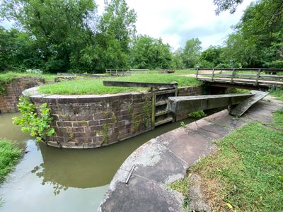
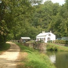
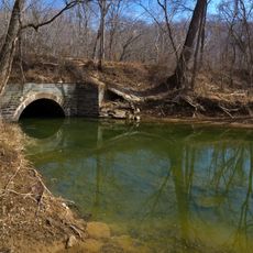
Lock 23, Canal lock in Darnestown, United States.

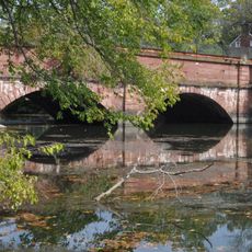
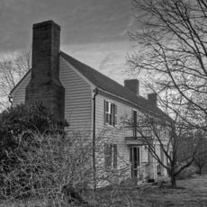
Lock 23 is a canal lock made of red sandstone from Seneca Quarry, located on the Chesapeake & Ohio Canal in Darnestown. The structure sits at an elevation of 54 meters above sea level and remains a visible part of the historic water system.

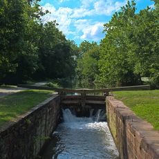
The lock was built as a critical point in the canal's water management system, supported by Dam No. 2 during operations. Between 1938 and 1942, the Civilian Conservation Corps performed restoration work to maintain water levels from this location downstream to Georgetown.

The lock got its alternate name, Violettes Lock, from Alfred Violet, the last locktender who worked here. You can still sense the connection between the structure and the people who operated it daily.

The site provides parking areas, canoe and kayak launching ramps, and restroom facilities for visitors. Wear comfortable walking shoes to explore the surrounding paths and view the structure from different angles.

The red sandstone used in the lock came from the nearby Seneca Quarry, making it a notable example of using local materials for construction. This choice of sourcing stone from the area helped the structure maintain its integrity over the years.

The community of curious travelers

AroundUs brings together thousands of curated places, local tips, and hidden gems, enriched daily by 60,000 contributors worldwide.

Start exploring
Elevation above the sea
54 m
Made from material
sandstone
GPS coordinates
39.06694,-77.32889
Latest update
December 14, 2025 11:02
Around this place
Glenstone
United States of America

Glenstone

6.6 km
Trump National Golf Club
United States of America

Trump National Golf Club

2.2 km
Seneca Quarry
United States of America

Seneca Quarry

2.5 km
McKee-Beshers Wildlife Management Area
United States of America

McKee-Beshers Wildlife Management Area

6.1 km
Seneca Aqueduct
United States of America

Seneca Aqueduct

1.1 km
Swains Lock
United States of America

Swains Lock

8.4 km
Lock 22
United States of America

Lock 22

3.8 km
Travilah Oak
United States of America

Travilah Oak

5.7 km
Dranesville Tavern
United States of America

Dranesville Tavern

7.1 km
Broad Run Bridge and Tollhouse
United States of America

Broad Run Bridge and Tollhouse

9.3 km
Glenstone Museum
United States of America

Glenstone Museum

6.8 km
William Gunnell House
United States of America

William Gunnell House

8 km
Dierssen Wildlife Management Area
United States of America

Dierssen Wildlife Management Area

2.4 km
Vestal's Gap Road and Lanesville Historic District
United States of America

Vestal's Gap Road and Lanesville Historic District

8.5 km
Seneca Historic District
United States of America

Seneca Historic District

3.1 km
Darnestown Presbyterian Church
United States of America

Darnestown Presbyterian Church

5.5 km
Bloomfield
United States of America

Bloomfield

6.8 km
Great Falls Grange Hall and Forestville School
United States of America

Great Falls Grange Hall and Forestville School

8.4 km
Edward Beale House
United States of America

Edward Beale House

9.2 km
Darnall Place
United States of America

Darnall Place

7.4 km
Valhalla
United States of America

Valhalla

9.3 km
John Gunnell House
United States of America

John Gunnell House

6.7 km
Susanna Farm
United States of America

Susanna Farm

8.2 km
Loudoun Heritage Farm Museum
United States of America

Loudoun Heritage Farm Museum

8.6 km
Muddy Branch
United States of America

Muddy Branch

5.5 km
Serpentine Barrens Conservation Park
United States of America

Serpentine Barrens Conservation Park

8.6 km
Cascades Library
United States of America

Cascades Library

6.8 km
Great Falls Community Library
United States of America

Great Falls Community Library

8.6 km
Show the full map
Reviews
Share your experience

No review yet

Discussions
Start a discussion...

No discussion yet

« Lock 23 - Canal lock in Darnestown, United States » is provided by Around Us (aroundus.com). Images and texts are derived from Wikimedia project under a Creative Commons license. You are allowed to copy, distribute, and modify copies of this page, under the conditions set by the license, as long as this note is clearly visible.

Discover hidden gems everywhere you go!

From secret cafés to breathtaking viewpoints, skip the crowded tourist spots and find places that match your style. Our app makes it easy with voice search, smart filtering, route optimization, and insider tips from travelers worldwide. Download now for the complete mobile experience.

Around Us App Screenshot

A unique approach to discovering new places

Le Figaro

All the places worth exploring

France Info

A tailor-made excursion in just a few clicks

20 Minutes

Around Us
Travel Guide & Maps
Download

Send to your phone

QR Code
1

Open the camera app on your mobile.

2

Point at the QR code with your camera. A notification will appear.

3

Tap the notification to open the link.