Enable Location

We need your location to show you interesting places around you

Discover nearby places

Find interesting locations and hidden gems around you

Precise directions

Get accurate directions and distances to places

Your location is never shared with other users. It's only used when you tap the location button.

Lake Champlain Bridge

Log in to your account

Join the adventure

Create your free account and start exploring (like 60k+ others)

We will send you a code to connect

or
Continue with Google
Continue with Apple
By continuing, you accept our Terms and Conditions and our Privacy Policy

Check your inbox

We've sent a pincode in your inbox. Please enter the code below.

Lake Champlain Bridge

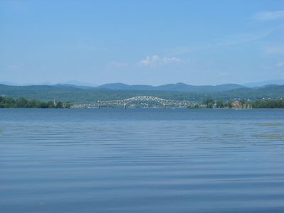
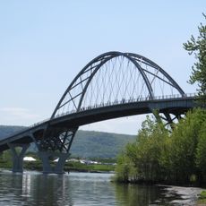
Lake Champlain Bridge, Steel truss bridge between Crown Point, New York and Chimney Point, Vermont.

Description

Lake Champlain Bridge is a steel truss structure spanning across the water with a distinctive central arch that rises prominently above the approach sections. The crossing accommodates multiple lanes for vehicles and provides dedicated space for pedestrians and cyclists on both sides.

History

The original structure opened in 1929 as a toll crossing and served as a crucial link between the two states for many decades. Safety issues led to its demolition in 2009, after which a replacement bridge was constructed to maintain the vital connection.

Culture

The bridge links two distinct communities across Lake Champlain, serving as a physical connection between Vermont and New York traditions. Visitors can feel how this crossing represents more than a simple passage, bridging cultural differences between neighboring regions.

Practical

The crossing accommodates all vehicle types and foot traffic throughout the day in both directions. Travelers should allow adequate time and be prepared for busy periods when heading between the states.

Did you know?

The central arch span was prefabricated at a separate location and then transported by barge to the site before being lifted into place. This construction approach solved the engineering challenge of installing a major span over the water without disrupting the lake.

Location
Location
Official opening
August 26, 1929
GPS coordinates
44.03250,-73.42330
Latest update
December 9, 2025 18:48

AroundUs brings together thousands of curated places, local tips, and hidden gems, enriched daily by 60,000 contributors worldwide. Discover all places nearby (Vermont).

Around this place
Fort Crown Point
United States of America

Fort Crown Point

727 m
Lake Champlain Bridge
United States of America

Lake Champlain Bridge

0 m
Snake Mountain
United States of America

Snake Mountain

11.9 km
Fort Saint-Frédéric
United States of America

Fort Saint-Frédéric

727 m
Crown Point Light
United States of America

Crown Point Light

325 m
Ironville Historic District
United States of America

Ironville Historic District

15.3 km
Grand Isle State Park
United States of America

Grand Isle State Park

17.7 km
Barber's Point Light
United States of America

Barber's Point Light

13.6 km
Essex County Fairgrounds
United States of America

Essex County Fairgrounds

17.3 km
John Strong Mansion Museum
United States of America

John Strong Mansion Museum

2.6 km
Addison Baptist Church
United States of America

Addison Baptist Church

11.5 km
Shoreham Congregational Church
United States of America

Shoreham Congregational Church

18.2 km
Wesleyan Methodist Church
United States of America

Wesleyan Methodist Church

17 km
Sherman Free Library
United States of America

Sherman Free Library

3.4 km
Moriah Town Office Building
United States of America

Moriah Town Office Building

3.6 km
Witherbee Memorial Hall
United States of America

Witherbee Memorial Hall

10.4 km
Camp Dudley Road Historic District
United States of America

Camp Dudley Road Historic District

13.6 km
Lake View Grange No. 970
United States of America

Lake View Grange No. 970

17.1 km
Paris and Anna Fletcher House
United States of America

Paris and Anna Fletcher House

10.3 km
District Six Schoolhouse
United States of America

District Six Schoolhouse

15.2 km
Central Powerhouse
United States of America

Central Powerhouse

11.1 km
Cotton Free Library
United States of America

Cotton Free Library

17 km
House at 215 School Street
United States of America

House at 215 School Street

17.8 km
District School No. 1
United States of America

District School No. 1

11.5 km
Witherell Farm
United States of America

Witherell Farm

17.7 km
John Hamilton Farmstead
United States of America

John Hamilton Farmstead

12.8 km
Mount Moriah Presbyterian Church
United States of America

Mount Moriah Presbyterian Church

3.5 km
Lemon Fair Sculpture Park
United States of America

Lemon Fair Sculpture Park

16.7 km
Show the full map
« Lake Champlain Bridge - Steel truss bridge between Crown Point, New York and Chimney Point, Vermont » is provided by Around Us (aroundus.com). Images and texts are derived from Wikimedia project under a Creative Commons license. You are allowed to copy, distribute, and modify copies of this page, under the conditions set by the license, as long as this note is clearly visible.

Discover hidden gems everywhere you go!

From secret cafés to breathtaking viewpoints, skip the crowded tourist spots and find places that match your style. Our app makes it easy with voice search, smart filtering, route optimization, and insider tips from travelers worldwide. Download now for the complete mobile experience.

Around Us App Screenshot

A unique approach to discovering new places

Le Figaro

All the places worth exploring

France Info

A tailor-made excursion in just a few clicks

20 Minutes

Around Us
Travel Guide & Maps
Download

Send to your phone

QR Code
1

Open the camera app on your mobile.

2

Point at the QR code with your camera. A notification will appear.

3

Tap the notification to open the link.