Enable Location

We need your location to show you interesting places around you

Discover nearby places

Find interesting locations and hidden gems around you

Precise directions

Get accurate directions and distances to places

Your location is never shared with other users. It's only used when you tap the location button.

King Covered Bridge

Log in to your account

Start exploring — it's free

Trusted by 62,841 travelers worldwide

Continue with Google
Continue with Apple
or

We will send you a code to connect

By continuing, you accept our Terms and Conditions and our Privacy Policy

Check your inbox

We've sent a pincode in your inbox. Please enter the code below.

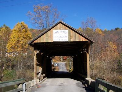
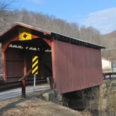
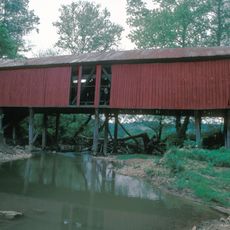
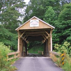
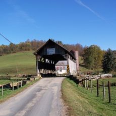
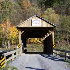
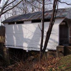
King Covered Bridge, Covered bridge in Wayne Township, Pennsylvania, US.

King Covered Bridge is a wooden bridge with a Queenpost truss design that crosses Hoover Run in Wayne Township. The structure features traditional timber construction and a covered gable roof that has been maintained in its original form.

This bridge was built in the nineteenth century as a vital transportation connection for local communities. It remains one of nine surviving covered bridges in Greene County.

The bridge reflects the period when covered bridges were essential elements of rural American infrastructure, protecting travelers and their horses from adverse weather conditions.

The bridge is located south of Kuhntown and can be reached via local roads. Visitors can view and photograph the original structural elements from nearby access points.

The bridge spans 0.1 acres and maintains its status on the National Register of Historic Places since June 1979, preserving its engineering and architectural characteristics.

The community of curious travelers

AroundUs brings together thousands of curated places, local tips, and hidden gems, enriched daily by 60,000 contributors worldwide.

Start exploring
Location
GPS coordinates
39.75704,-80.27259
Latest update
December 14, 2025 18:09
Around this place
Ryerson Station State Park
United States of America

Ryerson Station State Park

20.2 km
Mason and Dixon Survey Terminal Point
United States of America

Mason and Dixon Survey Terminal Point

13.8 km
Dents Run Covered Bridge
United States of America

Dents Run Covered Bridge

24.8 km
John Corbley Farm
United States of America

John Corbley Farm

22.4 km
Richard T. Foley Site
United States of America

Richard T. Foley Site

12.4 km
Miller Hall
United States of America

Miller Hall

17.4 km
Hanna Hall
United States of America

Hanna Hall

17.5 km
Fish Creek Covered Bridge
United States of America

Fish Creek Covered Bridge

18.1 km
White Covered Bridge
United States of America

White Covered Bridge

19.6 km
Charles Grant Heasley House
United States of America

Charles Grant Heasley House

17.7 km
Cameron Downtown
United States of America

Cameron Downtown

26.2 km
Neils Red Covered Bridge
United States of America

Neils Red Covered Bridge

23 km
Hamilton-Ely Farmstead
United States of America

Hamilton-Ely Farmstead

12.1 km
Wilson School
United States of America

Wilson School

26.3 km
Lippincott Covered Bridge
United States of America

Lippincott Covered Bridge

24.2 km
Bridge in Franklin Township
United States of America

Bridge in Franklin Township

17.2 km
Scott Covered Bridge
United States of America

Scott Covered Bridge

15.2 km
Greene Hills Farm
United States of America

Greene Hills Farm

19.4 km
William Cree House
United States of America

William Cree House

24.5 km
Grimes Covered Bridge
United States of America

Grimes Covered Bridge

24 km
George West Gordon Farm
United States of America

George West Gordon Farm

14.5 km
Shriver Covered Bridge
United States of America

Shriver Covered Bridge

10.6 km
Nettie Woods Covered Bridge
United States of America

Nettie Woods Covered Bridge

12.2 km
Waynesburg Historic District
United States of America

Waynesburg Historic District

17.2 km
Mannington Historic District
United States of America

Mannington Historic District

26.1 km
Thomas Kent, Jr., Farm
United States of America

Thomas Kent, Jr., Farm

15.8 km
Greene County Museum
United States of America

Greene County Museum

19.4 km
Cox Farm Covered Bridge
United States of America

Cox Farm Covered Bridge

24.2 km
Show the full map
« King Covered Bridge - Covered bridge in Wayne Township, Pennsylvania, US » is provided by Around Us (aroundus.com). Images and texts are derived from Wikimedia project under a Creative Commons license. You are allowed to copy, distribute, and modify copies of this page, under the conditions set by the license, as long as this note is clearly visible.

Discover hidden gems everywhere you go!

From secret cafés to breathtaking viewpoints, skip the crowded tourist spots and find places that match your style. Our app makes it easy with voice search, smart filtering, route optimization, and insider tips from travelers worldwide. Download now for the complete mobile experience.

Around Us App Screenshot

A unique approach to discovering new places

Le Figaro

All the places worth exploring

France Info

A tailor-made excursion in just a few clicks

20 Minutes

Around Us
Travel Guide & Maps
Download

Send to your phone

QR Code
1

Open the camera app on your mobile.

2

Point at the QR code with your camera. A notification will appear.

3

Tap the notification to open the link.