Mason and Dixon Survey Terminal Point, Boundary marker at intersection of Monongalia County and Greene County, United States.
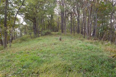
The Mason and Dixon Survey Terminal Point is a boundary marker located on Browns Hill at the Pennsylvania-West Virginia border. It marks the westernmost position reached during the survey of the Mason-Dixon line.
The marker was established in 1767 by surveyors Charles Mason and Jeremiah Dixon after they stopped their western progress at this location. The current stone was placed by Cephas H. Sinclair in 1883 directly on the original mound.
The terminal point represents the end of a boundary line that later defined geographical divisions between northern and southern states in America.
The site is located northeast of Pentress along County Route 39 in West Virginia and is straightforward to reach. The coordinates are 39.721111, -80.118611 for precise navigation to the marker.
The current stone marker, placed by Cephas H. Sinclair in 1883, stands in the exact mound left by Mason and Dixon in 1767.
The community of curious travelers
AroundUs brings together thousands of curated places, local tips, and hidden gems, enriched daily by 60,000 contributors worldwide.