Green Ridge State Forest

Log in to your account

AroundUs is a community-driven map of interesting places, built by curious explorers like you. It grows with every review, story, and photo you share.
Connect to save your favorite spots, contribute locations, and create personalized routes.
Continue with Google
Continue with Apple
Continue with X
Continue with Facebook
Continue with email
By continuing, you accept our Terms and Conditions and our Privacy Policy
Create an account
Add to collection
Map
Suggest a change
Share

Green Ridge State Forest, State forest and nature reserve in Allegany County, Maryland.

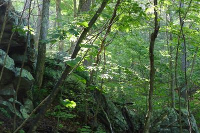
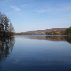
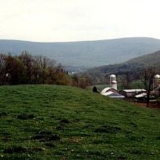
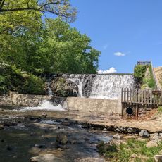
Green Ridge State Forest is a large protected woodland in Allegany County featuring varied landscapes, rivers, and abundant wildlife along the Potomac River. The land contains dense forest areas, open meadows, and waterways that together support a range of plants and animals throughout the seasons.

The Maryland Forest Service established this protected area in 1931, transforming former timber and mining lands into a nature conservation zone. This shift represented a broader effort to restore overworked landscapes and preserve them for the future.

The forest holds memories of former apple orchards that shaped the lives and livelihoods of people in the region for generations. This agricultural past remains visible in how the landscape is organized and in local stories about the land.

The area offers many hiking trails, camping spots, and fishing locations accessible from several entry points. Interstate 68 runs along the northern boundary and serves as a major landmark for visitors trying to find their way around.

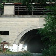
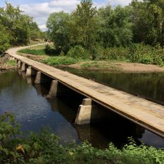
An abandoned railway path cuts through the land with several tunnels and old bridges from the era when trains crossed the region. These structures offer a glimpse into how people once moved goods and traveled through this area.

Location: Allegany County

Inception: 1931

Operator: Maryland Forest Service

Website: https://dnr.maryland.gov/forests/Pages/publiclands/western_greenridgeforest.aspx

GPS coordinates: 39.66528,-78.44306

Latest update: December 10, 2025 20:04

Photos
Around this place
Rocky Gap State Park
United States of America

Rocky Gap State Park

17.3 km
Samuel Taylor Suit Cottage
United States of America

Samuel Taylor Suit Cottage

18.7 km
Berkeley Springs State Park
United States of America

Berkeley Springs State Park

18.9 km
United States of America

Mid State Trail

16.8 km
Cacapon Resort State Park
United States of America

Cacapon Resort State Park

21.6 km
Buchanan State Forest
United States of America

Buchanan State Forest

20.6 km
Martin Hill
United States of America

Martin Hill

21.4 km
Roundtop Hill
United States of America

Roundtop Hill

17.9 km
United States of America

Pin Oak Fountain

25.2 km
Breakneck Road Historic District
United States of America

Breakneck Road Historic District

14.6 km
Michael Cresap House
United States of America

Michael Cresap House

20 km
Folck's Mill
United States of America

Folck's Mill

24 km
Morgan County Courthouse
United States of America

Morgan County Courthouse

18.9 km
Phoenix Mill Farm
United States of America

Phoenix Mill Farm

22.1 km
Town of Bath Historic District
United States of America

Town of Bath Historic District

18.9 km
Hewitt Covered Bridge
United States of America

Hewitt Covered Bridge

11.5 km
T. H. B. Dawson House
United States of America

T. H. B. Dawson House

19 km
Victor Cushwa Memorial Bridge
United States of America

Victor Cushwa Memorial Bridge

15.1 km
Clarence Hovermale House
United States of America

Clarence Hovermale House

18.9 km
Sloat-Horn-Rossell House
United States of America

Sloat-Horn-Rossell House

19.1 km
Cacapon State Park Nature Center
United States of America

Cacapon State Park Nature Center

22 km
Star Theatre
United States of America

Star Theatre

18.9 km
Judge John W. Wright Cottage
United States of America

Judge John W. Wright Cottage

19 km
John Herbert Quick House
United States of America

John Herbert Quick House

17.7 km
Gower House
United States of America

Gower House

26.5 km
Oldtown Bridge
United States of America

Oldtown Bridge

20.4 km
Hancock Bridge
United States of America

Hancock Bridge

22.2 km
Union Grove Schoolhouse
United States of America

Union Grove Schoolhouse

22.3 km
Show the full map
Reviews

Visited this place? Tap the stars to rate it and share your experience / photos with the community! Try now! You can cancel it anytime.

« Green Ridge State Forest - State forest and nature reserve in Allegany County, Maryland » is provided by Around Us (aroundus.com). Images and texts are derived from Wikimedia project under a Creative Commons license. You are allowed to copy, distribute, and modify copies of this page, under the conditions set by the license, as long as this note is clearly visible.

Discover hidden gems everywhere you go!

From secret cafés to breathtaking viewpoints, skip the crowded tourist spots and find places that match your style. Our app makes it easy with voice search, smart filtering, route optimization, and insider tips from travelers worldwide. Download now for the complete mobile experience.

Around Us App Screenshot

A unique approach to discovering new places

Le Figaro

All the places worth exploring

France Info

A tailor-made excursion in just a few clicks

20 Minutes