William Cullen Bryant Viaduct

Log in to your account

AroundUs is a community-driven map of interesting places, built by curious explorers like you. It grows with every review, story, and photo you share.
Connect to save your favorite spots, contribute locations, and create personalized routes.
Continue with Google
Continue with Apple
Continue with X
Continue with Facebook
Continue with email
By continuing, you accept our Terms and Conditions and our Privacy Policy
Create an account

William Cullen Bryant Viaduct

Add to collection
Map
Suggest a change
Share

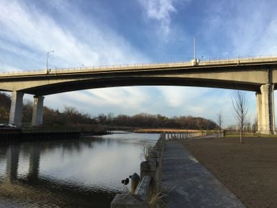
William Cullen Bryant Viaduct, Road bridge in Nassau County, United States

The William Cullen Bryant Viaduct is a road bridge in Nassau County that crosses Hempstead Harbor and connects the villages of Flower Hill and Roslyn on Long Island. The structure completed in 2012 features four traffic lanes, wider shoulders, and improved walkways to serve daily traffic needs.

The original viaduct opened in 1949 under Governor Thomas E. Dewey to ease traffic on Roslyn's Main Street and Old Northern Boulevard. Its replacement, completed in 2012, modernized regional infrastructure and reflected decades of changing transportation needs.

The bridge received its name in 2012 to honor William Cullen Bryant, a notable poet and journalist who made his home in Roslyn starting in 1843. This naming reflects how the area values its literary heritage and the writers who lived there.

The bridge carries roughly 38,000 vehicles daily and has enhanced drainage systems for weather management. Pedestrians and cyclists should use the designated pathways, particularly during peak traffic times when congestion is heaviest.

The replacement structure was the first in the region built using precast concrete segments, marking a construction advancement for local infrastructure. This building method allowed faster assembly and better quality control compared to traditional on-site construction techniques.

Location: New York

Location: Nassau County

Location: Flower Hill

Location: Roslyn

Inception: 1949

GPS coordinates: 40.80380,-73.65100

Latest update: December 14, 2025 12:26

Photos
Around this place
Harbor Hill
United States of America

Harbor Hill

1.1 km
Inisfada
United States of America

Inisfada

2.4 km
Nassau County Museum of Art
United States of America

Nassau County Museum of Art

947 m
Cedarmere-Clayton Estates
United States of America

Cedarmere-Clayton Estates

923 m
Mackay Estate Dairyman's Cottage
United States of America

Mackay Estate Dairyman's Cottage

2.2 km
Main Street Historic District
United States of America

Main Street Historic District

759 m
Mackay Estate Gate Lodge
United States of America

Mackay Estate Gate Lodge

1.4 km
Mackay Estate Water Tower
United States of America

Mackay Estate Water Tower

1.2 km
Roslyn Grist Mill
United States of America

Roslyn Grist Mill

413 m
Roslyn Village Historic District
United States of America

Roslyn Village Historic District

475 m
United States of America

Ellen E. Ward Memorial Clock Tower

453 m
Flower Hill Village Hall
United States of America

Flower Hill Village Hall

2.3 km
Willowmere
United States of America

Willowmere

1.3 km
Willet Titus House
United States of America

Willet Titus House

329 m
Toll Gate House
United States of America

Toll Gate House

1.7 km
Sands-Willets Homestead
United States of America

Sands-Willets Homestead

2.8 km
Greenridge-Arthur Williams House
United States of America

Greenridge-Arthur Williams House

2.3 km
Trinity Church Complex
United States of America

Trinity Church Complex

478 m
Stephen and Charles Smith House
United States of America

Stephen and Charles Smith House

1.1 km
Roslyn Savings Bank Building
United States of America

Roslyn Savings Bank Building

428 m
Clapham-Stern House
United States of America

Clapham-Stern House

1.9 km
George W. Denton House
United States of America

George W. Denton House

368 m
Roslyn National Bank and Trust Company Building
United States of America

Roslyn National Bank and Trust Company Building

409 m
Clifton
United States of America

Clifton

983 m
Samuel Adams Warner House
United States of America

Samuel Adams Warner House

1.4 km
Springbank
United States of America

Springbank

1.1 km
Mudge Farmhouse
United States of America

Mudge Farmhouse

2.3 km
Eastman Cottage
United States of America

Eastman Cottage

290 m
Show the full map
Reviews

Visited this place? Tap the stars to rate it and share your experience / photos with the community! Try now! You can cancel it anytime.

« William Cullen Bryant Viaduct - Road bridge in Nassau County, United States » is provided by Around Us (aroundus.com). Images and texts are derived from Wikimedia project under a Creative Commons license. You are allowed to copy, distribute, and modify copies of this page, under the conditions set by the license, as long as this note is clearly visible.

Discover hidden gems everywhere you go!

From secret cafés to breathtaking viewpoints, skip the crowded tourist spots and find places that match your style. Our app makes it easy with voice search, smart filtering, route optimization, and insider tips from travelers worldwide. Download now for the complete mobile experience.

Around Us App Screenshot

A unique approach to discovering new places

Le Figaro

All the places worth exploring

France Info

A tailor-made excursion in just a few clicks

20 Minutes