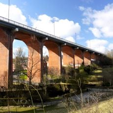
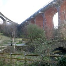
Byker Viaduct, Railway viaduct in Newcastle upon Tyne, United Kingdom.
The Byker Viaduct is a concrete railway bridge that spans the valley to connect Manors and Byker Metro stations in Newcastle. The structure follows an S-shaped curve as it carries the Tyne and Wear Metro line across the Ouseburn Valley.
This bridge was constructed between 1976 and 1979 as part of Newcastle's new metro line expansion to the east. It was notable for introducing innovative concrete joining techniques that had not been used before in British bridge construction.
The viaduct dominates the Byker skyline and is visible from many parts of the city, creating a distinctive visual landmark. Residents and visitors experience it as a defining feature of the local landscape that shapes how they perceive the area.
The bridge is easily recognized from ground level and is accessible via the metro stations at both ends. The best way to experience it is to ride the metro train across while observing its engineering from the train windows or platforms.
The structure is made of 253 individual concrete segments carefully assembled on site, with each piece weighing around 40 tonnes. The construction process required specialized engineering and precise alignment techniques to ensure all sections fit together correctly.
GPS coordinates: 54.97613,-1.59301
Latest update: December 12, 2025 14:24
Victoria Tunnel
467 m
Television Centre, Newcastle upon Tyne
541 m
Seven Stories
176 m
The Cluny
131 m
The Biscuit Factory
303 m
Church of St Dominic
375 m
Ouseburn Viaduct
30 m
Byker Bridge
67 m
Milecastle 3
257 m
Ouseburn Farm
132 m
Victoria Tunnel
457 m
Church of St Ann
425 m
Church of St Silas
469 m
Cooperative Wholesale Society Warehouse
764 m
Tom Collins House
598 m
Christ Church
614 m
Salvation Army Men's Palace
723 m
1-75 Dunn Terrace, including Graham House, Wolseley House, The Cabin, YMCA Byker Neighbourhood Youth Project, 1-66 Northumberland Terrace, Salisbury House
481 m
The war memorial cross of St Cuthbert's Church, Newcastle upon Tyne
449 m
Bridge Over Ouseburn
83 m
Cluny Warehouse
152 m
Gibson Street Baths
408 m
Piers, Walls And Railings South Of Former Ouseburn Schools
605 m
Sailors Bethel
514 m
Drinking Fountain And Statue
543 m
2-38 Kendal Street with retaining walls
729 m
1-17 Kendal House, 1-21 Gordon House, 1-47 Dalton Crescent, 1-58 Shipley Walk, and 1-18 Brinkburn Court with attached garden walls
667 m
Education Committee Distribution Centre Office (ouseburn Schools)
570 mVisited this place? Tap the stars to rate it and share your experience / photos with the community! Try now! You can cancel it anytime.
Discover hidden gems everywhere you go!
From secret cafés to breathtaking viewpoints, skip the crowded tourist spots and find places that match your style. Our app makes it easy with voice search, smart filtering, route optimization, and insider tips from travelers worldwide. Download now for the complete mobile experience.
A unique approach to discovering new places❞
— Le Figaro
All the places worth exploring❞
— France Info
A tailor-made excursion in just a few clicks❞
— 20 Minutes