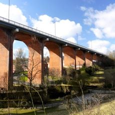
Ouseburn Viaduct, Railway viaduct in Newcastle upon Tyne, England
Ouseburn Viaduct is a large railway bridge crossing the Ouseburn Valley in Newcastle, built from sandstone and iron with several main arches supporting the structure high above the valley floor. It carries active rail traffic as part of the East Coast Main Line and features both substantial main spans and smaller approach sections.
The bridge was constructed during the early growth of British railways and reflects engineering approaches of that period. It underwent major changes during the second half of the 1800s to accommodate increased rail traffic.
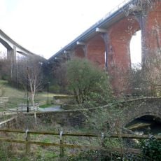
The structure shapes how people experience the Ouseburn Valley below, where the imposing arches frame views and create a landmark residents navigate by. Locals and visitors alike use the bridge as a reference point when exploring the surrounding industrial landscape.
The best views come from below in the valley where public footpaths allow you to walk near the base and see the full height and arch structure. You can reach these paths from local streets at the valley floor without needing to access railway property.
The viaduct originally used layered laminated wood in the spaces between its arches, an experimental technique that was uncommon in British bridge building when first installed. This unusual material choice shows how engineers tested different approaches before settling on iron as the standard.
Location: Newcastle upon Tyne
Inception: 1837
Official opening: 1839
GPS coordinates: 54.97640,-1.59305
Latest update: December 14, 2025 09:45
Victoria Tunnel
497 m
Television Centre, Newcastle upon Tyne
564 m
Seven Stories
205 m
The Cluny
157 m
The Biscuit Factory
296 m
Byker Viaduct
30 m
Church of St Dominic
391 m
Byker Bridge
94 m
Milecastle 3
264 m
Ouseburn Farm
153 m
Victoria Tunnel
486 m
Church of St Ann
454 m
Church of St Silas
475 m
Tom Collins House
612 m
Christ Church
616 m
Salvation Army Men's Palace
742 m
1-75 Dunn Terrace, including Graham House, Wolseley House, The Cabin, YMCA Byker Neighbourhood Youth Project, 1-66 Northumberland Terrace, Salisbury House
495 m
The war memorial cross of St Cuthbert's Church, Newcastle upon Tyne
477 m
Bridge Over Ouseburn
98 m
Piers, Walls And Railings South Of Former Ouseburn Schools
630 m
Cluny Warehouse
179 m
Gibson Street Baths
423 m
Sailors Bethel
543 m
Drinking Fountain And Statue
572 m
2-38 Kendal Street with retaining walls
741 m
1-17 Kendal House, 1-21 Gordon House, 1-47 Dalton Crescent, 1-58 Shipley Walk, and 1-18 Brinkburn Court with attached garden walls
676 m
Former Boiler House, Sandyford Brewery
768 m
Education Committee Distribution Centre Office (ouseburn Schools)
595 mVisited this place? Tap the stars to rate it and share your experience / photos with the community! Try now! You can cancel it anytime.
Discover hidden gems everywhere you go!
From secret cafés to breathtaking viewpoints, skip the crowded tourist spots and find places that match your style. Our app makes it easy with voice search, smart filtering, route optimization, and insider tips from travelers worldwide. Download now for the complete mobile experience.
A unique approach to discovering new places❞
— Le Figaro
All the places worth exploring❞
— France Info
A tailor-made excursion in just a few clicks❞
— 20 Minutes