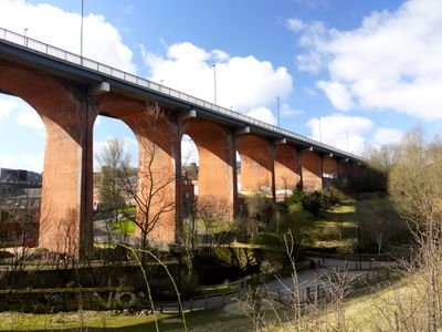
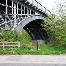
Byker Bridge, Road bridge in Byker, Newcastle upon Tyne, England
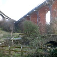
Byker Bridge is a brick and concrete road bridge that carries the A193 across the Ouseburn valley, linking Newcastle's center to its eastern districts. The structure features footpaths on both sides for pedestrians alongside vehicle traffic.
The bridge opened to pedestrians in 1878 and to vehicles in 1879, with a toll system that lasted until 1895. Its major transformation came in 1899 when cantilevered sections widened the deck.
The bridge shapes how people move through Byker today, with its brick form becoming part of the district's visual identity. Locals and visitors cross it regularly, making it an everyday landmark in the eastern neighborhoods.
The bridge can be crossed on foot or by car, though parking nearby is limited. Walking it at quieter times is advisable since the A193 experiences heavy traffic during peak hours.
The 1899 widening was done by adding cantilevered arms from the existing brickwork rather than rebuilding entirely. This clever engineering approach allowed the bridge to handle modern traffic without starting from scratch.
Location: Newcastle upon Tyne
GPS coordinates: 54.97563,-1.59243
Latest update: December 14, 2025 11:04
Victoria Tunnel
403 m
Television Centre, Newcastle upon Tyne
522 m
Seven Stories
111 m
The Cluny
65 m
The Biscuit Factory
353 m
Byker Viaduct
67 m
Church of St Dominic
381 m
Ouseburn Viaduct
94 m
Milecastle 3
221 m
Victoria Tunnel
392 m
Church of St Ann
381 m
Church of St Silas
430 m
Tom Collins House
544 m
Christ Church
646 m
Salvation Army Men's Palace
715 m
1-75 Dunn Terrace, including Graham House, Wolseley House, The Cabin, YMCA Byker Neighbourhood Youth Project, 1-66 Northumberland Terrace, Salisbury House
427 m
Bridge Over Ouseburn
54 m
The war memorial cross of St Cuthbert's Church, Newcastle upon Tyne
410 m
Gibson Street Baths
415 m
Sailors Bethel
452 m
Drinking Fountain And Statue
479 m
Cluny Warehouse
85 m
Piers, Walls And Railings South Of Former Ouseburn Schools
538 m
2-38 Kendal Street with retaining walls
679 m
1-17 Kendal House, 1-21 Gordon House, 1-47 Dalton Crescent, 1-58 Shipley Walk, and 1-18 Brinkburn Court with attached garden walls
621 m
Education Committee Distribution Centre Office (ouseburn Schools)
503 m
Caretaker's House To Former Ouseburn Schools
531 m
1, 2 And 3 And Attached Ramps
735 mVisited this place? Tap the stars to rate it and share your experience / photos with the community! Try now! You can cancel it anytime.
Discover hidden gems everywhere you go!
From secret cafés to breathtaking viewpoints, skip the crowded tourist spots and find places that match your style. Our app makes it easy with voice search, smart filtering, route optimization, and insider tips from travelers worldwide. Download now for the complete mobile experience.
A unique approach to discovering new places❞
— Le Figaro
All the places worth exploring❞
— France Info
A tailor-made excursion in just a few clicks❞
— 20 Minutes