Victoria Tunnel, Railway tunnel beneath Newcastle upon Tyne, England.
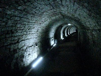
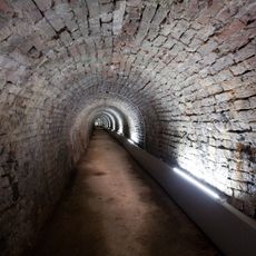
The Victoria Tunnel is a railway tunnel running under Newcastle upon Tyne, constructed with stone and brick in a sturdy arched design. The passage extends roughly 3.9 kilometers and sits at varying depths beneath the city streets.
Built between 1839 and 1842 by roughly 200 workers, the tunnel was designed to move coal from the Leazes Main Colliery to riverside loading docks. This project marked a turning point in how Newcastle transported its coal resources.
The tunnel got its name from an 1842 opening ceremony featuring coal wagons and a procession through the streets above. This reflected how important coal mining was to Newcastle's identity at that time.
Guided tours allow visitors to walk through around 700 meters of the tunnel, with tours starting from the Ouse Street entrance. Parking is available nearby at the Cycle Hub.
During World War II, the tunnel served as an air raid shelter for up to 9,000 people, complete with bunks, lighting, and reinforced concrete walls. This transformation shows how civilian spaces were repurposed during wartime bombing campaigns.
Location: Newcastle upon Tyne
GPS coordinates: 54.97214,-1.59071
Latest update: December 7, 2025 20:41
Gateshead Millennium Bridge
649 m
Baltic Centre for Contemporary Art
560 m
Television Centre, Newcastle upon Tyne
465 m
Seven Stories
292 m
HMS Calliope
602 m
The Cluny
347 m
Byker Viaduct
467 m
Church of St Dominic
514 m
Ouseburn Viaduct
497 m
Byker Bridge
403 m
Milecastle 3
432 m
Ouseburn Farm
371 m
Victoria Tunnel
17 m
Church of St Ann
239 m
Church of St Silas
517 m
Cooperative Wholesale Society Warehouse
635 m
Tom Collins House
461 m
1-75 Dunn Terrace, including Graham House, Wolseley House, The Cabin, YMCA Byker Neighbourhood Youth Project, 1-66 Northumberland Terrace, Salisbury House
397 m
The war memorial cross of St Cuthbert's Church, Newcastle upon Tyne
279 m
Bridge Over Ouseburn
426 m
Cluny Warehouse
324 m
Gibson Street Baths
542 m
Piers, Walls And Railings South Of Former Ouseburn Schools
232 m
Sailors Bethel
68 m
Drinking Fountain And Statue
76 m
2-38 Kendal Street with retaining walls
596 m
1-17 Kendal House, 1-21 Gordon House, 1-47 Dalton Crescent, 1-58 Shipley Walk, and 1-18 Brinkburn Court with attached garden walls
591 m
Education Committee Distribution Centre Office (ouseburn Schools)
218 mVisited this place? Tap the stars to rate it and share your experience / photos with the community! Try now! You can cancel it anytime.
Discover hidden gems everywhere you go!
From secret cafés to breathtaking viewpoints, skip the crowded tourist spots and find places that match your style. Our app makes it easy with voice search, smart filtering, route optimization, and insider tips from travelers worldwide. Download now for the complete mobile experience.
A unique approach to discovering new places❞
— Le Figaro
All the places worth exploring❞
— France Info
A tailor-made excursion in just a few clicks❞
— 20 Minutes