Swinging Bridge, Minnesota

Log in to your account

AroundUs is a community-driven map of interesting places, built by curious explorers like you. It grows with every review, story, and photo you share.
Connect to save your favorite spots, contribute locations, and create personalized routes.
By continuing, you accept our Terms and Conditions and our Privacy Policy
Add to collection
Map
Suggest a change
Share

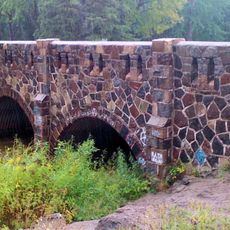
Swinging Bridge, Minnesota, Suspension footbridge at Twin Lakes, Minnesota.

The Swinging Bridge is a suspension bridge made of stone pillars and steel cables that spans the St. Louis River and accommodates pedestrians and cyclists. The structure features a footway suspended between sturdy supports that allow visitors to cross above the water.

Construction began in 1924 by the Forest Service as part of the park's infrastructure development. Major water events over the decades required significant repairs to keep the structure standing and safe for crossings.

The bridge draws locals who regularly walk or cycle across it as part of their daily routes through the park. It serves as a social gathering point where people from the surrounding area experience the river and forest together.

The bridge is open year-round for walkers and cyclists accessible from the nearby Jay Cooke State Park. Check weather conditions before visiting, as river conditions and surrounding terrain can affect safe crossing and trail use.

In the 1950s the bridge was substantially reinforced and raised to make it more resistant to river floods. These changes show how engineers adapted the structure to withstand nature's forces over time.

Location: Twin Lakes

GPS coordinates: 46.65364,-92.37041

Latest update: December 6, 2025 19:04

Minnesota secret locations and unusual places

Minnesota contains numerous locations away from the main tourist circuits. The state stretches from the shores of Lake Superior to the southern prairies, encompassing historic lighthouses, underground mines, waterfalls, and Japanese gardens. Visitors find both natural landscapes and cultural sites that tell the story of the region's history. Notable locations include prehistoric rock carvings at Jeffers Petroglyphs Site, where indigenous peoples left their marks thousands of years ago, and sacred trees of Ojibwe culture. The geological formation known as Devil's Kettle, a waterfall whose course puzzled scientists for years, attracts visitors interested in natural phenomena. Historic mines provide insight into Minnesota's industrial past, while lighthouses recall the maritime history along the largest of the Great Lakes.

Around this place
Show the full map
STR Edward L Ryerson
United States of America

STR Edward L Ryerson

22.4 km
Jay Cooke State Park
United States of America

Jay Cooke State Park

3.1 km
SS Meteor
United States of America

SS Meteor

24.7 km
Enger Tower
United States of America

Enger Tower

23.2 km
Richard I. Bong Memorial Bridge
United States of America

Richard I. Bong Memorial Bridge

19.3 km
R. W. Lindholm Service Station
United States of America

R. W. Lindholm Service Station

10.2 km
John A. Blatnik Bridge
United States of America

John A. Blatnik Bridge

23.1 km
Pattison State Park
United States of America

Pattison State Park

23.7 km
Big Manitou Falls
United States of America

Big Manitou Falls

23.1 km
Oliver Bridge
United States of America

Oliver Bridge

12.9 km
Cathedral of Christ the King
United States of America

Cathedral of Christ the King

22.4 km
Lincoln Branch Library
United States of America

Lincoln Branch Library

22.3 km
Church of Sts. Joseph and Mary-Catholic
United States of America

Church of Sts. Joseph and Mary-Catholic

20.6 km
Carlton County Courthouse
United States of America

Carlton County Courthouse

4.3 km
Douglas County Courthouse
United States of America

Douglas County Courthouse

22.2 km
Irving School
United States of America

Irving School

17.9 km
Bridge No. L6007
United States of America

Bridge No. L6007

12.2 km
Bridge No. 5757
United States of America

Bridge No. 5757

7.3 km
Cloquet City Hall
United States of America

Cloquet City Hall

10.6 km
Empire Block
United States of America

Empire Block

21.9 km
Berkshire Block
United States of America

Berkshire Block

21.9 km
Richard I. Bong Veterans Historical Center
United States of America

Richard I. Bong Veterans Historical Center

24.3 km
Cloquet-Northern Office Building
United States of America

Cloquet-Northern Office Building

10.5 km
Fairlawn Mansion
United States of America

Fairlawn Mansion

24.5 km
Jay Cooke State Park CCC/Rustic Style Historic District‎
United States of America

Jay Cooke State Park CCC/Rustic Style Historic District‎

99 m
Munger Terrace
United States of America

Munger Terrace

24.8 km
Jay Cooke State Park CCC/WPA/Rustic Style Picnic Grounds
United States of America

Jay Cooke State Park CCC/WPA/Rustic Style Picnic Grounds

1.4 km
Cloquet Lookout Tower
United States of America

Cloquet Lookout Tower

12.6 km
Show the full map

Reviews

Visited this place? Tap the stars to rate it and share your experience / photos with the community! Try now! You can cancel it anytime.

« Swinging Bridge, Minnesota - Suspension footbridge at Twin Lakes, Minnesota » is provided by Around Us (aroundus.com). Images and texts are derived from Wikimedia project under a Creative Commons license. You are allowed to copy, distribute, and modify copies of this page, under the conditions set by the license, as long as this note is clearly visible.

Discover hidden gems everywhere you go!

From secret cafés to breathtaking viewpoints, skip the crowded tourist spots and find places that match your style. Our app makes it easy with voice search, smart filtering, route optimization, and insider tips from travelers worldwide. Download now for the complete mobile experience.

Around Us App Screenshot

A unique approach to discovering new places

Le Figaro

All the places worth exploring

France Info

A tailor-made excursion in just a few clicks

20 Minutes