Enable Location

We need your location to show you interesting places around you

Discover nearby places

Find interesting locations and hidden gems around you

Precise directions

Get accurate directions and distances to places

Your location is never shared with other users. It's only used when you tap the location button.

Pattison State Park

Log in to your account

Start exploring — it's free

Trusted by 62,935 travelers worldwide

Continue with Google
Continue with Apple
or

We will send you a code to connect

By continuing, you accept our Terms and Conditions and our Privacy Policy

Check your inbox

We've sent a pincode in your inbox. Please enter the code below.

Pattison State Park
Discussion Reviews 1 Photos
6.8k Popularity

Pattison State Park, State park with waterfalls in Douglas County, Wisconsin, United States.
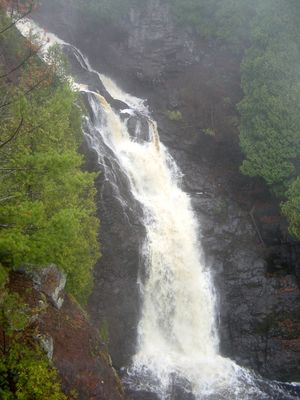
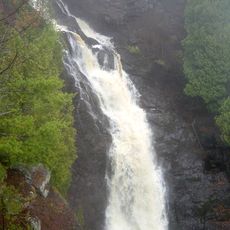
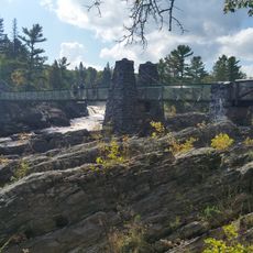
Pattison State Park is a protected natural area in Wisconsin featuring cascading waterfalls that plunge over rocky cliffs throughout the grounds. The park spans forested terrain with hiking trails of varying lengths, picnic areas, and camping facilities situated near the waterways.

A businessman named Martin Pattison donated his land to the state in 1920 to protect this natural landscape and its waterfalls from development. Since then the area has been managed as a state park, keeping the waterways and forests open for public use and enjoyment.

The falls hold significance for local communities and serve as a gathering place for people who come to experience the power of moving water. Visitors walking the grounds can sense how the landscape shapes how people spend their time outdoors and connect with nature here.

The park is easy to navigate on foot with marked trails and clear areas for resting, eating, and sleeping. Some paths are steep and slippery especially after rain, so wear sturdy shoes and take care when walking on wet ground.

The water plunges over dark volcanic rock formations that give the whole scene a striking look quite different from other waterfalls in the region. These unusual stone formations were created millions of years ago through volcanic activity in this area.

The community of curious travelers

AroundUs brings together thousands of curated places, local tips, and hidden gems, enriched daily by 60,000 contributors worldwide.

Start exploring
Location
Inception
1920
GPS coordinates
46.52670,-92.12220
Latest update
December 9, 2025 18:41
Around this place
STR Edward L Ryerson
United States of America

STR Edward L Ryerson

23.6 km
Jay Cooke State Park
United States of America

Jay Cooke State Park

21 km
SS Meteor
United States of America

SS Meteor

22.3 km
Enger Tower
United States of America

Enger Tower

27.8 km
Richard I. Bong Memorial Bridge
United States of America

Richard I. Bong Memorial Bridge

22.8 km
Amnicon Falls State Park
United States of America

Amnicon Falls State Park

19.6 km
John A. Blatnik Bridge
United States of America

John A. Blatnik Bridge

24.8 km
Big Manitou Falls
United States of America

Big Manitou Falls

1 km
Lake Superior Zoo
United States of America

Lake Superior Zoo

22.8 km
Minnesota Point Light
United States of America

Minnesota Point Light

21.7 km
Wisconsin Point Light
United States of America

Wisconsin Point Light

22.3 km
Oliver Bridge
United States of America

Oliver Bridge

15.7 km
Cathedral of Christ the King
United States of America

Cathedral of Christ the King

21.7 km
Davidson Windmill
United States of America

Davidson Windmill

21.5 km
Lincoln Branch Library
United States of America

Lincoln Branch Library

26.7 km
Carlton County Courthouse
United States of America

Carlton County Courthouse

27.8 km
Douglas County Courthouse
United States of America

Douglas County Courthouse

21.7 km
Irving School
United States of America

Irving School

23.5 km
Bridge No. L6007
United States of America

Bridge No. L6007

21.3 km
Bridge No. 5757
United States of America

Bridge No. 5757

19 km
Empire Block
United States of America

Empire Block

22 km
Berkshire Block
United States of America

Berkshire Block

22.3 km
Richard I. Bong Veterans Historical Center
United States of America

Richard I. Bong Veterans Historical Center

22.2 km
Fairlawn Mansion
United States of America

Fairlawn Mansion

21.8 km
Swinging Bridge, Minnesota
United States of America

Swinging Bridge, Minnesota

23.7 km
Davidson Windmill and Eskolin Log House
United States of America

Davidson Windmill and Eskolin Log House

21.5 km
Jay Cooke State Park CCC/Rustic Style Historic District‎
United States of America

Jay Cooke State Park CCC/Rustic Style Historic District‎

23.8 km
Jay Cooke State Park CCC/WPA/Rustic Style Picnic Grounds
United States of America

Jay Cooke State Park CCC/WPA/Rustic Style Picnic Grounds

22.7 km
Show the full map
Reviews
Share your experience

No review yet

Discussions
Start a discussion...

No discussion yet

« Pattison State Park - State park with waterfalls in Douglas County, Wisconsin, United States » is provided by Around Us (aroundus.com). Images and texts are derived from Wikimedia project under a Creative Commons license. You are allowed to copy, distribute, and modify copies of this page, under the conditions set by the license, as long as this note is clearly visible.

Discover hidden gems everywhere you go!

From secret cafés to breathtaking viewpoints, skip the crowded tourist spots and find places that match your style. Our app makes it easy with voice search, smart filtering, route optimization, and insider tips from travelers worldwide. Download now for the complete mobile experience.

Around Us App Screenshot

A unique approach to discovering new places

Le Figaro

All the places worth exploring

France Info

A tailor-made excursion in just a few clicks

20 Minutes

Around Us
Travel Guide & Maps
Download

Send to your phone

QR Code
1

Open the camera app on your mobile.

2

Point at the QR code with your camera. A notification will appear.

3

Tap the notification to open the link.