Enable Location

We need your location to show you interesting places around you

Discover nearby places

Find interesting locations and hidden gems around you

Precise directions

Get accurate directions and distances to places

Your location is never shared with other users. It's only used when you tap the location button.

Uluru

Log in to your account

Start exploring — it's free

Trusted by 61,825 travelers worldwide

Continue with Google
Continue with Apple
or

We will send you a code to connect

By continuing, you accept our Terms and Conditions and our Privacy Policy

Check your inbox

We've sent a pincode in your inbox. Please enter the code below.

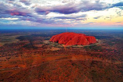
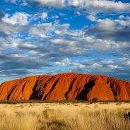
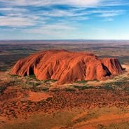
Uluru, Sacred inselberg in Northern Territory, Australia

Description

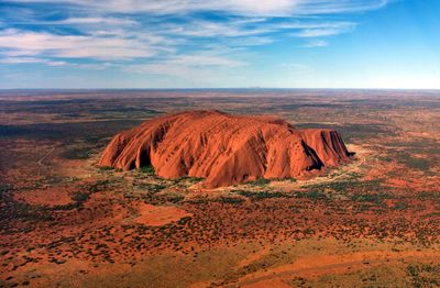
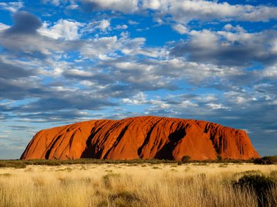
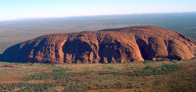
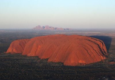
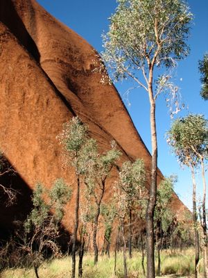
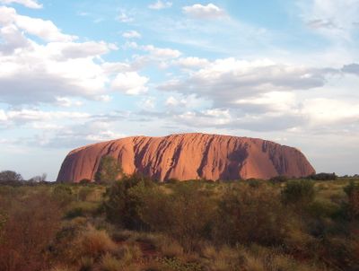
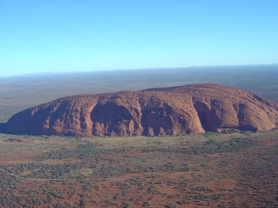
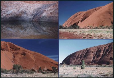
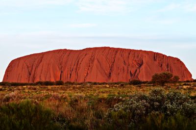
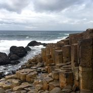
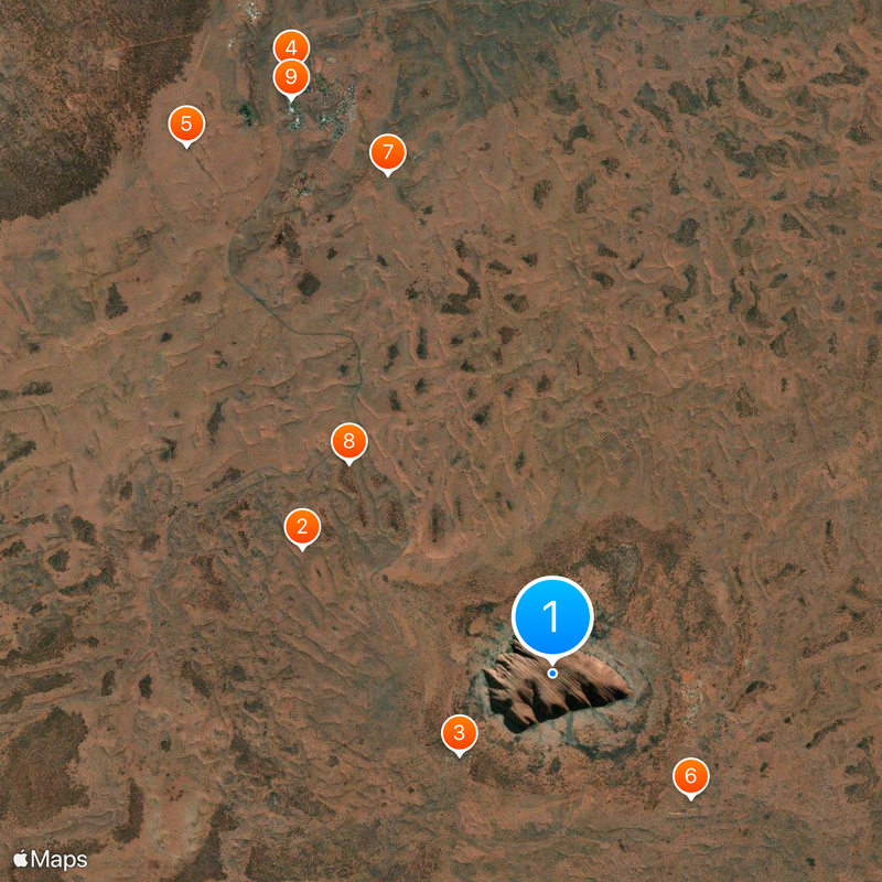
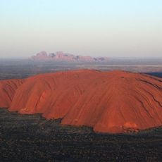
The sandstone monolith rises 1142 feet (348 meters) from surrounding plains with steep flanks and reaches an elevation of 2831 feet (863 meters) above sea level. The surface shows grooves, caves, and weathering patterns formed through thousands of years of erosion, while the base circumference measures about 5.8 miles (9.4 kilometers) with the longest axis running northwest to southeast.

History

The formation began 550 million years ago during the Precambrian era from sediments of ancient river channels. Europeans first documented it in 1873 during a surveying expedition led by William Gosse, and the Australian government returned the land to Anangu owners in 1985, who manage it as a national park and restored the traditional name.

Culture

The Anangu continue ceremonies and care for rock paintings while preserving oral creation stories that see the land as a living being. Some sections remain closed because they hold sacred meaning for traditional rituals and initiation rites, while local families share selected narratives with guests and keep other stories within the community.

Practical

The national park requires visitors to carry enough water supplies and sun protection, as temperatures in summer regularly exceed 104 degrees Fahrenheit (40 degrees Celsius). Rangers offer guided walks at dawn and sunset when heat is more tolerable, while access is via Yulara, located 12 miles (20 kilometers) away, which provides hotels, campsites, and restaurants.

Did you know?

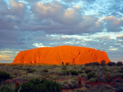
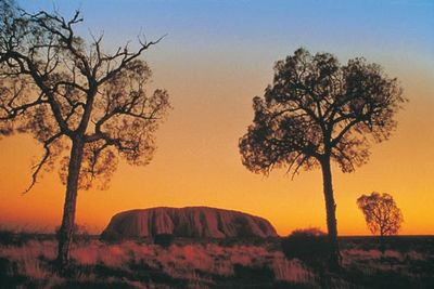
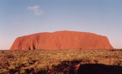
The arkose sandstone composition creates color transformations from brown to red throughout the day through mineral oxidation and light reflection. Rainfall transforms dry watercourses into temporary waterfalls that cascade down the flanks, while geologists have determined that the formation tilts about 1 centimeter per century due to tectonic movements in the region.

Elevation above the sea
863 m
Made from material
arkose
Address
Uluru, Petermann NT 0872, Australia
Opening Hours
Monday-Sunday 07:00-18:00
Phone
GPS coordinates
-25.35977,131.01741
Latest update
January 29, 2026 09:40

AroundUs brings together thousands of curated places, local tips, and hidden gems, enriched daily by 60,000 contributors worldwide. Discover all places nearby (Northern Territory).

The most impressive viewpoints in the world

From the highest peaks to coastal cliffs, this collection brings together geographically significant observation points across all continents. The locations offer views of mountain ranges, waterfalls, deserts, oceans, and notable architectural structures. The selection includes the Great Wall near...

Notable rock formations worldwide

Geological formations develop over millions of years through natural processes including erosion, weathering, and tectonic activity. These rocks and stone structures take various forms – arches, monoliths, spheres, and pillars – shaped by wind, water, and time. They document Earth's geological...

Ancient stone monuments: sacred sites, temples, and structures dating back thousands of years

This collection encompasses ancient stone monuments and sacred sites from across the globe, ranging from the Easter Island Moai to the Great Wall of China. The structures represent millennia of human engineering and include religious temples, fortifications, burial sites, and astronomical...

Australian outback: natural landmarks, geology, desert landscapes

The Australian outback encompasses a vast territory featuring distinctive geological characteristics, including ancient sandstone formations, deep canyons, and expansive salt lakes. This region contains some of Earth's oldest landscapes, from the red monoliths of the Northern Territory to the...

Geological formations and natural wonders on Earth

The Earth offers a wide range of geological shapes shaped over millions of years by weather and the movements of the land. In Northern Ireland, thousands of basalt columns stand along the coast, leftover from an ancient eruption. In Arizona, the Colorado River carved out a canyon more than 400 miles...

Satellite images showing incredible locations seen from the sky

Satellite imagery has transformed how we view remote locations on Earth, offering perspectives on places that are often invisible or difficult to reach from ground level. This collection presents natural formations, artificial structures and historical sites from an aerial vantage point. From...

What to see in the Northern Territory of Australia: natural sites, national parks, and deserts

The Northern Territory in Australia offers landscapes from the wet tropical areas of the Top End to the red stretches of the Red Centre. This collection brings together about thirty sites that show this variety: Darwin, a city facing the sea of Timor, the rock formations of Uluru and Kata Tjuta...

« Uluru - Sacred inselberg in Northern Territory, Australia » is provided by Around Us (aroundus.com). Images and texts are derived from Wikimedia project under a Creative Commons license. You are allowed to copy, distribute, and modify copies of this page, under the conditions set by the license, as long as this note is clearly visible.

Discover hidden gems everywhere you go!

From secret cafés to breathtaking viewpoints, skip the crowded tourist spots and find places that match your style. Our app makes it easy with voice search, smart filtering, route optimization, and insider tips from travelers worldwide. Download now for the complete mobile experience.

Around Us App Screenshot

A unique approach to discovering new places

Le Figaro

All the places worth exploring

France Info

A tailor-made excursion in just a few clicks

20 Minutes

Around Us
Travel Guide & Maps
Download

Send to your phone

QR Code
1

Open the camera app on your mobile.

2

Point at the QR code with your camera. A notification will appear.

3

Tap the notification to open the link.