See the monuments around you in AROpen chests in the app
Around Us is built for your phone — point your camera at the streets and discover the monuments and places around you in augmented reality.Around Us is built for your phone — chests unlock when you walk, explore and capture nearby places.
Satellites reveal hidden landscapes only the sky allows to see: ancient geoglyphs and surprising natural formations. Our planet shows itself in a new light.
Satellite imagery has transformed how we view remote locations on Earth, offering perspectives on places that are often invisible or difficult to reach from ground level. This collection presents natural formations, artificial structures and historical sites from an aerial vantage point. From geological features like the circular Richat Structure in Mauritania's desert to ancient geoglyphs and modern engineering achievements, these images provide a distinct view of our planet's diversity.
Locations documented include the geometric Nazca Lines in Peru, the pyramid structure of El Castillo in Mexico's Yucatán Peninsula and the Badlands Guardian in Alberta, a natural rock formation that resembles a head wearing headphones when seen from above. The collection also features Palm Jumeirah in Dubai, an artificial archipelago shaped like a palm tree, the vivid blue potash evaporation ponds in Utah, the pink waters of Lake Hillier in Western Australia and the volcanic island of Surtsey off Iceland. Additional examples include the Atacama Giant in Chile, a prehistoric geoglyph, the heart shaped Galesnjak island off Croatia's coast and the ship graveyard of the former Aral Sea in Uzbekistan, which documents the ecological consequences of human intervention.
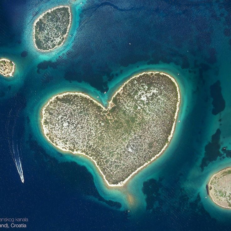
This heart-shaped island in the Adriatic Sea provides an unusual example of natural coastal formations. Galesnjak lies uninhabited off the Dalmatian coast and displays the distinctive outline of a heart in satellite imagery. Dense vegetation covers the entire island surface, while the surrounding waters highlight the characteristic shape clearly.
This clay and sandstone erosion landscape appears from satellite view as a face with traditional feather ornaments, forming a natural geological feature in southeastern Alberta. The Badlands Guardian spans several hundred meters and developed through millennia of weathering in the Canadian Badlands, with its contours only fully visible from above and the human-like features shaped by shadows and erosion channels.
This area in the Coral Sea between Australia and New Caledonia documents a cartographic error that was disproven by a scientific expedition in 2012. Sandy Island appeared on nautical charts and digital mapping services for decades, despite the absence of any landmass at this location. The satellite imagery reveals the actual ocean waters where the island was incorrectly marked on maps.
The Palm Jumeirah is an artificial island group in Dubai constructed from sand fill, forming 16 extensions that create the shape of a palm tree with trunk and fronds when viewed from above, documented through satellite imagery of remote and notable places on Earth.
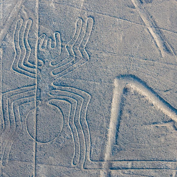
These geometric figures and animal drawings were carved into the desert floor 2,000 years ago and remain visible only from above. The Nazca Lines represent one of the most documented archaeological sites in satellite imagery, demonstrating the technical capabilities of pre-Columbian cultures in creating large-scale geoglyphs across the Peruvian coastal desert through the removal of oxidized surface stones.
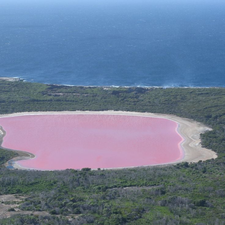
This lake in Western Australia displays pink water caused by microorganisms and algae. Lake Hillier sits on Middle Island, bordered by white salt edges and eucalyptus forests. The satellite image documents the unusual coloration of this saline lake, which remains clearly visible from altitude and creates a contrast with the surrounding vegetation.
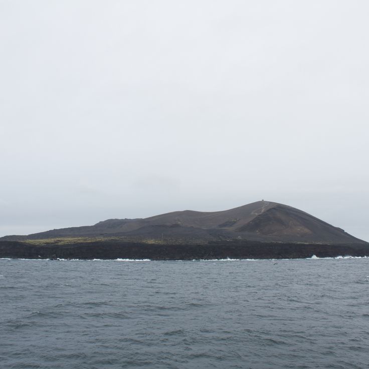
The island of Surtsey emerged between 1963 and 1967 from underwater volcanic eruptions south of Iceland. Since its formation, scientists have used it as an open-air laboratory to study natural colonization by plants, birds and insects. Access remains strictly controlled to preserve research conditions. Satellite imagery in this collection documents the geological formation and tracks vegetation development across the young volcanic terrain.
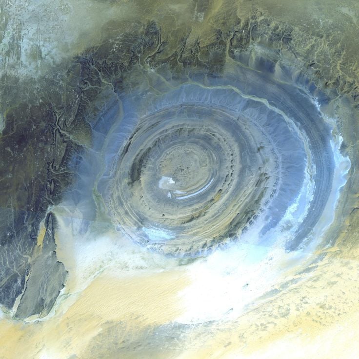
The Richat Structure is a geological formation with concentric rings spanning 25 miles (40 kilometers) in diameter, formed by erosion of a rock dome in northwestern Mauritania. The formation consists of sedimentary rock layers exposed through tectonic uplift and subsequently eroded by wind and water. The characteristic rings reveal different rock types, including sandstone, limestone, and dolomite. This natural structure sits in the Sahara Desert and is primarily visible from aerial or satellite views.
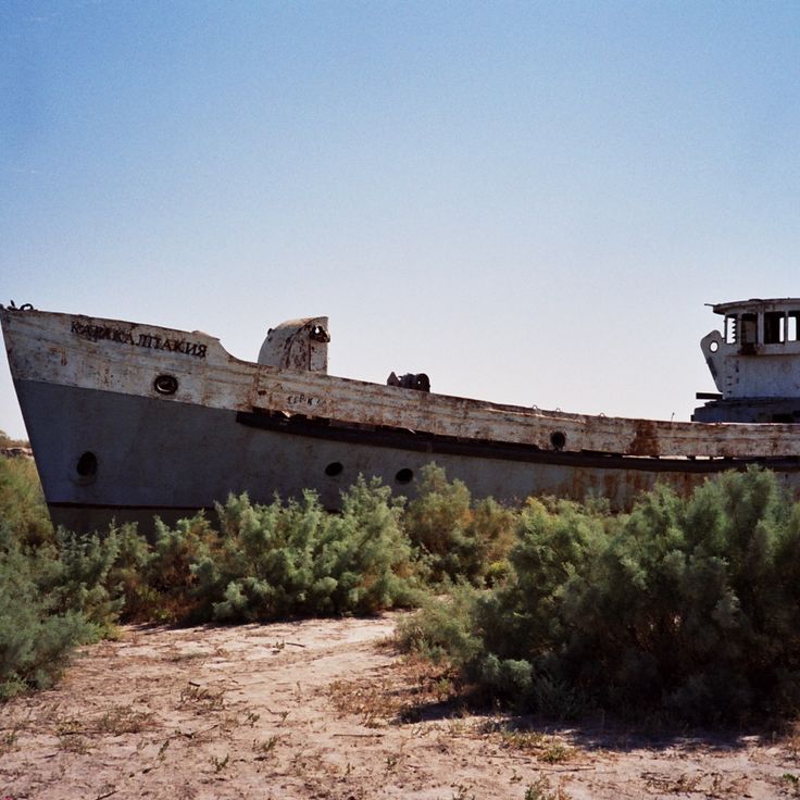
The metal remains of the Moynaq fishing fleet lie scattered in sand where Aral Sea waters once reached. This satellite perspective documents the consequences of the Aral Sea's recession, which was once among the world's largest inland bodies of water. The rusted ship hulls mark the former shoreline and serve as evidence of one of the twentieth century's most significant human-caused environmental disasters.
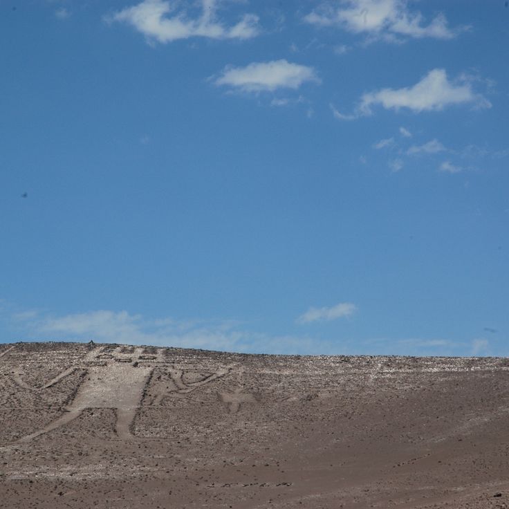
This figure engraved in the sand measures 390 feet (119 meters) and was created by the Tiwanaku cultures. The Atacama Giant ranks among the largest prehistoric representations in the world, showing a human form with geometric details on a desert hillside in northern Chile. The satellite image documents the geoglyphic work, which dates between 1000 and 1400 CE and likely held astronomical or ritual significance.
This Maya step pyramid forms the central structure of the archaeological site and reaches a height of 98 feet (30 meters). El Castillo was built between the 8th and 12th centuries and served as a temple to the feathered serpent god Kukulcán. The satellite imagery in this collection shows the precise geometric arrangement of the structure within the ancient city.
This collection of satellite imagery documents remote locations on Earth through photographs from Google Earth and Google Maps, capturing natural formations, artificial islands, and historical sites. The images show geological structures such as the Richat crater in Mauritania, the Badlands Guardian in Canada, Palm Jumeirah in Dubai, the Nazca Lines in Peru, and El Castillo in Mexico.
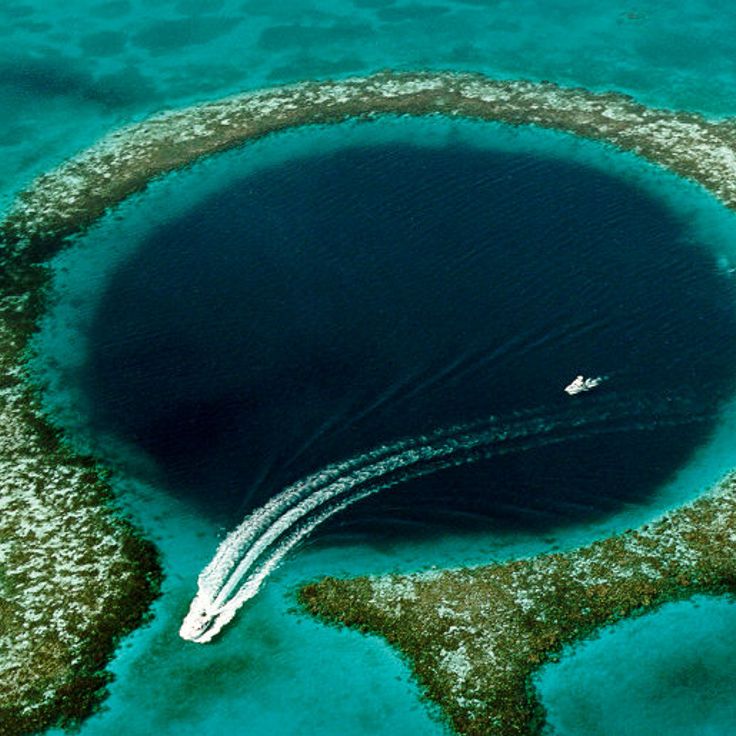
The Great Blue Hole is a circular sinkhole off the coast of Belize, part of the Lighthouse Reef atoll in the Caribbean Sea. This submerged limestone crater measures approximately 1,000 feet (300 meters) across and reaches a depth of 410 feet (125 meters), formed during the last ice age when lower sea levels allowed cave systems to develop. From satellite imagery, the formation appears as a dark blue disc surrounded by the lighter turquoise waters of the surrounding reef, revealing the geological structure of this underwater cave system.
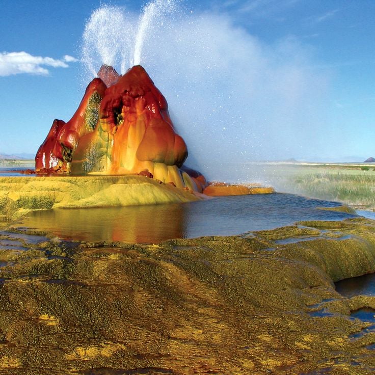
The Fly Geyser is a man-made geothermal formation in Washoe County, Nevada, created in 1964 when a well drilled for geothermal energy was improperly sealed. Water shoots from the source and dissolves minerals from the surrounding rock, depositing them on the surface and forming terraced mounds over the decades. The coloration comes from thermophilic algae and cyanobacteria that thrive in the hot, mineral-rich waters. Located on private property, the geyser is accessible only through guided tours. Viewing this formation from above reveals its full structure and the striking patterns of mineral deposits spreading across the desert floor.
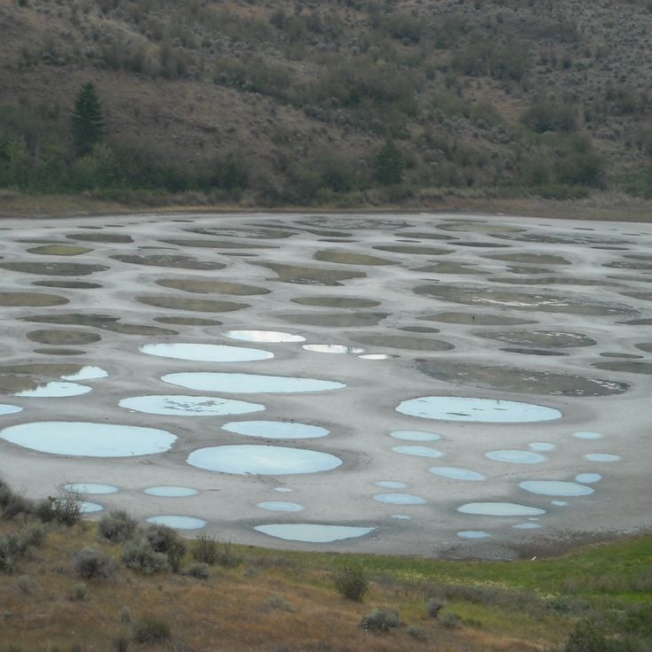
Spotted Lake in British Columbia's Similkameen Valley is an endorheic salt lake whose mineral-rich water evaporates through summer, leaving behind a mosaic of rounded pools in shades of green, yellow and blue. These spots form due to high concentrations of magnesium sulfate, calcium sulfate and sodium sulfate, which create different colors depending on depth and mineral composition. Satellite imagery reveals the geometric pattern of these natural pools, most pronounced during the dry season.
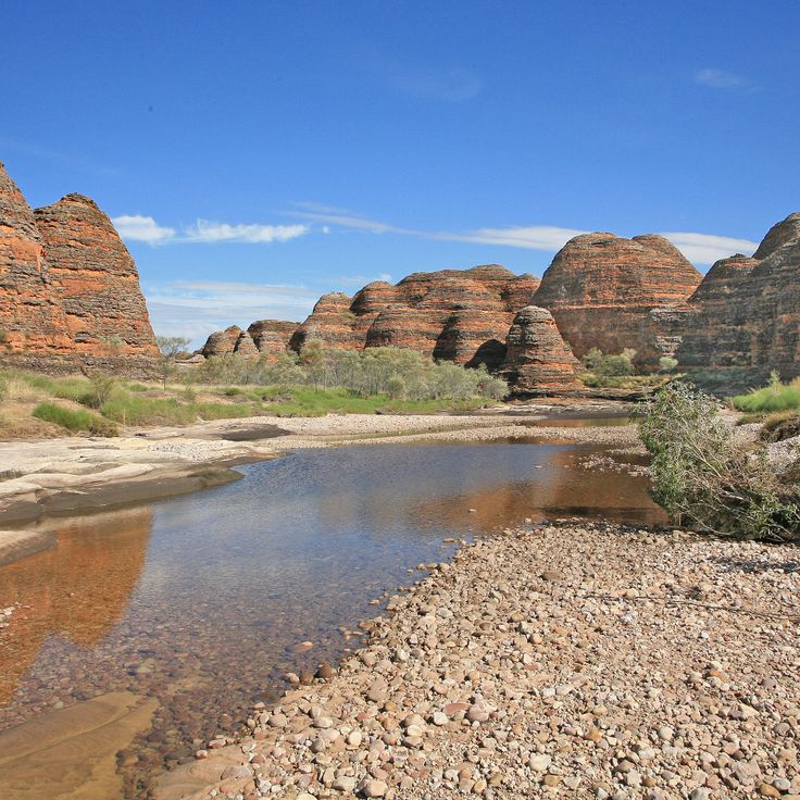
Purnululu National Park occupies the eastern section of the Kimberley region in Western Australia, covering approximately 240,000 hectares of semi-arid landscape. The defining feature of this park is the Bungle Bungle Range, a series of sandstone formations displaying distinctive orange and gray banding created by biological crusts and iron oxides. These geological structures developed over twenty million years and rest on former seabed. The park contains both gorges with seasonal waterways and rock faces bearing Aboriginal rock art. From the satellite perspective, the striped pattern of the Bungle Bungles appears as a pronounced feature of this remote Australian landscape.
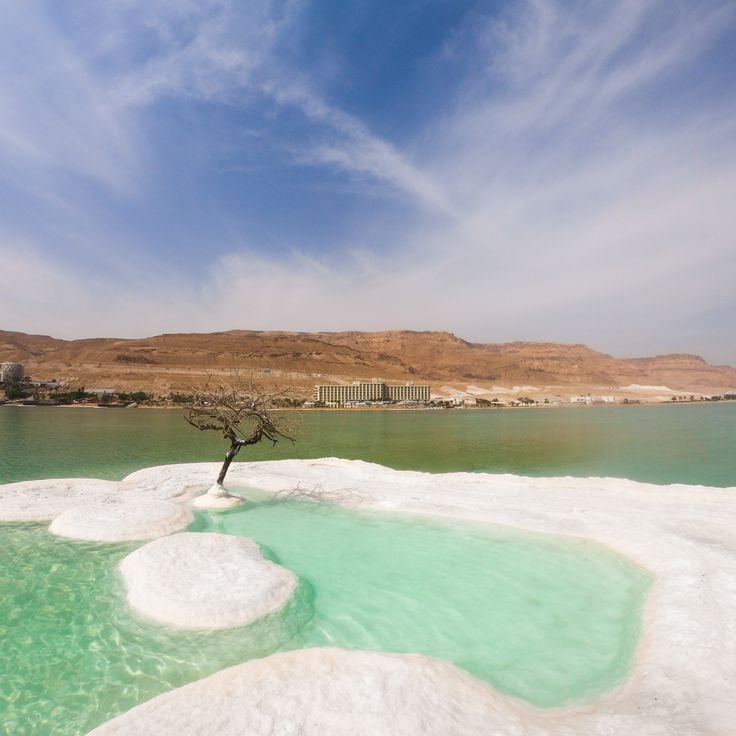
These salt formations along the Dead Sea shore form through the high mineral concentration in the water, which creates crystalline structures as water levels drop. The mushroom-shaped deposits document the ongoing evaporation of this landlocked salt lake between Jordan and Israel, whose water level has been declining for decades. Satellite imagery reveals the white salt accumulations along the coastline, shaped by human water extraction and natural evaporation.
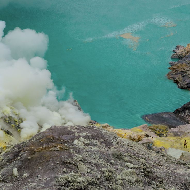
The Kawah Ijen crater lake is an acidic volcanic lake in eastern Java, known for its blue-green color. This satellite image shows one of the most extreme water bodies on Earth, with a pH below 0.5 and a high level of sulfur. The lake sits in the crater of the active Kawah Ijen volcano at about 2300 meters above sea level and covers roughly 36 hectares.
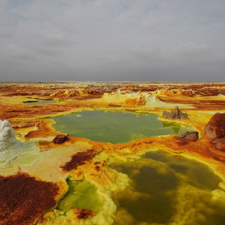
The Danakil Depression sits in the northern section of the East African Rift in Ethiopia's Afar Region. Satellite images show this geological lowland at roughly 410 feet (125 meters) below sea level, formed by tectonic activity at the junction of three tectonic plates. The surface is marked by salt crusts, sulfur deposits and volcanic formations, with temperatures regularly exceeding 122°F (50°C). The area includes the Erta Ale volcano with its persistent lava lake and the colored hydrothermal fields of Dallol, created by mineral-rich springs. This depression documents active geological processes where oceanic crust forms on land.
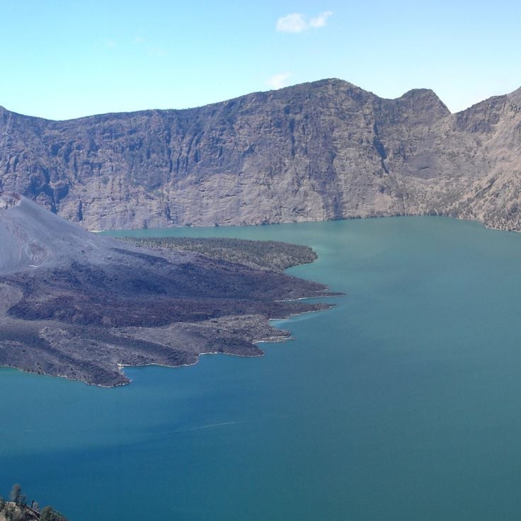
Segara Anak is a crescent-shaped volcano lake in the middle of Mount Rinjani on Lombok. The blue lake is at 2000 meters above sea level in a caldera formed about 13000 years ago by a large volcanic eruption. From the lake, the active volcano cone of Gunung Barujari rises. It erupted in 1994 and 2009. The crater lake is about six kilometers wide and is surrounded by steep walls up to 600 meters tall.
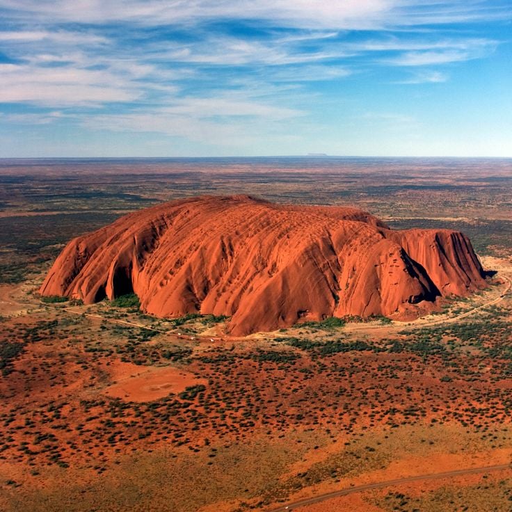
This red sandstone monolith in Australia rises 1,142 feet (348 meters) above the surrounding plains and serves as an important spiritual center for the Anangu, the traditional owners of the region. Uluru covers an area of approximately 1.3 square miles (3.3 square kilometers) and its surface displays erosion-formed grooves, caves and rock overhangs that contain rock art and ceremonial sites. Iron oxide minerals in the rock give the monolith its characteristic reddish coloration, which changes with the hours of daylight and weather conditions.
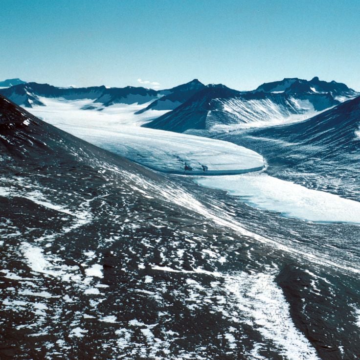
Victoria Valley lies within Antarctica's McMurdo Dry Valleys, one of the driest regions on Earth. From a satellite perspective, this valley reveals a barren, glacier-carved landscape without permanent ice cover. The area serves as a natural laboratory for scientific research, offering insights into extreme environments. The geological formations and absence of vegetation make this Antarctic valley a telling example of places typically difficult to reach from ground level.
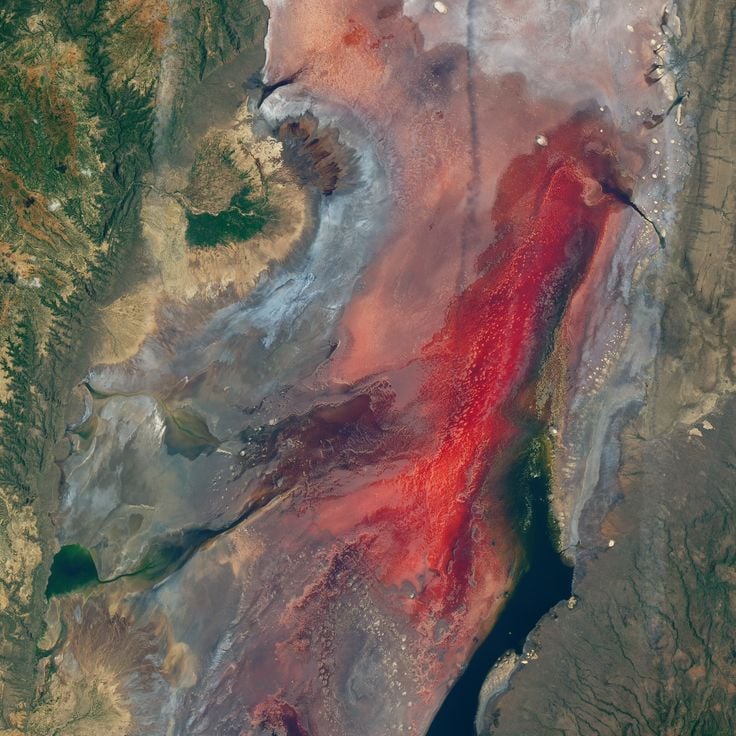
Lake Natron in northern Tanzania extends for 35 miles (56 kilometers) near the border with Kenya. This alkaline lake, with pH levels reaching 10.5, appears in various shades of red and pink on satellite imagery due to cyanobacteria and other microorganisms thriving in its mineral-rich waters. The high concentration of sodium carbonate, derived from volcanic ash from nearby Ol Doinyo Lengai, creates the lake's extreme chemical conditions. This remote lake serves as the primary breeding ground for more than two million lesser flamingos in East Africa, which feed on the algae responsible for the distinctive coloration.
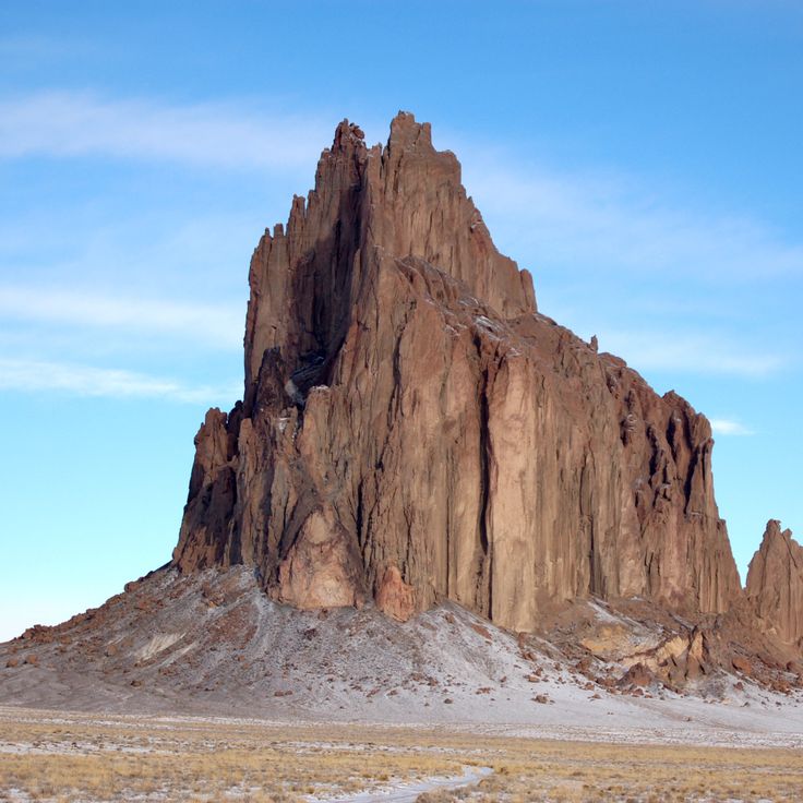
Shiprock is a prominent volcanic plug rising from the desert plain in northwestern New Mexico, part of a larger volcanic complex. This formation was created approximately 27 million years ago and reaches 1,583 feet (482 meters) above the surrounding terrain. For the Navajo Nation, Shiprock carries significant cultural importance and appears in traditional narratives and ceremonies. The satellite imagery captures the rock's distinctive shape and several dikes radiating from the main peak across the surrounding land. The area is closed to the public, but distant views from nearby roads allow visitors to observe this geological structure.
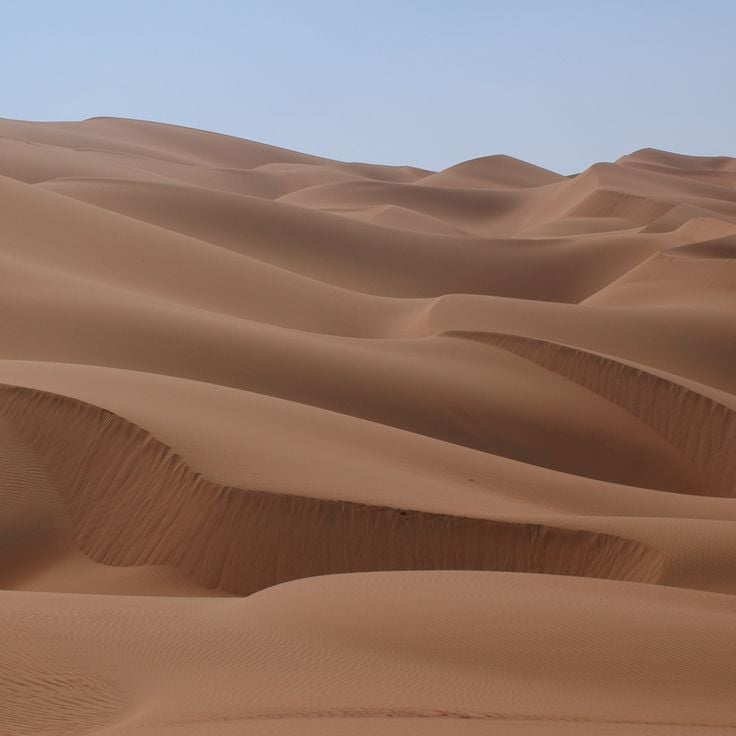
The Rub al-Khali, also known as the Empty Quarter, is the largest continuous sand desert on Earth, covering portions of the southern Arabian Peninsula. Satellite imagery shows the wave-like dune ridges extending for hundreds of miles, along with the characteristic color gradations from pale gold to reddish-brown. This desert spans approximately 250,000 square miles (650,000 square kilometers) and encompasses vast areas without permanent human settlements. The images document an extreme ecosystem where temperatures can exceed 122 degrees Fahrenheit (50 degrees Celsius) and rainfall is scarce.
Kerguelen Islands, French Southern and Antarctic Lands
The Main Land makes up the main island of the Kerguelen Islands in the south of the Indian Ocean, roughly halfway between Madagascar and Antarctica. This volcanic island covers about 6675 square miles (17300 km²) and has rugged terrain with Mount Ross as its highest point at 1850 meters. The steep landscape is the result of repeated volcanic activity, with the latest eruptions happening around 25 million years ago. The Main Land has many glaciers, deep fjords, and coastlines shaped by the wind, which can be seen clearly from space. The island is part of French Southern and Antarctic Lands and has a research station open all year.
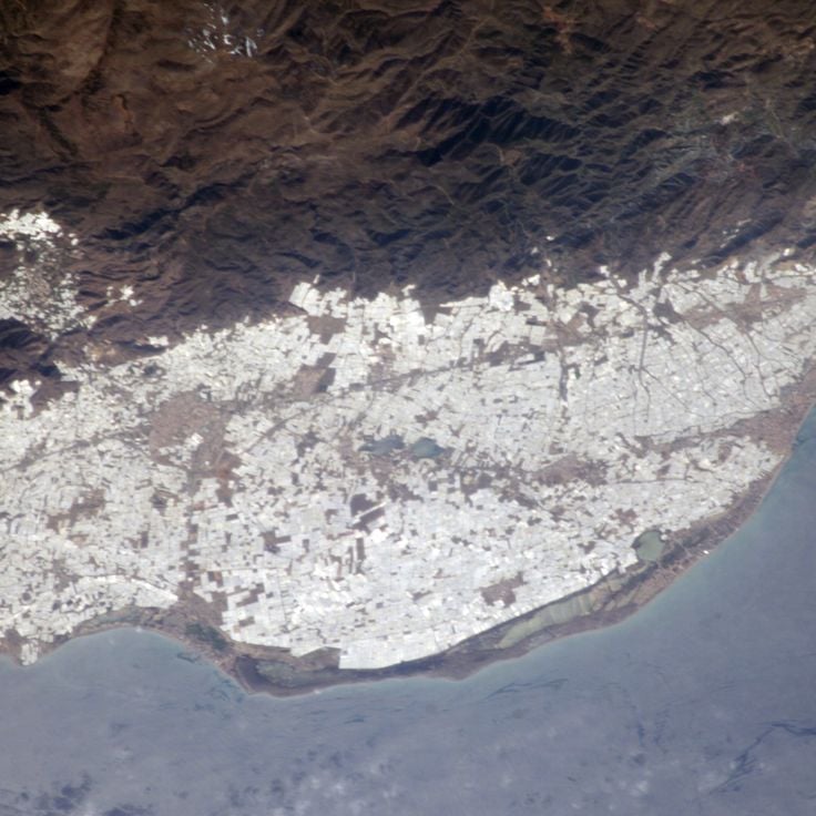
The region around Almería in southern Spain contains one of the world's largest concentrations of greenhouses. These structures cover approximately 76,000 acres (31,000 hectares) and appear as a white expanse when viewed from space. The complex began developing in the 1960s and has transformed the local economy through the cultivation of tomatoes, peppers and cucumbers. The plastic coverings reflect sunlight and create a measurable cooling effect across the region. The area produces roughly 3.5 million tons of vegetables annually and supplies a substantial portion of winter produce to European markets. This satellite perspective documents the effects of intensive agricultural development on what was originally arid terrain.
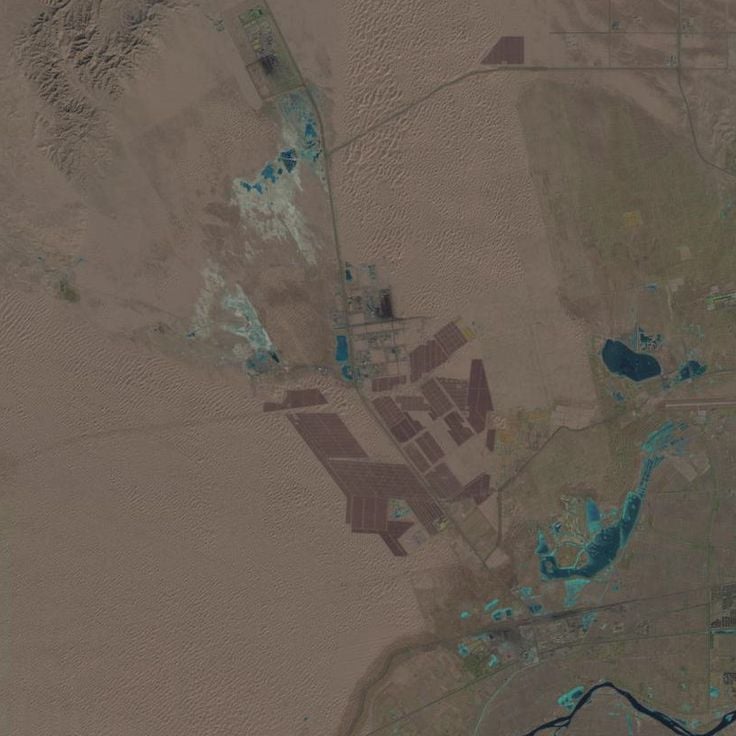
The Tengger Desert Solar Park covers an area of 17 square miles (43 square kilometers) in the Tengger Desert, harnessing one of China's sunniest regions for power generation. From space, the scale of this installation becomes apparent, with millions of solar panels arranged in regular rows stretching across the desert terrain. The facility was built in phases starting in 2012 and ranks among the largest solar energy installations worldwide. The contrasting image of dark blue panels against light desert sand illustrates the dimensions of this renewable energy project in an otherwise uninhabited area.
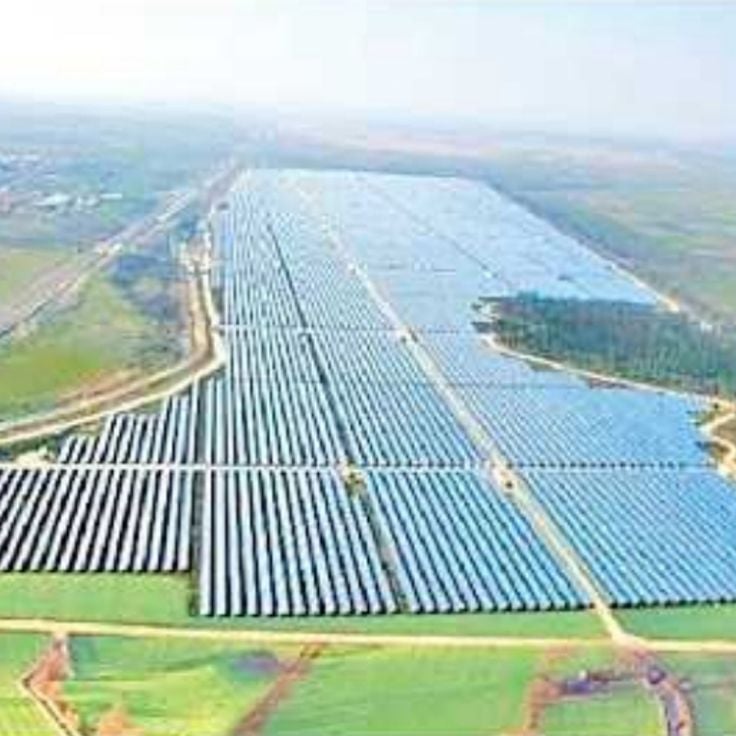
The Pavagada Solar Park in Karnataka consists of a series of photovoltaic installations spanning approximately 20 square miles (53 square kilometers) with an installed capacity of 2,050 megawatts. Commissioned in 2018, the project was developed on land leased from farmers across five villages and ranks among the largest solar parks globally. The facility supplies electricity to the state grid and demonstrates Indian renewable energy infrastructure in a region with intense solar radiation.
The Banaue rice terraces were carved into the mountain slopes of the province of Ifugao more than 2000 years ago and cover about 10360 square kilometers. These farming structures follow the natural shape of the land and form a staged system of plots fed by an irrigation network that draws water from nearby forests. From an aerial view, these terraces show geometric patterns that match the land's shape and illustrate how local communities changed farming practices to suit difficult terrain.
The Mir Mine in Mirny is one of the world's largest open-pit diamond mines, measuring approximately 1200 meters (3937 feet) in diameter and more than 525 meters (1722 feet) deep. This circular pit was developed during the Soviet era and extracted diamonds through open-pit operations until 2001, when mining shifted underground. From space, the mine displays a distinctive spiral pattern with terraced roads winding along the crater walls.
This copper mine in northern Utah ranks among the largest man-made excavations in the world. Open-pit mining stretches four miles wide and reaches about 4,000 feet deep, with benches visible from space. Since opening in 1906, the mine has produced over 19 million tons of copper as well as large amounts of gold, silver, and molybdenum, making it one of the most productive mining operations in North America.
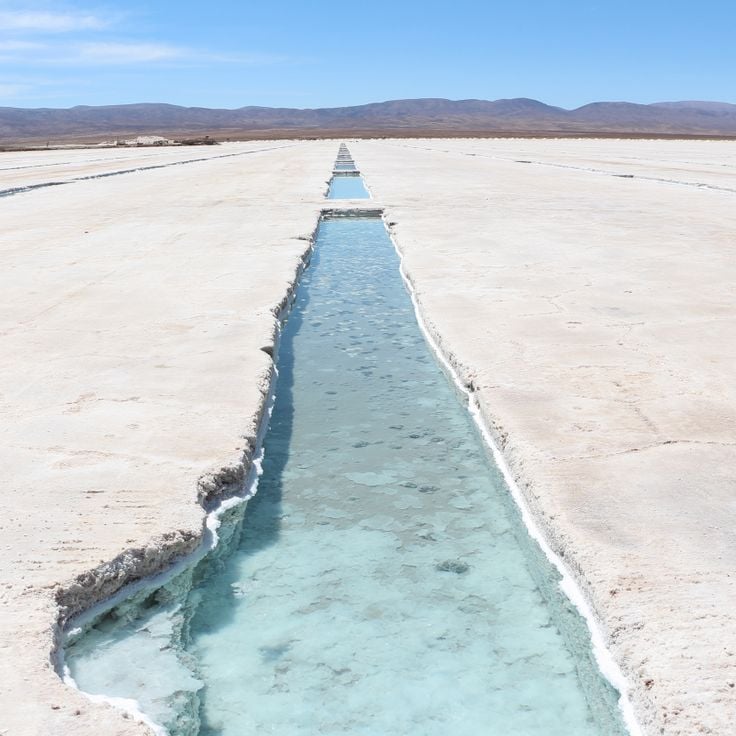
These terraced salt pools near the village of Maras in the Sacred Valley have been used for salt production since pre-Columbian times. The network of over 3000 shallow evaporation ponds fills with mineral-rich water from an underground spring flowing down the mountain. The salt remaining after evaporation is still harvested today by local families who have been working these ponds for generations. From above, the salt pans form a pattern of brown, pink, and white rectangles that change with the water level and salt concentration. The site is about 3000 meters high and surrounded by mountain peaks.
The Salinas Grandes is an extensive salt flat spanning Argentina's Buenos Aires and La Pampa provinces, displaying distinctive geometric patterns when viewed from above. From a satellite perspective, this salt desert reveals polygonal formations created by the evaporation of mineral-rich water. The bright, reflective surfaces contrast sharply with the surrounding Pampa landscape and document the natural processes occurring in endorheic basins. This formation represents one of many geological and human-altered landscapes that reveal their full spatial organization only from an aerial vantage point.
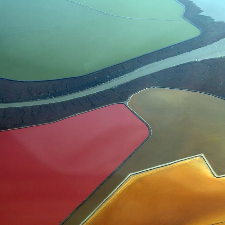
These salt evaporation ponds in San Francisco Bay between Redwood City and Newark display varying shades of orange, red and green caused by different microorganisms and algae populations thriving at different salinity levels. The facility uses solar evaporation to extract salt from the bay's seawater, with water flowing through a series of ponds that become progressively more concentrated. Salt production in San Francisco Bay has a history spanning more than 150 years and reached its peak in the 1930s when roughly one third of the salt consumed in the United States came from this region.
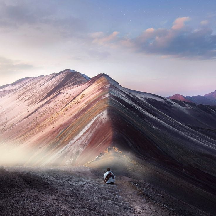
Vinicunca formed through tectonic activity and mineral deposits that colored sedimentary layers with iron oxides, sulfur compounds and other elements. This geological formation sits at approximately 17,000 feet (5,200 meters) elevation in the Peruvian Andes and displays horizontal bands of red, yellow and green tones. Satellite images document the erosion patterns and extent of these colored rock layers in the Cusco region, exposed through weathering and high-altitude climate conditions.
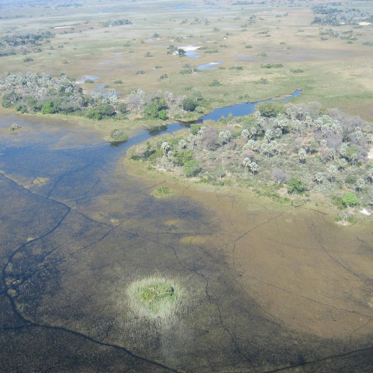
The Okavango Delta spreads across roughly 5,800 square miles (15,000 square kilometers) in northern Botswana, forming an inland delta where the waters of the Okavango River do not reach the ocean but instead drain into the Kalahari Desert. This endorheic system creates a seasonally shifting wetland with permanent swamp areas and floodplains that reach their maximum extent during the annual flood period between May and September. Satellites capture the delta's characteristic channels, islands and vegetation, which support concentrations of wildlife. UNESCO designated the area as a World Heritage Site in 2014 for its geological and ecological significance.
The Niger Delta covers about 70,000 square miles along Nigeria's southern coast. It is one of the largest wetland areas on the continent. Satellite images show branched waterways and sediment deposits built up over many years as the Niger flows to the sea. The delta has mangrove forests, seasonal flood zones, and many channels. These channels hold oil deposits and supply water to millions of people.
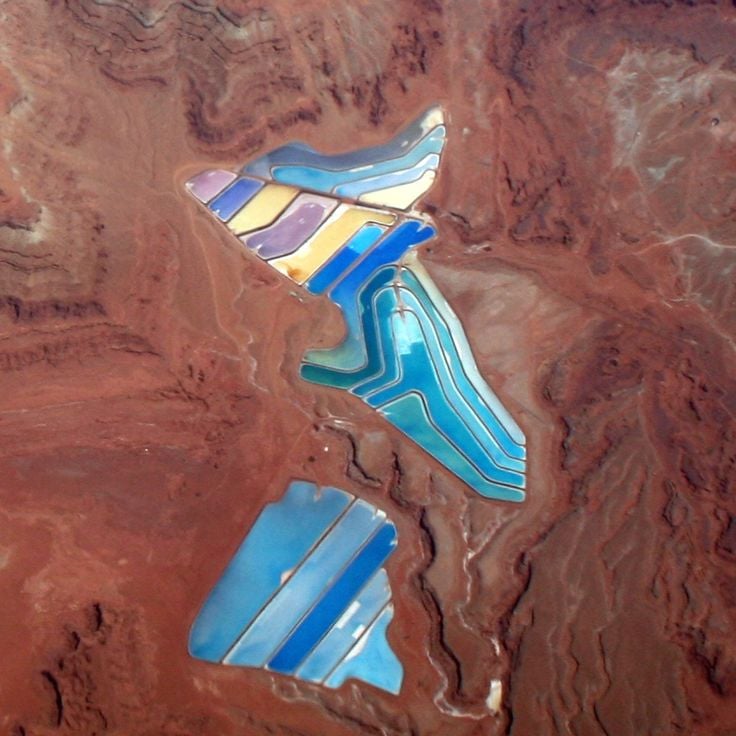
These industrial basins extract potassium salts through evaporation. Minerals and microorganisms in the water create the distinctive coloring of Potash Ponds. The Utah facility uses natural evaporation processes to extract usable potassium compounds from salt solutions. From above, the basins appear as geometric patterns with intense blue and turquoise tones.
This heart-shaped island in the Adriatic Sea provides an unusual example of natural coastal formations. Galesnjak lies uninhabited off the Dalmatian coast and displays the distinctive outline of a heart in satellite imagery. Dense vegetation covers the entire island surface, while the surrounding waters highlight the characteristic shape clearly.
This clay and sandstone erosion landscape appears from satellite view as a face with traditional feather ornaments, forming a natural geological feature in southeastern Alberta. The Badlands Guardian spans several hundred meters and developed through millennia of weathering in the Canadian Badlands, with its contours only fully visible from above and the human-like features shaped by shadows and erosion channels.
This area in the Coral Sea between Australia and New Caledonia documents a cartographic error that was disproven by a scientific expedition in 2012. Sandy Island appeared on nautical charts and digital mapping services for decades, despite the absence of any landmass at this location. The satellite imagery reveals the actual ocean waters where the island was incorrectly marked on maps.
The Palm Jumeirah is an artificial island group in Dubai constructed from sand fill, forming 16 extensions that create the shape of a palm tree with trunk and fronds when viewed from above, documented through satellite imagery of remote and notable places on Earth.
These geometric figures and animal drawings were carved into the desert floor 2,000 years ago and remain visible only from above. The Nazca Lines represent one of the most documented archaeological sites in satellite imagery, demonstrating the technical capabilities of pre-Columbian cultures in creating large-scale geoglyphs across the Peruvian coastal desert through the removal of oxidized surface stones.
This lake in Western Australia displays pink water caused by microorganisms and algae. Lake Hillier sits on Middle Island, bordered by white salt edges and eucalyptus forests. The satellite image documents the unusual coloration of this saline lake, which remains clearly visible from altitude and creates a contrast with the surrounding vegetation.
The island of Surtsey emerged between 1963 and 1967 from underwater volcanic eruptions south of Iceland. Since its formation, scientists have used it as an open-air laboratory to study natural colonization by plants, birds and insects. Access remains strictly controlled to preserve research conditions. Satellite imagery in this collection documents the geological formation and tracks vegetation development across the young volcanic terrain.
The Richat Structure is a geological formation with concentric rings spanning 25 miles (40 kilometers) in diameter, formed by erosion of a rock dome in northwestern Mauritania. The formation consists of sedimentary rock layers exposed through tectonic uplift and subsequently eroded by wind and water. The characteristic rings reveal different rock types, including sandstone, limestone, and dolomite. This natural structure sits in the Sahara Desert and is primarily visible from aerial or satellite views.
The metal remains of the Moynaq fishing fleet lie scattered in sand where Aral Sea waters once reached. This satellite perspective documents the consequences of the Aral Sea's recession, which was once among the world's largest inland bodies of water. The rusted ship hulls mark the former shoreline and serve as evidence of one of the twentieth century's most significant human-caused environmental disasters.
This figure engraved in the sand measures 390 feet (119 meters) and was created by the Tiwanaku cultures. The Atacama Giant ranks among the largest prehistoric representations in the world, showing a human form with geometric details on a desert hillside in northern Chile. The satellite image documents the geoglyphic work, which dates between 1000 and 1400 CE and likely held astronomical or ritual significance.
This Maya step pyramid forms the central structure of the archaeological site and reaches a height of 98 feet (30 meters). El Castillo was built between the 8th and 12th centuries and served as a temple to the feathered serpent god Kukulcán. The satellite imagery in this collection shows the precise geometric arrangement of the structure within the ancient city.
This collection of satellite imagery documents remote locations on Earth through photographs from Google Earth and Google Maps, capturing natural formations, artificial islands, and historical sites. The images show geological structures such as the Richat crater in Mauritania, the Badlands Guardian in Canada, Palm Jumeirah in Dubai, the Nazca Lines in Peru, and El Castillo in Mexico.
The Great Blue Hole is a circular sinkhole off the coast of Belize, part of the Lighthouse Reef atoll in the Caribbean Sea. This submerged limestone crater measures approximately 1,000 feet (300 meters) across and reaches a depth of 410 feet (125 meters), formed during the last ice age when lower sea levels allowed cave systems to develop. From satellite imagery, the formation appears as a dark blue disc surrounded by the lighter turquoise waters of the surrounding reef, revealing the geological structure of this underwater cave system.
The Fly Geyser is a man-made geothermal formation in Washoe County, Nevada, created in 1964 when a well drilled for geothermal energy was improperly sealed. Water shoots from the source and dissolves minerals from the surrounding rock, depositing them on the surface and forming terraced mounds over the decades. The coloration comes from thermophilic algae and cyanobacteria that thrive in the hot, mineral-rich waters. Located on private property, the geyser is accessible only through guided tours. Viewing this formation from above reveals its full structure and the striking patterns of mineral deposits spreading across the desert floor.
Spotted Lake in British Columbia's Similkameen Valley is an endorheic salt lake whose mineral-rich water evaporates through summer, leaving behind a mosaic of rounded pools in shades of green, yellow and blue. These spots form due to high concentrations of magnesium sulfate, calcium sulfate and sodium sulfate, which create different colors depending on depth and mineral composition. Satellite imagery reveals the geometric pattern of these natural pools, most pronounced during the dry season.
Purnululu National Park occupies the eastern section of the Kimberley region in Western Australia, covering approximately 240,000 hectares of semi-arid landscape. The defining feature of this park is the Bungle Bungle Range, a series of sandstone formations displaying distinctive orange and gray banding created by biological crusts and iron oxides. These geological structures developed over twenty million years and rest on former seabed. The park contains both gorges with seasonal waterways and rock faces bearing Aboriginal rock art. From the satellite perspective, the striped pattern of the Bungle Bungles appears as a pronounced feature of this remote Australian landscape.
These salt formations along the Dead Sea shore form through the high mineral concentration in the water, which creates crystalline structures as water levels drop. The mushroom-shaped deposits document the ongoing evaporation of this landlocked salt lake between Jordan and Israel, whose water level has been declining for decades. Satellite imagery reveals the white salt accumulations along the coastline, shaped by human water extraction and natural evaporation.
The Kawah Ijen crater lake is an acidic volcanic lake in eastern Java, known for its blue-green color. This satellite image shows one of the most extreme water bodies on Earth, with a pH below 0.5 and a high level of sulfur. The lake sits in the crater of the active Kawah Ijen volcano at about 2300 meters above sea level and covers roughly 36 hectares.
The Danakil Depression sits in the northern section of the East African Rift in Ethiopia's Afar Region. Satellite images show this geological lowland at roughly 410 feet (125 meters) below sea level, formed by tectonic activity at the junction of three tectonic plates. The surface is marked by salt crusts, sulfur deposits and volcanic formations, with temperatures regularly exceeding 122°F (50°C). The area includes the Erta Ale volcano with its persistent lava lake and the colored hydrothermal fields of Dallol, created by mineral-rich springs. This depression documents active geological processes where oceanic crust forms on land.
Segara Anak is a crescent-shaped volcano lake in the middle of Mount Rinjani on Lombok. The blue lake is at 2000 meters above sea level in a caldera formed about 13000 years ago by a large volcanic eruption. From the lake, the active volcano cone of Gunung Barujari rises. It erupted in 1994 and 2009. The crater lake is about six kilometers wide and is surrounded by steep walls up to 600 meters tall.
This red sandstone monolith in Australia rises 1,142 feet (348 meters) above the surrounding plains and serves as an important spiritual center for the Anangu, the traditional owners of the region. Uluru covers an area of approximately 1.3 square miles (3.3 square kilometers) and its surface displays erosion-formed grooves, caves and rock overhangs that contain rock art and ceremonial sites. Iron oxide minerals in the rock give the monolith its characteristic reddish coloration, which changes with the hours of daylight and weather conditions.
Victoria Valley lies within Antarctica's McMurdo Dry Valleys, one of the driest regions on Earth. From a satellite perspective, this valley reveals a barren, glacier-carved landscape without permanent ice cover. The area serves as a natural laboratory for scientific research, offering insights into extreme environments. The geological formations and absence of vegetation make this Antarctic valley a telling example of places typically difficult to reach from ground level.
Lake Natron in northern Tanzania extends for 35 miles (56 kilometers) near the border with Kenya. This alkaline lake, with pH levels reaching 10.5, appears in various shades of red and pink on satellite imagery due to cyanobacteria and other microorganisms thriving in its mineral-rich waters. The high concentration of sodium carbonate, derived from volcanic ash from nearby Ol Doinyo Lengai, creates the lake's extreme chemical conditions. This remote lake serves as the primary breeding ground for more than two million lesser flamingos in East Africa, which feed on the algae responsible for the distinctive coloration.
Shiprock is a prominent volcanic plug rising from the desert plain in northwestern New Mexico, part of a larger volcanic complex. This formation was created approximately 27 million years ago and reaches 1,583 feet (482 meters) above the surrounding terrain. For the Navajo Nation, Shiprock carries significant cultural importance and appears in traditional narratives and ceremonies. The satellite imagery captures the rock's distinctive shape and several dikes radiating from the main peak across the surrounding land. The area is closed to the public, but distant views from nearby roads allow visitors to observe this geological structure.
The Rub al-Khali, also known as the Empty Quarter, is the largest continuous sand desert on Earth, covering portions of the southern Arabian Peninsula. Satellite imagery shows the wave-like dune ridges extending for hundreds of miles, along with the characteristic color gradations from pale gold to reddish-brown. This desert spans approximately 250,000 square miles (650,000 square kilometers) and encompasses vast areas without permanent human settlements. The images document an extreme ecosystem where temperatures can exceed 122 degrees Fahrenheit (50 degrees Celsius) and rainfall is scarce.
Kerguelen Islands, French Southern and Antarctic Lands
The Main Land makes up the main island of the Kerguelen Islands in the south of the Indian Ocean, roughly halfway between Madagascar and Antarctica. This volcanic island covers about 6675 square miles (17300 km²) and has rugged terrain with Mount Ross as its highest point at 1850 meters. The steep landscape is the result of repeated volcanic activity, with the latest eruptions happening around 25 million years ago. The Main Land has many glaciers, deep fjords, and coastlines shaped by the wind, which can be seen clearly from space. The island is part of French Southern and Antarctic Lands and has a research station open all year.
The region around Almería in southern Spain contains one of the world's largest concentrations of greenhouses. These structures cover approximately 76,000 acres (31,000 hectares) and appear as a white expanse when viewed from space. The complex began developing in the 1960s and has transformed the local economy through the cultivation of tomatoes, peppers and cucumbers. The plastic coverings reflect sunlight and create a measurable cooling effect across the region. The area produces roughly 3.5 million tons of vegetables annually and supplies a substantial portion of winter produce to European markets. This satellite perspective documents the effects of intensive agricultural development on what was originally arid terrain.
The Tengger Desert Solar Park covers an area of 17 square miles (43 square kilometers) in the Tengger Desert, harnessing one of China's sunniest regions for power generation. From space, the scale of this installation becomes apparent, with millions of solar panels arranged in regular rows stretching across the desert terrain. The facility was built in phases starting in 2012 and ranks among the largest solar energy installations worldwide. The contrasting image of dark blue panels against light desert sand illustrates the dimensions of this renewable energy project in an otherwise uninhabited area.
The Pavagada Solar Park in Karnataka consists of a series of photovoltaic installations spanning approximately 20 square miles (53 square kilometers) with an installed capacity of 2,050 megawatts. Commissioned in 2018, the project was developed on land leased from farmers across five villages and ranks among the largest solar parks globally. The facility supplies electricity to the state grid and demonstrates Indian renewable energy infrastructure in a region with intense solar radiation.
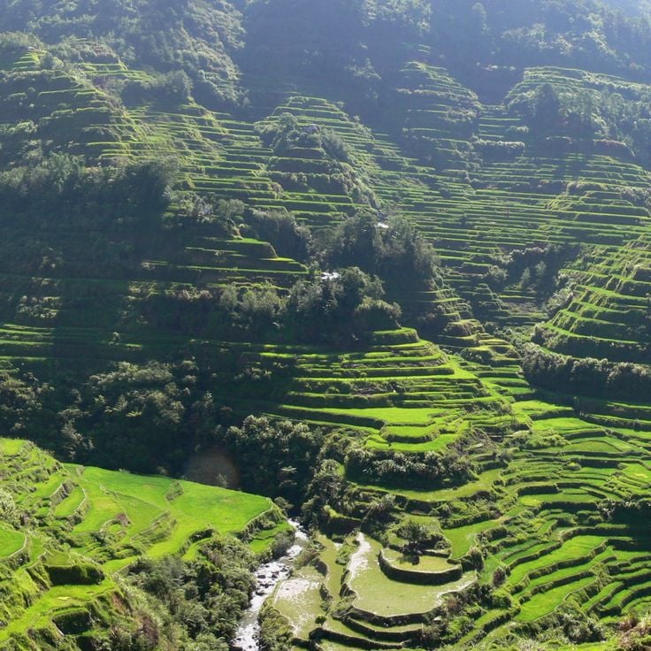
The Banaue rice terraces were carved into the mountain slopes of the province of Ifugao more than 2000 years ago and cover about 10360 square kilometers. These farming structures follow the natural shape of the land and form a staged system of plots fed by an irrigation network that draws water from nearby forests. From an aerial view, these terraces show geometric patterns that match the land's shape and illustrate how local communities changed farming practices to suit difficult terrain.
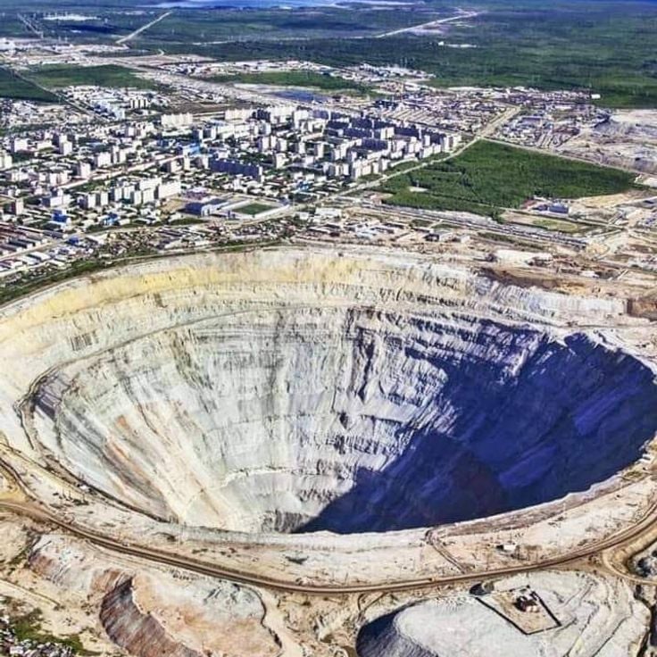
The Mir Mine in Mirny is one of the world's largest open-pit diamond mines, measuring approximately 1200 meters (3937 feet) in diameter and more than 525 meters (1722 feet) deep. This circular pit was developed during the Soviet era and extracted diamonds through open-pit operations until 2001, when mining shifted underground. From space, the mine displays a distinctive spiral pattern with terraced roads winding along the crater walls.
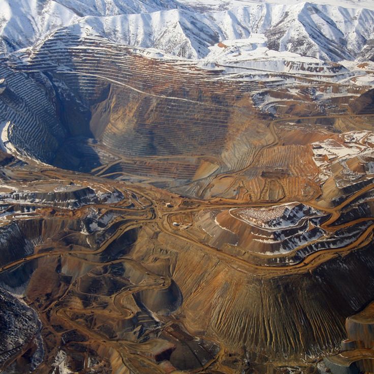
This copper mine in northern Utah ranks among the largest man-made excavations in the world. Open-pit mining stretches four miles wide and reaches about 4,000 feet deep, with benches visible from space. Since opening in 1906, the mine has produced over 19 million tons of copper as well as large amounts of gold, silver, and molybdenum, making it one of the most productive mining operations in North America.
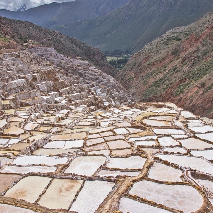
These terraced salt pools near the village of Maras in the Sacred Valley have been used for salt production since pre-Columbian times. The network of over 3000 shallow evaporation ponds fills with mineral-rich water from an underground spring flowing down the mountain. The salt remaining after evaporation is still harvested today by local families who have been working these ponds for generations. From above, the salt pans form a pattern of brown, pink, and white rectangles that change with the water level and salt concentration. The site is about 3000 meters high and surrounded by mountain peaks.
The Salinas Grandes is an extensive salt flat spanning Argentina's Buenos Aires and La Pampa provinces, displaying distinctive geometric patterns when viewed from above. From a satellite perspective, this salt desert reveals polygonal formations created by the evaporation of mineral-rich water. The bright, reflective surfaces contrast sharply with the surrounding Pampa landscape and document the natural processes occurring in endorheic basins. This formation represents one of many geological and human-altered landscapes that reveal their full spatial organization only from an aerial vantage point.
These salt evaporation ponds in San Francisco Bay between Redwood City and Newark display varying shades of orange, red and green caused by different microorganisms and algae populations thriving at different salinity levels. The facility uses solar evaporation to extract salt from the bay's seawater, with water flowing through a series of ponds that become progressively more concentrated. Salt production in San Francisco Bay has a history spanning more than 150 years and reached its peak in the 1930s when roughly one third of the salt consumed in the United States came from this region.
Vinicunca formed through tectonic activity and mineral deposits that colored sedimentary layers with iron oxides, sulfur compounds and other elements. This geological formation sits at approximately 17,000 feet (5,200 meters) elevation in the Peruvian Andes and displays horizontal bands of red, yellow and green tones. Satellite images document the erosion patterns and extent of these colored rock layers in the Cusco region, exposed through weathering and high-altitude climate conditions.
The Okavango Delta spreads across roughly 5,800 square miles (15,000 square kilometers) in northern Botswana, forming an inland delta where the waters of the Okavango River do not reach the ocean but instead drain into the Kalahari Desert. This endorheic system creates a seasonally shifting wetland with permanent swamp areas and floodplains that reach their maximum extent during the annual flood period between May and September. Satellites capture the delta's characteristic channels, islands and vegetation, which support concentrations of wildlife. UNESCO designated the area as a World Heritage Site in 2014 for its geological and ecological significance.
The Niger Delta covers about 70,000 square miles along Nigeria's southern coast. It is one of the largest wetland areas on the continent. Satellite images show branched waterways and sediment deposits built up over many years as the Niger flows to the sea. The delta has mangrove forests, seasonal flood zones, and many channels. These channels hold oil deposits and supply water to millions of people.
These industrial basins extract potassium salts through evaporation. Minerals and microorganisms in the water create the distinctive coloring of Potash Ponds. The Utah facility uses natural evaporation processes to extract usable potassium compounds from salt solutions. From above, the basins appear as geometric patterns with intense blue and turquoise tones.
This heart-shaped island in the Adriatic Sea provides an unusual example of natural coastal formations. Galesnjak lies uninhabited off the Dalmatian coast and displays the distinctive outline of a heart in satellite imagery. Dense vegetation covers the entire island surface, while the surrounding waters highlight the characteristic shape clearly.
This clay and sandstone erosion landscape appears from satellite view as a face with traditional feather ornaments, forming a natural geological feature in southeastern Alberta. The Badlands Guardian spans several hundred meters and developed through millennia of weathering in the Canadian Badlands, with its contours only fully visible from above and the human-like features shaped by shadows and erosion channels.
This area in the Coral Sea between Australia and New Caledonia documents a cartographic error that was disproven by a scientific expedition in 2012. Sandy Island appeared on nautical charts and digital mapping services for decades, despite the absence of any landmass at this location. The satellite imagery reveals the actual ocean waters where the island was incorrectly marked on maps.
The Palm Jumeirah is an artificial island group in Dubai constructed from sand fill, forming 16 extensions that create the shape of a palm tree with trunk and fronds when viewed from above, documented through satellite imagery of remote and notable places on Earth.
These geometric figures and animal drawings were carved into the desert floor 2,000 years ago and remain visible only from above. The Nazca Lines represent one of the most documented archaeological sites in satellite imagery, demonstrating the technical capabilities of pre-Columbian cultures in creating large-scale geoglyphs across the Peruvian coastal desert through the removal of oxidized surface stones.
This lake in Western Australia displays pink water caused by microorganisms and algae. Lake Hillier sits on Middle Island, bordered by white salt edges and eucalyptus forests. The satellite image documents the unusual coloration of this saline lake, which remains clearly visible from altitude and creates a contrast with the surrounding vegetation.
The island of Surtsey emerged between 1963 and 1967 from underwater volcanic eruptions south of Iceland. Since its formation, scientists have used it as an open-air laboratory to study natural colonization by plants, birds and insects. Access remains strictly controlled to preserve research conditions. Satellite imagery in this collection documents the geological formation and tracks vegetation development across the young volcanic terrain.
The Richat Structure is a geological formation with concentric rings spanning 25 miles (40 kilometers) in diameter, formed by erosion of a rock dome in northwestern Mauritania. The formation consists of sedimentary rock layers exposed through tectonic uplift and subsequently eroded by wind and water. The characteristic rings reveal different rock types, including sandstone, limestone, and dolomite. This natural structure sits in the Sahara Desert and is primarily visible from aerial or satellite views.
The metal remains of the Moynaq fishing fleet lie scattered in sand where Aral Sea waters once reached. This satellite perspective documents the consequences of the Aral Sea's recession, which was once among the world's largest inland bodies of water. The rusted ship hulls mark the former shoreline and serve as evidence of one of the twentieth century's most significant human-caused environmental disasters.
This figure engraved in the sand measures 390 feet (119 meters) and was created by the Tiwanaku cultures. The Atacama Giant ranks among the largest prehistoric representations in the world, showing a human form with geometric details on a desert hillside in northern Chile. The satellite image documents the geoglyphic work, which dates between 1000 and 1400 CE and likely held astronomical or ritual significance.
This Maya step pyramid forms the central structure of the archaeological site and reaches a height of 98 feet (30 meters). El Castillo was built between the 8th and 12th centuries and served as a temple to the feathered serpent god Kukulcán. The satellite imagery in this collection shows the precise geometric arrangement of the structure within the ancient city.
This collection of satellite imagery documents remote locations on Earth through photographs from Google Earth and Google Maps, capturing natural formations, artificial islands, and historical sites. The images show geological structures such as the Richat crater in Mauritania, the Badlands Guardian in Canada, Palm Jumeirah in Dubai, the Nazca Lines in Peru, and El Castillo in Mexico.
The Great Blue Hole is a circular sinkhole off the coast of Belize, part of the Lighthouse Reef atoll in the Caribbean Sea. This submerged limestone crater measures approximately 1,000 feet (300 meters) across and reaches a depth of 410 feet (125 meters), formed during the last ice age when lower sea levels allowed cave systems to develop. From satellite imagery, the formation appears as a dark blue disc surrounded by the lighter turquoise waters of the surrounding reef, revealing the geological structure of this underwater cave system.
The Fly Geyser is a man-made geothermal formation in Washoe County, Nevada, created in 1964 when a well drilled for geothermal energy was improperly sealed. Water shoots from the source and dissolves minerals from the surrounding rock, depositing them on the surface and forming terraced mounds over the decades. The coloration comes from thermophilic algae and cyanobacteria that thrive in the hot, mineral-rich waters. Located on private property, the geyser is accessible only through guided tours. Viewing this formation from above reveals its full structure and the striking patterns of mineral deposits spreading across the desert floor.
Spotted Lake in British Columbia's Similkameen Valley is an endorheic salt lake whose mineral-rich water evaporates through summer, leaving behind a mosaic of rounded pools in shades of green, yellow and blue. These spots form due to high concentrations of magnesium sulfate, calcium sulfate and sodium sulfate, which create different colors depending on depth and mineral composition. Satellite imagery reveals the geometric pattern of these natural pools, most pronounced during the dry season.
Purnululu National Park occupies the eastern section of the Kimberley region in Western Australia, covering approximately 240,000 hectares of semi-arid landscape. The defining feature of this park is the Bungle Bungle Range, a series of sandstone formations displaying distinctive orange and gray banding created by biological crusts and iron oxides. These geological structures developed over twenty million years and rest on former seabed. The park contains both gorges with seasonal waterways and rock faces bearing Aboriginal rock art. From the satellite perspective, the striped pattern of the Bungle Bungles appears as a pronounced feature of this remote Australian landscape.
These salt formations along the Dead Sea shore form through the high mineral concentration in the water, which creates crystalline structures as water levels drop. The mushroom-shaped deposits document the ongoing evaporation of this landlocked salt lake between Jordan and Israel, whose water level has been declining for decades. Satellite imagery reveals the white salt accumulations along the coastline, shaped by human water extraction and natural evaporation.
The Kawah Ijen crater lake is an acidic volcanic lake in eastern Java, known for its blue-green color. This satellite image shows one of the most extreme water bodies on Earth, with a pH below 0.5 and a high level of sulfur. The lake sits in the crater of the active Kawah Ijen volcano at about 2300 meters above sea level and covers roughly 36 hectares.
The Danakil Depression sits in the northern section of the East African Rift in Ethiopia's Afar Region. Satellite images show this geological lowland at roughly 410 feet (125 meters) below sea level, formed by tectonic activity at the junction of three tectonic plates. The surface is marked by salt crusts, sulfur deposits and volcanic formations, with temperatures regularly exceeding 122°F (50°C). The area includes the Erta Ale volcano with its persistent lava lake and the colored hydrothermal fields of Dallol, created by mineral-rich springs. This depression documents active geological processes where oceanic crust forms on land.
Segara Anak is a crescent-shaped volcano lake in the middle of Mount Rinjani on Lombok. The blue lake is at 2000 meters above sea level in a caldera formed about 13000 years ago by a large volcanic eruption. From the lake, the active volcano cone of Gunung Barujari rises. It erupted in 1994 and 2009. The crater lake is about six kilometers wide and is surrounded by steep walls up to 600 meters tall.
This red sandstone monolith in Australia rises 1,142 feet (348 meters) above the surrounding plains and serves as an important spiritual center for the Anangu, the traditional owners of the region. Uluru covers an area of approximately 1.3 square miles (3.3 square kilometers) and its surface displays erosion-formed grooves, caves and rock overhangs that contain rock art and ceremonial sites. Iron oxide minerals in the rock give the monolith its characteristic reddish coloration, which changes with the hours of daylight and weather conditions.
Victoria Valley lies within Antarctica's McMurdo Dry Valleys, one of the driest regions on Earth. From a satellite perspective, this valley reveals a barren, glacier-carved landscape without permanent ice cover. The area serves as a natural laboratory for scientific research, offering insights into extreme environments. The geological formations and absence of vegetation make this Antarctic valley a telling example of places typically difficult to reach from ground level.
Lake Natron in northern Tanzania extends for 35 miles (56 kilometers) near the border with Kenya. This alkaline lake, with pH levels reaching 10.5, appears in various shades of red and pink on satellite imagery due to cyanobacteria and other microorganisms thriving in its mineral-rich waters. The high concentration of sodium carbonate, derived from volcanic ash from nearby Ol Doinyo Lengai, creates the lake's extreme chemical conditions. This remote lake serves as the primary breeding ground for more than two million lesser flamingos in East Africa, which feed on the algae responsible for the distinctive coloration.
Shiprock is a prominent volcanic plug rising from the desert plain in northwestern New Mexico, part of a larger volcanic complex. This formation was created approximately 27 million years ago and reaches 1,583 feet (482 meters) above the surrounding terrain. For the Navajo Nation, Shiprock carries significant cultural importance and appears in traditional narratives and ceremonies. The satellite imagery captures the rock's distinctive shape and several dikes radiating from the main peak across the surrounding land. The area is closed to the public, but distant views from nearby roads allow visitors to observe this geological structure.
The Rub al-Khali, also known as the Empty Quarter, is the largest continuous sand desert on Earth, covering portions of the southern Arabian Peninsula. Satellite imagery shows the wave-like dune ridges extending for hundreds of miles, along with the characteristic color gradations from pale gold to reddish-brown. This desert spans approximately 250,000 square miles (650,000 square kilometers) and encompasses vast areas without permanent human settlements. The images document an extreme ecosystem where temperatures can exceed 122 degrees Fahrenheit (50 degrees Celsius) and rainfall is scarce.
Kerguelen Islands, French Southern and Antarctic Lands
The Main Land makes up the main island of the Kerguelen Islands in the south of the Indian Ocean, roughly halfway between Madagascar and Antarctica. This volcanic island covers about 6675 square miles (17300 km²) and has rugged terrain with Mount Ross as its highest point at 1850 meters. The steep landscape is the result of repeated volcanic activity, with the latest eruptions happening around 25 million years ago. The Main Land has many glaciers, deep fjords, and coastlines shaped by the wind, which can be seen clearly from space. The island is part of French Southern and Antarctic Lands and has a research station open all year.
The region around Almería in southern Spain contains one of the world's largest concentrations of greenhouses. These structures cover approximately 76,000 acres (31,000 hectares) and appear as a white expanse when viewed from space. The complex began developing in the 1960s and has transformed the local economy through the cultivation of tomatoes, peppers and cucumbers. The plastic coverings reflect sunlight and create a measurable cooling effect across the region. The area produces roughly 3.5 million tons of vegetables annually and supplies a substantial portion of winter produce to European markets. This satellite perspective documents the effects of intensive agricultural development on what was originally arid terrain.
The Tengger Desert Solar Park covers an area of 17 square miles (43 square kilometers) in the Tengger Desert, harnessing one of China's sunniest regions for power generation. From space, the scale of this installation becomes apparent, with millions of solar panels arranged in regular rows stretching across the desert terrain. The facility was built in phases starting in 2012 and ranks among the largest solar energy installations worldwide. The contrasting image of dark blue panels against light desert sand illustrates the dimensions of this renewable energy project in an otherwise uninhabited area.
The Pavagada Solar Park in Karnataka consists of a series of photovoltaic installations spanning approximately 20 square miles (53 square kilometers) with an installed capacity of 2,050 megawatts. Commissioned in 2018, the project was developed on land leased from farmers across five villages and ranks among the largest solar parks globally. The facility supplies electricity to the state grid and demonstrates Indian renewable energy infrastructure in a region with intense solar radiation.
The Banaue rice terraces were carved into the mountain slopes of the province of Ifugao more than 2000 years ago and cover about 10360 square kilometers. These farming structures follow the natural shape of the land and form a staged system of plots fed by an irrigation network that draws water from nearby forests. From an aerial view, these terraces show geometric patterns that match the land's shape and illustrate how local communities changed farming practices to suit difficult terrain.
The Mir Mine in Mirny is one of the world's largest open-pit diamond mines, measuring approximately 1200 meters (3937 feet) in diameter and more than 525 meters (1722 feet) deep. This circular pit was developed during the Soviet era and extracted diamonds through open-pit operations until 2001, when mining shifted underground. From space, the mine displays a distinctive spiral pattern with terraced roads winding along the crater walls.
This copper mine in northern Utah ranks among the largest man-made excavations in the world. Open-pit mining stretches four miles wide and reaches about 4,000 feet deep, with benches visible from space. Since opening in 1906, the mine has produced over 19 million tons of copper as well as large amounts of gold, silver, and molybdenum, making it one of the most productive mining operations in North America.
These terraced salt pools near the village of Maras in the Sacred Valley have been used for salt production since pre-Columbian times. The network of over 3000 shallow evaporation ponds fills with mineral-rich water from an underground spring flowing down the mountain. The salt remaining after evaporation is still harvested today by local families who have been working these ponds for generations. From above, the salt pans form a pattern of brown, pink, and white rectangles that change with the water level and salt concentration. The site is about 3000 meters high and surrounded by mountain peaks.
The Salinas Grandes is an extensive salt flat spanning Argentina's Buenos Aires and La Pampa provinces, displaying distinctive geometric patterns when viewed from above. From a satellite perspective, this salt desert reveals polygonal formations created by the evaporation of mineral-rich water. The bright, reflective surfaces contrast sharply with the surrounding Pampa landscape and document the natural processes occurring in endorheic basins. This formation represents one of many geological and human-altered landscapes that reveal their full spatial organization only from an aerial vantage point.
These salt evaporation ponds in San Francisco Bay between Redwood City and Newark display varying shades of orange, red and green caused by different microorganisms and algae populations thriving at different salinity levels. The facility uses solar evaporation to extract salt from the bay's seawater, with water flowing through a series of ponds that become progressively more concentrated. Salt production in San Francisco Bay has a history spanning more than 150 years and reached its peak in the 1930s when roughly one third of the salt consumed in the United States came from this region.
Vinicunca formed through tectonic activity and mineral deposits that colored sedimentary layers with iron oxides, sulfur compounds and other elements. This geological formation sits at approximately 17,000 feet (5,200 meters) elevation in the Peruvian Andes and displays horizontal bands of red, yellow and green tones. Satellite images document the erosion patterns and extent of these colored rock layers in the Cusco region, exposed through weathering and high-altitude climate conditions.
The Okavango Delta spreads across roughly 5,800 square miles (15,000 square kilometers) in northern Botswana, forming an inland delta where the waters of the Okavango River do not reach the ocean but instead drain into the Kalahari Desert. This endorheic system creates a seasonally shifting wetland with permanent swamp areas and floodplains that reach their maximum extent during the annual flood period between May and September. Satellites capture the delta's characteristic channels, islands and vegetation, which support concentrations of wildlife. UNESCO designated the area as a World Heritage Site in 2014 for its geological and ecological significance.
The Niger Delta covers about 70,000 square miles along Nigeria's southern coast. It is one of the largest wetland areas on the continent. Satellite images show branched waterways and sediment deposits built up over many years as the Niger flows to the sea. The delta has mangrove forests, seasonal flood zones, and many channels. These channels hold oil deposits and supply water to millions of people.
These industrial basins extract potassium salts through evaporation. Minerals and microorganisms in the water create the distinctive coloring of Potash Ponds. The Utah facility uses natural evaporation processes to extract usable potassium compounds from salt solutions. From above, the basins appear as geometric patterns with intense blue and turquoise tones.
Looking at the Earth from above changes how we understand the world. These satellite images show what we never see on the ground: shapes carved thousands of years ago, colors from water chemistry, and human structures changing the land. Next time you look at an aerial photo, take a moment to find the details. You will see that our planet tells interesting stories when viewed from the sky.