Tigertail Beach

Log in to your account

AroundUs is a community-driven map of interesting places, built by curious explorers like you. It grows with every review, story, and photo you share.
Connect to save your favorite spots, contribute locations, and create personalized routes.
Continue with Google
Continue with Apple
Continue with X
Continue with Facebook
Continue with email
By continuing, you accept our Terms and Conditions and our Privacy Policy
Create an account

Tigertail Beach

Add to collection
Map
Suggest a change
Share

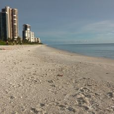
Tigertail Beach, Public beach park in Marco Island, United States

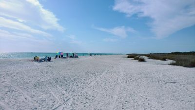
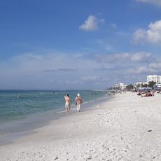
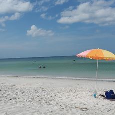
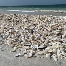
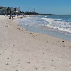
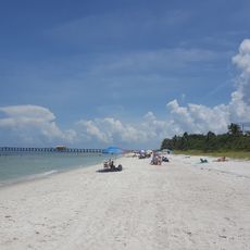
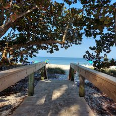
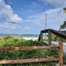
Tigertail Beach is a public beach park on Marco Island featuring a tidal lagoon system that connects an inner beach to an outer shoreline of white sand spanning three miles. The park offers restrooms, showers, picnic areas, and a playground available daily from sunrise until dusk.

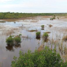
This location was reshaped by Hurricane Wilma in 2005, which connected an offshore sandbar to Marco Island's mainland. The storm's powerful impact created the unique beach formation that exists today.

The beach serves as a stopover for migratory birds and nesting shorebirds, making it a gathering place where visitors naturally encounter eagles, ospreys, terns, and plovers. Birdwatching has become woven into the daily experience of many who spend time here.

The park opens at 8:00 AM and stays open until sunset every day, with facilities spread across both beach sections. To reach the outer beach, you will need to wade through the lagoon at the right tide level, so check tidal conditions before you go.

Reaching the outer section known as Sand Dollar Beach requires wading through a saltwater lagoon at low tide, which is an unusual feature that creates a natural barrier. This transitional experience separates the busier inner beach from the quieter outer shore.

Location: Marco Island

Address: Tigertail Beach, 430 Hernando Dr, Marco Island, FL 34145, USA

Opening Hours: 8:00-sunset

Phone: +12392524000

Website: https://colliercountyfl.gov/your-government/divisions-f-r/parks-and-recreation/beaches-and-boats/marco-island-beaches

GPS coordinates: 25.94834,-81.74288

Latest update: December 13, 2025 17:09

Photos
Around this place
Cape Romano Dome House
United States of America

Cape Romano Dome House

13 km
Naples Zoo
United States of America

Naples Zoo

24.9 km
Picayune Strand State Forest
United States of America

Picayune Strand State Forest

26.7 km
Naples Botanical Garden
United States of America

Naples Botanical Garden

17.9 km
Marriott Beach
United States of America

Marriott Beach

2.3 km
Lowdermilk Beach
United States of America

Lowdermilk Beach

24.8 km
Collier-Seminole State Park
United States of America

Collier-Seminole State Park

14.2 km
Palm Cottage
United States of America

Palm Cottage

21.3 km
Ten Thousand Islands National Wildlife Refuge
United States of America

Ten Thousand Islands National Wildlife Refuge

18.1 km
Naples Historic District
United States of America

Naples Historic District

21.5 km
Marco Island Historical Museum
United States of America

Marco Island Historical Museum

3.2 km
Capt. John Foley Horr House
United States of America

Capt. John Foley Horr House

7.5 km
Bay City Walking Dredge
United States of America

Bay City Walking Dredge

15.7 km
Revs Institute, Inc.
United States of America

Revs Institute, Inc.

24 km
Naples Trolley Tours
United States of America

Naples Trolley Tours

22 km
Naples Depot Museum
United States of America

Naples Depot Museum

22.2 km
Via Miramar Beach
United States of America

Via Miramar Beach

26.6 km
Naples Train Museum
United States of America

Naples Train Museum

22.2 km
Hideaway Beach
United States of America

Hideaway Beach

2 km
Seagate Beach Club
United States of America

Seagate Beach Club

29.8 km
Morgan Beach
United States of America

Morgan Beach

11.5 km
2nd Avenue North Beach
United States of America

2nd Avenue North Beach

23.2 km
16th Avenue South Beach
United States of America

16th Avenue South Beach

20.9 km
15th Avenue South Beach
United States of America

15th Avenue South Beach

21 km
11th Avenue South Beach
United States of America

11th Avenue South Beach

21.6 km
18th Avenue South Beach
United States of America

18th Avenue South Beach

20.6 km
Vedado Way Beach
United States of America

Vedado Way Beach

27.5 km
Naples Pier
United States of America

Naples Pier

21.4 km
Show the full map
Reviews

Visited this place? Tap the stars to rate it and share your experience / photos with the community! Try now! You can cancel it anytime.

« Tigertail Beach - Public beach park in Marco Island, United States » is provided by Around Us (aroundus.com). Images and texts are derived from Wikimedia project under a Creative Commons license. You are allowed to copy, distribute, and modify copies of this page, under the conditions set by the license, as long as this note is clearly visible.

Discover hidden gems everywhere you go!

From secret cafés to breathtaking viewpoints, skip the crowded tourist spots and find places that match your style. Our app makes it easy with voice search, smart filtering, route optimization, and insider tips from travelers worldwide. Download now for the complete mobile experience.

Around Us App Screenshot

A unique approach to discovering new places

Le Figaro

All the places worth exploring

France Info

A tailor-made excursion in just a few clicks

20 Minutes