Parque Natural da Ribeira dos Caldeirões

Log in to your account

AroundUs is a community-driven map of interesting places, built by curious explorers like you. It grows with every review, story, and photo you share.
Connect to save your favorite spots, contribute locations, and create personalized routes.
By continuing, you accept our Terms and Conditions and our Privacy Policy

Parque Natural da Ribeira dos Caldeirões

Add to collection
Map
Suggest a change
Share

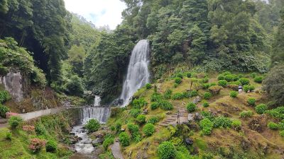
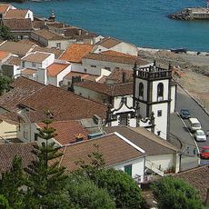
Parque Natural da Ribeira dos Caldeirões, Natural park with waterfalls and mills in Achada, Portugal

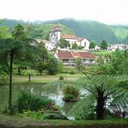
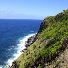
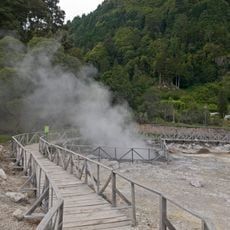
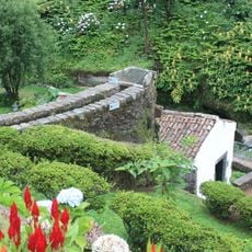
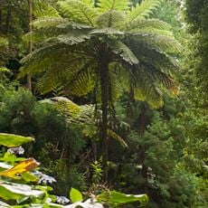
Parque Natural da Ribeira dos Caldeirões is a protected nature reserve featuring several waterfalls, five water mills, and walking paths through native island vegetation. The park's layout descends into a valley where mills sit beside flowing streams, with pools and cascades distributed throughout the forested landscape.

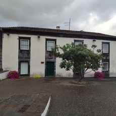
The five mills date back to the 16th century and operated without interruption until modern times, grinding grain for local families. These structures were passed down through generations and anchored the region's agricultural life for centuries.

The name refers to the cauldron-shaped rock pools carved by flowing water over centuries. Visitors can observe how locals once harnessed water power and understand the role these mills played in the island's daily rhythms.

Entry is free and the park provides parking, restrooms, and picnic facilities with tables. Paths can be steep and slippery, especially after rain, so wear good shoes and allow extra time for walking carefully through the terrain.

One mill remains operational and demonstrates how grain was once ground by water power. A craft center within the park showcases traditional processing techniques that connect visitors directly to the island's agricultural past.

Location: Achada

Address: Estrada Regional

GPS coordinates: 37.84323,-25.26855

Latest update: December 6, 2025 17:41

Azores: volcanic nature, botanical gardens and island heritage

The Azores archipelago is located approximately 930 miles (1500 km) off the coast of Portugal in the Atlantic. The volcanic origin of the nine islands has shaped a landscape featuring crater lakes, active hot springs, caves carved into the rock, and botanical gardens arranged around geothermal basins. São Miguel hosts many of these sites, including Parque Terra Nostra in Furnas with its 102°F (39°C) ferruginous pools, the Fogo Lake at 1,887 meters (6,191 ft) above sea level, and the Gorreana tea plantation, operating since 1883. The archipelago also features geological formations accessible to visitors, such as Algar do Carvão on Terceira, descending 90 meters (295 feet) underground, and Vila Franca do Campo, an old crater now a lagoon. Pico's vineyards, listed as a UNESCO World Heritage Site, demonstrate agricultural adaptation to volcanic terrain. Beyond natural sights, several religious and civil buildings dating from the 16th century remain in historic towns, notably in Angra do Heroísmo on Terceira.

Reviews

Visited this place? Tap the stars to rate it and share your experience / photos with the community! Try now! You can cancel it anytime.

« Parque Natural da Ribeira dos Caldeirões - Natural park with waterfalls and mills in Achada, Portugal » is provided by Around Us (aroundus.com). Images and texts are derived from Wikimedia project under a Creative Commons license. You are allowed to copy, distribute, and modify copies of this page, under the conditions set by the license, as long as this note is clearly visible.

Discover hidden gems everywhere you go!

From secret cafés to breathtaking viewpoints, skip the crowded tourist spots and find places that match your style. Our app makes it easy with voice search, smart filtering, route optimization, and insider tips from travelers worldwide. Download now for the complete mobile experience.

Around Us App Screenshot

A unique approach to discovering new places

Le Figaro

All the places worth exploring

France Info

A tailor-made excursion in just a few clicks

20 Minutes