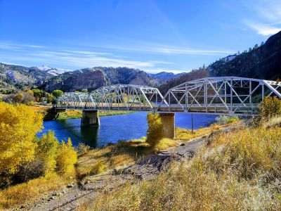
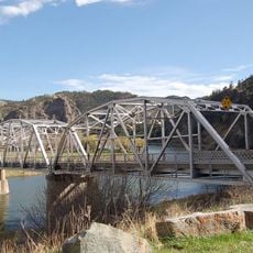
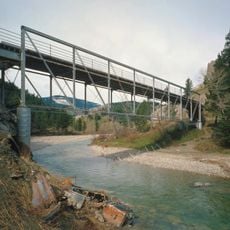
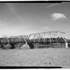
Hardy Bridge

Log in to your account

AroundUs is a community-driven map of interesting places, built by curious explorers like you. It grows with every review, story, and photo you share.
Connect to save your favorite spots, contribute locations, and create personalized routes.
By continuing, you accept our Terms and Conditions and our Privacy Policy
Add to collection
Map
Suggest a change
Share

Hardy Bridge

Hardy Bridge is a simple crossing that spans the Missouri River in Cascade and provides nearby boat launch access. Built in 1931, the structure features straightforward design and continues to serve local transportation and recreational needs today.

Hardy Bridge was constructed in 1931 during a period when similar bridges were built throughout Montana. In 2010, it was added to the National Register of Historic Places, acknowledging its role in the state's transportation history.

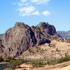
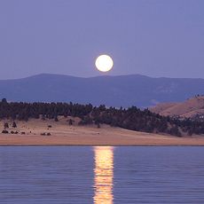
Hardy Bridge serves as a gathering point for the local community centered on river activities and outdoor pursuits. Fishing and boating define the daily culture here, where people connect with the water and landscape as part of their regular rhythm.

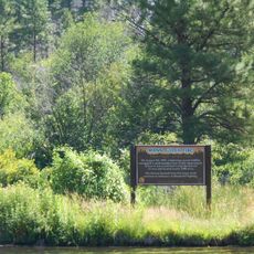
Access to the river requires crossing railroad tracks, a routine part of the visitor route to the water. A nearby fishing access area offers restroom facilities and space for trailers, accommodating day visitors and overnight stays.

Fly fishermen favor the location for pursuing large brown trout, particularly during early morning and late afternoon hours. The straightforward structure provides a stable vantage point for observing the quiet river valley and surrounding landscape.

Location: Cascade

Address: Cascade, MT 59421, USA

GPS coordinates: 47.16700,-111.83440

Latest update: December 10, 2025 14:04

Photos
Unusual Montana: natural sites, historic landmarks, and craft distilleries

Montana hosts natural and historic sites ranging from the limestone gorges of Bighorn Canyon, where red cliffs rise over 300 meters, to the Makoshika badlands dotted with dinosaur fossils. Visitors explore the boiling River near Gardiner, where thermal springs blend with the cold waters of the...

Around this place
Show the full map
Hauser Dam
United States of America

Hauser Dam

44.9 km
Gates of the Mountains Wilderness
United States of America

Gates of the Mountains Wilderness

33.1 km
First Peoples Buffalo Jump State Park
United States of America

First Peoples Buffalo Jump State Park

42.7 km
Holter Dam
United States of America

Holter Dam

23.5 km
Sleeping Giant Wilderness Study Area
United States of America

Sleeping Giant Wilderness Study Area

30.7 km
St. Peter's Mission Church and Cemetery
United States of America

St. Peter's Mission Church and Cemetery

16.2 km
Hardy Bridge
United States of America

Hardy Bridge

10 m
Tower Rock State Park
United States of America

Tower Rock State Park

3.1 km
J. C. Adams Stone Barn
United States of America

J. C. Adams Stone Barn

43 km
Black Sandy State Park
United States of America

Black Sandy State Park

47 km
Dearborn River High Bridge
United States of America

Dearborn River High Bridge

43.9 km
Mann Gulch Wildfire Historic District
United States of America

Mann Gulch Wildfire Historic District

32.7 km
Tower Rock State Park
United States of America

Tower Rock State Park

3 km
Brunots Rapids
United States of America

Brunots Rapids

41 m
Cascade County Waterfowl Production Area
United States of America

Cascade County Waterfowl Production Area

24.2 km
Rocky Reef
United States of America

Rocky Reef

39.6 km
Flennikens Rapids
United States of America

Flennikens Rapids

1.2 km
Elizabeth Reservoir
United States of America

Elizabeth Reservoir

25.1 km
Craig Bridge
United States of America

Craig Bridge

14.1 km
Lone Pine Rapids
United States of America

Lone Pine Rapids

2.1 km
Charlie and Nancy Russell Honeymoon Cabin
United States of America

Charlie and Nancy Russell Honeymoon Cabin

15.4 km
Black Sandy Beach
United States of America

Black Sandy Beach

46.5 km
Harvest Hills Golf Course
United States of America

Harvest Hills Golf Course

49.8 km
Work of art
United States of America

Work of art

25.3 km
Scenic viewpoint
United States of America

Scenic viewpoint

1.4 km
Scenic viewpoint
United States of America

Scenic viewpoint

1.3 km
Lockheed C-130 Hercules
United States of America

Lockheed C-130 Hercules

49.4 km
Convair F-106 Delta Dart
United States of America

Convair F-106 Delta Dart

49.8 km
Show the full map
Reviews

Visited this place? Tap the stars to rate it and share your experience / photos with the community! Try now! You can cancel it anytime.

« Hardy Bridge » is provided by Around Us (aroundus.com). Images and texts are derived from Wikimedia project under a Creative Commons license. You are allowed to copy, distribute, and modify copies of this page, under the conditions set by the license, as long as this note is clearly visible.

Discover hidden gems everywhere you go!

From secret cafés to breathtaking viewpoints, skip the crowded tourist spots and find places that match your style. Our app makes it easy with voice search, smart filtering, route optimization, and insider tips from travelers worldwide. Download now for the complete mobile experience.

Around Us App Screenshot

A unique approach to discovering new places

Le Figaro

All the places worth exploring

France Info

A tailor-made excursion in just a few clicks

20 Minutes