Enable Location

We need your location to show you interesting places around you

Discover nearby places

Find interesting locations and hidden gems around you

Precise directions

Get accurate directions and distances to places

Your location is never shared with other users. It's only used when you tap the location button.

Phil G. McDonald Bridge

Log in to your account

Start exploring — it's free

Trusted by 62,198 travelers worldwide

Continue with Google
Continue with Apple
or

We will send you a code to connect

By continuing, you accept our Terms and Conditions and our Privacy Policy

Check your inbox

We've sent a pincode in your inbox. Please enter the code below.

Phil G. McDonald Bridge

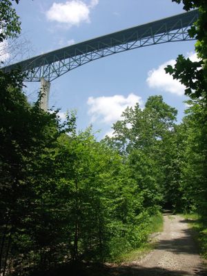
Phil G. McDonald Bridge, Interstate bridge in Raleigh County, West Virginia, United States.

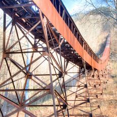
The Phil G. McDonald Bridge is a highway bridge in Raleigh County that carries four lanes of Interstate 64 across the state. It spans Glade Creek at a considerable height, supporting major transportation traffic through the region.

The structure was completed in 1988, marking the final stage of Interstate 64 construction through West Virginia. This achievement represented a major milestone in the state's transportation infrastructure development.

The bridge honors Phil G. McDonald, a West Virginia native recognized for his Medal of Honor during the Vietnam War. This naming reflects how the state commemorates figures from its communities who served with distinction.

The bridge provides essential passage for travelers moving north and south on Interstate 64 through the region. Its wide construction with multiple lanes allows steady traffic flow in both directions.

The bridge employs one of the tallest bridge pier structures in the nation, rising over 300 feet (91 meters) from foundation to truss underside. This engineering accomplishment makes it a remarkable example of construction techniques over challenging terrain.

The community of curious travelers

AroundUs brings together thousands of curated places, local tips, and hidden gems, enriched daily by 60,000 contributors worldwide.

Start exploring
Location
Inception
July 15, 1988
Official opening
July 15, 1988
GPS coordinates
37.76830,-81.04170
Latest update
December 9, 2025 18:46
Around this place
Babcock State Park
United States of America

Babcock State Park

25.9 km
Pipestem Resort State Park
United States of America

Pipestem Resort State Park

26.3 km
Bluestone Lake
United States of America

Bluestone Lake

19.8 km
Bluestone National Scenic River
United States of America

Bluestone National Scenic River

25.5 km
Bluestone State Park
United States of America

Bluestone State Park

19.1 km
Tamarack Marketplace
United States of America

Tamarack Marketplace

15.9 km
Little Beaver State Park
United States of America

Little Beaver State Park

3.7 km
Phillips-Sprague Mine
United States of America

Phillips-Sprague Mine

13.8 km
Camp Creek State Park
United States of America

Camp Creek State Park

30.5 km
Col. James Graham House
United States of America

Col. James Graham House

30.3 km
Bank of Glen Jean
United States of America

Bank of Glen Jean

20.4 km
Camp Washington-Carver Complex
United States of America

Camp Washington-Carver Complex

27.6 km
Summers County Courthouse
United States of America

Summers County Courthouse

17 km
Wildwood
United States of America

Wildwood

12.8 km
Hinton Historic District
United States of America

Hinton Historic District

17.3 km
Pence Springs Hotel Historic District
United States of America

Pence Springs Hotel Historic District

29.9 km
Beckley Courthouse Square Historic District
United States of America

Beckley Courthouse Square Historic District

12.9 km
Jordan's Chapel
United States of America

Jordan's Chapel

25.7 km
Mount Hope Historic District
United States of America

Mount Hope Historic District

17.7 km
Trump-Lilly Farmstead
United States of America

Trump-Lilly Farmstead

14.6 km
New River Company General Office Building
United States of America

New River Company General Office Building

17.9 km
Sophia Historic District
United States of America

Sophia Historic District

19.6 km
Dr. John Hughart House
United States of America

Dr. John Hughart House

24.6 km
Glade Creek Grist Mill
United States of America

Glade Creek Grist Mill

24.9 km
Sandstone Falls
United States of America

Sandstone Falls

12 km
Camp Brookside Environmental Education Center
United States of America

Camp Brookside Environmental Education Center

14.2 km
Nuttall Coal Mine Conveyor
United States of America

Nuttall Coal Mine Conveyor

31.5 km
Thurmond Historic District
United States of America

Thurmond Historic District

21.4 km
Show the full map
« Phil G. McDonald Bridge - Interstate bridge in Raleigh County, West Virginia, United States » is provided by Around Us (aroundus.com). Images and texts are derived from Wikimedia project under a Creative Commons license. You are allowed to copy, distribute, and modify copies of this page, under the conditions set by the license, as long as this note is clearly visible.

Discover hidden gems everywhere you go!

From secret cafés to breathtaking viewpoints, skip the crowded tourist spots and find places that match your style. Our app makes it easy with voice search, smart filtering, route optimization, and insider tips from travelers worldwide. Download now for the complete mobile experience.

Around Us App Screenshot

A unique approach to discovering new places

Le Figaro

All the places worth exploring

France Info

A tailor-made excursion in just a few clicks

20 Minutes

Around Us
Travel Guide & Maps
Download

Send to your phone

QR Code
1

Open the camera app on your mobile.

2

Point at the QR code with your camera. A notification will appear.

3

Tap the notification to open the link.