Enable Location

We need your location to show you interesting places around you

Discover nearby places

Find interesting locations and hidden gems around you

Precise directions

Get accurate directions and distances to places

Your location is never shared with other users. It's only used when you tap the location button.

Garfield Elementary School

Log in to your account

Start exploring — it's free

Trusted by 62,474 travelers worldwide

Continue with Google
Continue with Apple
or

We will send you a code to connect

By continuing, you accept our Terms and Conditions and our Privacy Policy

Check your inbox

We've sent a pincode in your inbox. Please enter the code below.

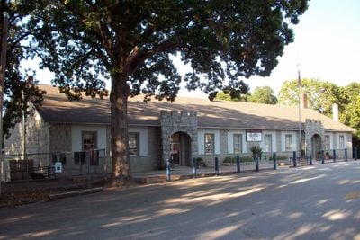
Garfield Elementary School, school building in Garfield, Arkansas

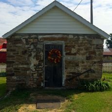
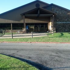
Garfield Elementary School is a stone schoolhouse in Garfield, Arkansas, featuring two protruding entrance areas on the front with arches above the openings and conveying a simple, sturdy appearance. The single-story building from 1941 extends in an east-to-west direction with multiple classrooms, offices, and a gathering room in the rear section.

The school was built in 1941 to replace an older institution that had served the area since 1885 and had fallen into poor condition. In 1996 it was officially listed on the National Register of Historic Places, gaining recognition for its history and architectural style.

The school carries the name of James A. Garfield, the twentieth president of the United States. The building reflects Rustic Revival architecture, a style common in public buildings of the early twentieth century that gives the schoolhouse a warm, sturdy appearance.

The building sits near the center of Garfield and is easily visible from the road, with ample space in a quiet setting surrounded by some trees. The stone features and arches are clearly visible and require no special equipment to explore the exterior.

The school served the community for more than 80 years before closing in 2024 due to financial and enrollment difficulties. A farewell celebration brought together former students, current pupils, and community members who shared memories and stories spanning this long period of service.

The community of curious travelers

AroundUs brings together thousands of curated places, local tips, and hidden gems, enriched daily by 60,000 contributors worldwide.

Start exploring
Location
Address
18432 Marshall Street
GPS coordinates
36.44860,-93.97140
Latest update
February 9, 2026 07:46
Around this place
Beaver Lake
United States of America

Beaver Lake

11.5 km
Blue Springs Heritage Center
United States of America

Blue Springs Heritage Center

14.3 km
Beaver Bridge
United States of America

Beaver Bridge

18.3 km
Hobbs State Park – Conservation Area
United States of America

Hobbs State Park – Conservation Area

18.4 km
Rogers Commercial Historic District
United States of America

Rogers Commercial Historic District

18.3 km
U.S. 62 White River Bridge
United States of America

U.S. 62 White River Bridge

13.3 km
Miller Homestead
United States of America

Miller Homestead

12 km
White River Bridge at Elkins
United States of America

White River Bridge at Elkins

18.4 km
Lane Hotel
United States of America

Lane Hotel

18.5 km
Rocky Branch School
United States of America

Rocky Branch School

13.9 km
Mulladay Hollow Bridge
United States of America

Mulladay Hollow Bridge

18.5 km
Blackburn House
United States of America

Blackburn House

18.3 km
Myler House
United States of America

Myler House

18.2 km
Raney House
United States of America

Raney House

18.8 km
Freeman-Felker House
United States of America

Freeman-Felker House

18.6 km
Bank of Rogers Building
United States of America

Bank of Rogers Building

18.3 km
Shady Grove School
United States of America

Shady Grove School

15.4 km
Coal Gap School
United States of America

Coal Gap School

10.2 km
Kefauver House
United States of America

Kefauver House

18.7 km
Parks-Reagan House
United States of America

Parks-Reagan House

18.7 km
Bryan House No. 2
United States of America

Bryan House No. 2

17.8 km
Campbell House
United States of America

Campbell House

18.9 km
Charles Juhre House
United States of America

Charles Juhre House

18.2 km
Mutual Aid Union Building
United States of America

Mutual Aid Union Building

18.5 km
Pea Ridge Commercial Historic District
United States of America

Pea Ridge Commercial Historic District

12.8 km
Daisy Airgun Museum
United States of America

Daisy Airgun Museum

18.4 km
Rogers Historical Museum
United States of America

Rogers Historical Museum

18.6 km
Pea Ridge National Military Park Visitor Center
United States of America

Pea Ridge National Military Park Visitor Center

4.9 km
Show the full map
« Garfield Elementary School - school building in Garfield, Arkansas » is provided by Around Us (aroundus.com). Images and texts are derived from Wikimedia project under a Creative Commons license. You are allowed to copy, distribute, and modify copies of this page, under the conditions set by the license, as long as this note is clearly visible.

Discover hidden gems everywhere you go!

From secret cafés to breathtaking viewpoints, skip the crowded tourist spots and find places that match your style. Our app makes it easy with voice search, smart filtering, route optimization, and insider tips from travelers worldwide. Download now for the complete mobile experience.

Around Us App Screenshot

A unique approach to discovering new places

Le Figaro

All the places worth exploring

France Info

A tailor-made excursion in just a few clicks

20 Minutes

Around Us
Travel Guide & Maps
Download

Send to your phone

QR Code
1

Open the camera app on your mobile.

2

Point at the QR code with your camera. A notification will appear.

3

Tap the notification to open the link.