Enable Location

We need your location to show you interesting places around you

Discover nearby places

Find interesting locations and hidden gems around you

Precise directions

Get accurate directions and distances to places

Your location is never shared with other users. It's only used when you tap the location button.

Log in to your account

Start exploring — it's free

Trusted by 63,020 travelers worldwide

Continue with Google
Continue with Apple
or

We will send you a code to connect

By continuing, you accept our Terms and Conditions and our Privacy Policy

Check your inbox

We've sent a pincode in your inbox. Please enter the code below.

Lamb Lake
Discussion Reviews Photo
1.7k Popularity

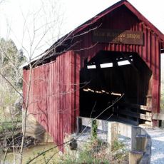
Lamb Lake, body of water

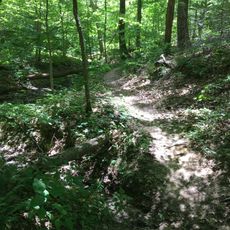
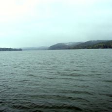
Lamb Lake is a reservoir covering about 270 acres in Johnson County, Indiana, completed in 1967. The body of water reaches a maximum depth of about 55 feet and features wooded shorelines with several small bays, creating a natural landscape along its edges.

The lake was constructed in 1967 as a water management project to control local water flow and provide recreation space. Over the decades it became a beloved spot managed by approximately 278 private property owners who share responsibility for its care and upkeep.

The lake is named after a local family and has become a gathering place for the surrounding community. Private residents manage the water together, creating a shared space where families and neighbors spend leisure time on weekends and throughout the year.

The lake is easily accessible by car with parking areas nearby; note that this is a private body of water restricted to residents and their guests. Spring through early fall offers the most pleasant weather for activities like fishing, boating, and picnicking along the shoreline.

The lake's spillway creates a waterfall roughly 55 feet high, making it one of Indiana's tallest waterfalls. This impressive cascade is visible from near the spillway and forms a striking natural feature where water drops in an arc toward the ravine below.

The community of curious travelers

AroundUs brings together thousands of curated places, local tips, and hidden gems, enriched daily by 60,000 contributors worldwide.

Start exploring
Location
GPS coordinates
39.35917,-86.18167
Latest update
February 9, 2026 08:19
Around this place
Camp Atterbury
United States of America

Camp Atterbury

14.4 km
Morgan–Monroe State Forest
United States of America

Morgan–Monroe State Forest

20.4 km
Weed Patch Hill
United States of America

Weed Patch Hill

21.6 km
Johnson County Museum of History
United States of America

Johnson County Museum of History

17.5 km
Honey Creek School
United States of America

Honey Creek School

21.1 km
Johnson County Courthouse Square
United States of America

Johnson County Courthouse Square

17.3 km
Cross School
United States of America

Cross School

17.5 km
East Washington Street Historic District
United States of America

East Washington Street Historic District

22 km
Brown County Courthouse Historic District
United States of America

Brown County Courthouse Historic District

17.8 km
Franklin Senior High School
United States of America

Franklin Senior High School

17.8 km
Morgantown Historic District
United States of America

Morgantown Historic District

7 km
Old Main
United States of America

Old Main

17.7 km
Franklin Commercial Historic District
United States of America

Franklin Commercial Historic District

17.3 km
Franklin College Library
United States of America

Franklin College Library

17.6 km
August Zeppenfeld House
United States of America

August Zeppenfeld House

17.1 km
Brown County Bridge No. 36
United States of America

Brown County Bridge No. 36

22.2 km
South Walnut Street Historic District
United States of America

South Walnut Street Historic District

18.6 km
Furnas Mill Bridge
United States of America

Furnas Mill Bridge

16 km
Toner Historic District
United States of America

Toner Historic District

19.1 km
Herriott House
United States of America

Herriott House

17.8 km
Van Nuys Farm
United States of America

Van Nuys Farm

16.5 km
Martin Place Historic District
United States of America

Martin Place Historic District

17.8 km
Neely House
United States of America

Neely House

21.8 km
Morgan County Fairgrounds
United States of America

Morgan County Fairgrounds

20.8 km
Bean Blossom Covered Bridge
United States of America

Bean Blossom Covered Bridge

12.6 km
Brown County Art Gallery
United States of America

Brown County Art Gallery

17.8 km
Lake Lemon
United States of America

Lake Lemon

21.7 km
Brown County Art Guild
United States of America

Brown County Art Guild

17.9 km
Show the full map
Reviews
Share your experience

No review yet

Discussions
Start a discussion...

No discussion yet

« Lamb Lake - body of water » is provided by Around Us (aroundus.com). Images and texts are derived from Wikimedia project under a Creative Commons license. You are allowed to copy, distribute, and modify copies of this page, under the conditions set by the license, as long as this note is clearly visible.

Discover hidden gems everywhere you go!

From secret cafés to breathtaking viewpoints, skip the crowded tourist spots and find places that match your style. Our app makes it easy with voice search, smart filtering, route optimization, and insider tips from travelers worldwide. Download now for the complete mobile experience.

Around Us App Screenshot

A unique approach to discovering new places

Le Figaro

All the places worth exploring

France Info

A tailor-made excursion in just a few clicks

20 Minutes

Around Us
Travel Guide & Maps
Download

Send to your phone

QR Code
1

Open the camera app on your mobile.

2

Point at the QR code with your camera. A notification will appear.

3

Tap the notification to open the link.