Enable Location

We need your location to show you interesting places around you

Discover nearby places

Find interesting locations and hidden gems around you

Precise directions

Get accurate directions and distances to places

Your location is never shared with other users. It's only used when you tap the location button.

Urban Route 66, Williams

Log in to your account

Start exploring — it's free

Trusted by 63,503 travelers worldwide

Continue with Google
Continue with Apple
or

We will send you a code to connect

By continuing, you accept our Terms and Conditions and our Privacy Policy

Check your inbox

We've sent a pincode in your inbox. Please enter the code below.

Discussion Reviews 1 Photos
2.5k Popularity

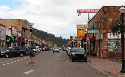
Urban Route 66, Williams, historic area in Arizona, US

Urban Route 66 in Williams is a street that forms part of the famous US Route 66 and runs through the center of town. It extends for about four blocks and is lined with buildings from the 1920s to 1940s that house shops, motels, and restaurants.

The street was paved in the 1920s as part of US Route 66 and brought travelers and business to Williams. Over the decades, gas stations, motels, and shops emerged along it, until Interstate 40 bypassed the route in 1984 and the street lost its role as a main travel corridor.

The street carries the name Route 66 and connects the past of automobile travel with today. Visitors can see how this street drew travelers across generations and how the community keeps its history alive in the shops and buildings that line it.

The street is easy to walk and offers a pleasant stroll through the downtown area of Williams. The best time to visit is during the day when shops are open and the details of the older buildings are clearly visible.

A gas station from the 1930s with its original canopy and old pumps still stands along the street. Similarly, the old theater from 1912 with its story of silent films, hidden activities, and the first talking picture shown in the area remains a notable sight.

The community of curious travelers

AroundUs brings together thousands of curated places, local tips, and hidden gems, enriched daily by 60,000 contributors worldwide.

Start exploring
Location
GPS coordinates
35.24889,-112.19194
Latest update
February 9, 2026 08:22
Around this place
Humphreys Peak
United States of America

Humphreys Peak

47.9 km
Lowell Observatory
United States of America

Lowell Observatory

48.2 km
Lava River Cave
United States of America

Lava River Cave

34 km
Red Rock-Secret Mountain Wilderness
United States of America

Red Rock-Secret Mountain Wilderness

43.9 km
Riordan Mansion State Historic Park
United States of America

Riordan Mansion State Historic Park

49 km
Museum of Northern Arizona
United States of America

Museum of Northern Arizona

47.9 km
Agassiz Peak
United States of America

Agassiz Peak

47.5 km
Kendrick Peak
United States of America

Kendrick Peak

35.7 km
Fremont Peak
United States of America

Fremont Peak

49 km
Sycamore Canyon Wilderness
United States of America

Sycamore Canyon Wilderness

34.5 km
The Arboretum at Flagstaff
United States of America

The Arboretum at Flagstaff

43.1 km
Barney Flat Historic Railroad Logging Landscape
United States of America

Barney Flat Historic Railroad Logging Landscape

11 km
Perkinsville Bridge
United States of America

Perkinsville Bridge

39.4 km
Camp Clover Ranger Station
United States of America

Camp Clover Ranger Station

2.8 km
First Methodist Episcopal Church and Parsonage
United States of America

First Methodist Episcopal Church and Parsonage

9 km
Riordan Mansion
United States of America

Riordan Mansion

48.9 km
Williams Residential Historic District
United States of America

Williams Residential Historic District

555 m
Route 66 Museum And Gift Shop
United States of America

Route 66 Museum And Gift Shop

340 m
Flagstaff Armory
United States of America

Flagstaff Armory

49.1 km
Pioneer Museum--Arizona Historical Society
United States of America

Pioneer Museum--Arizona Historical Society

48.9 km
Woody Mountain Lookout Tower
United States of America

Woody Mountain Lookout Tower

41.8 km
Volunteer Lookout Cabin
United States of America

Volunteer Lookout Cabin

27.2 km
Kendrick Mountain Fire Lookout Cabin
United States of America

Kendrick Mountain Fire Lookout Cabin

36 km
Bill Williams Lookout Tower
United States of America

Bill Williams Lookout Tower

5.6 km
Volunteer Lookout Tower
United States of America

Volunteer Lookout Tower

27.2 km
Little Hell Canyon Bridge
United States of America

Little Hell Canyon Bridge

27.1 km
Big Hell Canyon Railroad Bridge
United States of America

Big Hell Canyon Railroad Bridge

34.7 km
Little Hell Canyon Railroad Bridge
United States of America

Little Hell Canyon Railroad Bridge

27.1 km
Show the full map
Reviews
Share your experience

No review yet

Discussions
Start a discussion...

No discussion yet

« Urban Route 66, Williams - historic area in Arizona, US » is provided by Around Us (aroundus.com). Images and texts are derived from Wikimedia project under a Creative Commons license. You are allowed to copy, distribute, and modify copies of this page, under the conditions set by the license, as long as this note is clearly visible.

Discover hidden gems everywhere you go!

From secret cafés to breathtaking viewpoints, skip the crowded tourist spots and find places that match your style. Our app makes it easy with voice search, smart filtering, route optimization, and insider tips from travelers worldwide. Download now for the complete mobile experience.

Around Us App Screenshot

A unique approach to discovering new places

Le Figaro

All the places worth exploring

France Info

A tailor-made excursion in just a few clicks

20 Minutes

Around Us
Travel Guide & Maps
Download

Send to your phone

QR Code
1

Open the camera app on your mobile.

2

Point at the QR code with your camera. A notification will appear.

3

Tap the notification to open the link.