Humphreys Peak

Log in to your account

AroundUs is a community-driven map of interesting places, built by curious explorers like you. It grows with every review, story, and photo you share.
Connect to save your favorite spots, contribute locations, and create personalized routes.
Continue with Google
Continue with Apple
Continue with X
Continue with Facebook
Continue with email
By continuing, you accept our Terms and Conditions and our Privacy Policy
Create an account
Add to collection
Map
Suggest a change
Share

Humphreys Peak, Extinct volcano in Coconino County, Arizona

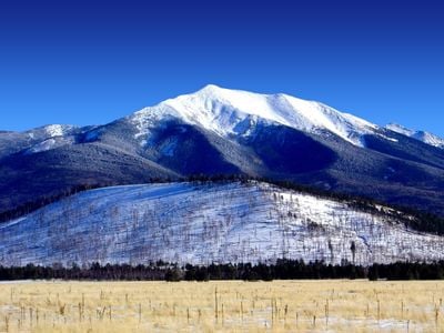
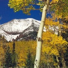
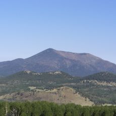
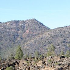
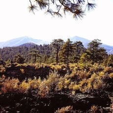
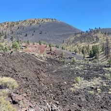
Humphreys Peak is an extinct volcano in Coconino County, Arizona, rising to 12633 feet (3851 meters) above sea level. The summit forms the highest point in the state and sits within the San Francisco Peaks, a volcanic mountain range north of Flagstaff.

The mountain received its name in 1870 in honor of General Andrew Humphreys, who served as a Union commander during the Civil War. Humphreys later became Chief of Engineers for the Army and directed numerous mapping expeditions across the American West.

The Diné call this mountain Dookʼoʼoosłííd, referring to a summit that holds snow throughout the year. This name reflects the spiritual importance the mountain carries for many Native American groups across the Southwest.

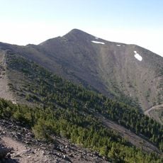
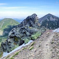
The Humphreys Trail starts at Arizona Snowbowl and runs 4.75 miles (7.6 kilometers) to the summit, with the full hike usually taking between 6 and 8 hours. Hikers should begin early in the day since afternoon thunderstorms are common during the summer months.

Temperatures on the summit stay below freezing for roughly six months each year, with only July averaging above 50 degrees Fahrenheit (10 degrees Celsius). Hikers can experience warm weather at the trailhead and icy conditions at the top on a single summer day.

Location: Arizona

Elevation above the sea: 3,851 m

GPS coordinates: 35.34638,-111.67796

Latest update: December 13, 2025 17:01

Photos
Around this place
San Francisco Peaks
United States of America

San Francisco Peaks

2.2 km
Lowell Observatory
United States of America

Lowell Observatory

16 km
Lava River Cave
United States of America

Lava River Cave

14.4 km
Riordan Mansion State Historic Park
United States of America

Riordan Mansion State Historic Park

17.6 km
Museum of Northern Arizona
United States of America

Museum of Northern Arizona

12.5 km
Agassiz Peak
United States of America

Agassiz Peak

2.3 km
Kachina Peaks Wilderness
United States of America

Kachina Peaks Wilderness

1.6 km
Kendrick Peak
United States of America

Kendrick Peak

17.1 km
Elden Pueblo
United States of America

Elden Pueblo

15.2 km
Fremont Peak
United States of America

Fremont Peak

3 km
Weatherford Hotel
United States of America

Weatherford Hotel

16.7 km
The Arboretum at Flagstaff
United States of America

The Arboretum at Flagstaff

21.3 km
Doyle Peak
United States of America

Doyle Peak

3.4 km
Railroad Addition Historic District
United States of America

Railroad Addition Historic District

16.8 km
O'Leary Peak
United States of America

O'Leary Peak

15.1 km
Lenox Crater
United States of America

Lenox Crater

13.5 km
Our Lady of Guadaloupe Church
United States of America

Our Lady of Guadaloupe Church

16.9 km
Presbyterian Church Parsonage
United States of America

Presbyterian Church Parsonage

16.6 km
Brannen-Devine House
United States of America

Brannen-Devine House

17.1 km
Lava Flow Trail
United States of America

Lava Flow Trail

14.6 km
Riordan Mansion
United States of America

Riordan Mansion

17.8 km
Flagstaff Armory
United States of America

Flagstaff Armory

16.9 km
Pioneer Museum--Arizona Historical Society
United States of America

Pioneer Museum--Arizona Historical Society

13.8 km
Flagstaff Southside Historic District
United States of America

Flagstaff Southside Historic District

17.1 km
Kendrick Mountain Fire Lookout Cabin
United States of America

Kendrick Mountain Fire Lookout Cabin

16.8 km
Flagstaff Federated Community Church
United States of America

Flagstaff Federated Community Church

16.4 km
O'Leary Peak Lookout Tower
United States of America

O'Leary Peak Lookout Tower

15.1 km
Northern Arizona Normal School Historic District
United States of America

Northern Arizona Normal School Historic District

17.2 km
Show the full map
Reviews

Visited this place? Tap the stars to rate it and share your experience / photos with the community! Try now! You can cancel it anytime.

« Humphreys Peak - Extinct volcano in Coconino County, Arizona » is provided by Around Us (aroundus.com). Images and texts are derived from Wikimedia project under a Creative Commons license. You are allowed to copy, distribute, and modify copies of this page, under the conditions set by the license, as long as this note is clearly visible.

Discover hidden gems everywhere you go!

From secret cafés to breathtaking viewpoints, skip the crowded tourist spots and find places that match your style. Our app makes it easy with voice search, smart filtering, route optimization, and insider tips from travelers worldwide. Download now for the complete mobile experience.

Around Us App Screenshot

A unique approach to discovering new places

Le Figaro

All the places worth exploring

France Info

A tailor-made excursion in just a few clicks

20 Minutes