Enable Location

We need your location to show you interesting places around you

Discover nearby places

Find interesting locations and hidden gems around you

Precise directions

Get accurate directions and distances to places

Your location is never shared with other users. It's only used when you tap the location button.

Kachina Peaks Wilderness

Log in to your account

Start exploring — it's free

Trusted by 62,915 travelers worldwide

Continue with Google
Continue with Apple
or

We will send you a code to connect

By continuing, you accept our Terms and Conditions and our Privacy Policy

Check your inbox

We've sent a pincode in your inbox. Please enter the code below.

Kachina Peaks Wilderness
Discussion Reviews 1 Photos
4.7k Popularity

Kachina Peaks Wilderness, Mountain wilderness in Coconino County, United States.

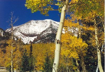
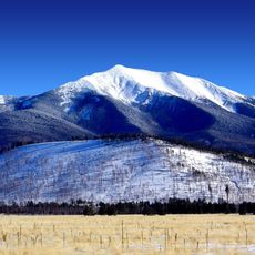
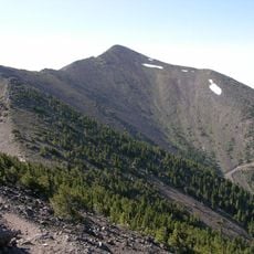
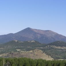
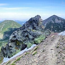
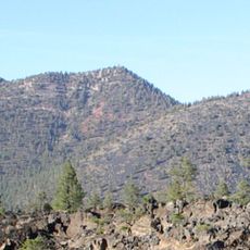
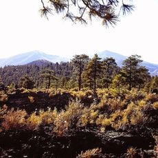
Kachina Peaks Wilderness is a mountain area in Coconino County containing several summits, including Humphreys Peak at about 13,000 feet, located within Coconino National Forest. The terrain features glacial moraines, old stream beds, and diverse elevations ranging from forested slopes to alpine zones.

This area formed from a composite volcano that erupted about two million years ago, leaving behind the terrain visible today. The volcanic activity shaped the current landscape with its moraines and geological features.

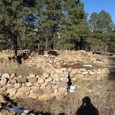
Several Native American tribes, including the Havasupai, Hopi, Navajo, and Zuni, maintain religious shrines and sacred sites throughout this wilderness, viewing the peaks as spiritually significant places for their traditions. The mountains hold an important role in their ceremonies and spiritual practices.

Visitors need Forest Service permits for backcountry travel, with group sizes limited to 12 people to protect the area. Camping is prohibited above the tree line and in Inner Basin, which affects planning for multi-day trips.

The area preserves a zone of arctic-alpine vegetation covering about 2 square miles, including San Francisco Peaks groundsel that grows only here. This plant is found unexpectedly at this southern elevation, revealing the site's distinctive growing conditions.

The community of curious travelers

AroundUs brings together thousands of curated places, local tips, and hidden gems, enriched daily by 60,000 contributors worldwide.

Start exploring
Location
GPS coordinates
35.33940,-111.66200
Latest update
December 10, 2025 20:05
Around this place
Humphreys Peak
United States of America

Humphreys Peak

1.6 km
San Francisco Peaks
United States of America

San Francisco Peaks

770 m
Lowell Observatory
United States of America

Lowell Observatory

15.2 km
Lava River Cave
United States of America

Lava River Cave

15.8 km
Riordan Mansion State Historic Park
United States of America

Riordan Mansion State Historic Park

16.8 km
Museum of Northern Arizona
United States of America

Museum of Northern Arizona

11.7 km
Agassiz Peak
United States of America

Agassiz Peak

2.1 km
Kendrick Peak
United States of America

Kendrick Peak

18.8 km
Elden Pueblo
United States of America

Elden Pueblo

13.7 km
Fremont Peak
United States of America

Fremont Peak

1.8 km
Orpheum Theater
United States of America

Orpheum Theater

15.7 km
The Arboretum at Flagstaff
United States of America

The Arboretum at Flagstaff

20.9 km
Doyle Peak
United States of America

Doyle Peak

1.8 km
Railroad Addition Historic District
United States of America

Railroad Addition Historic District

15.8 km
O'Leary Peak
United States of America

O'Leary Peak

14.1 km
Lenox Crater
United States of America

Lenox Crater

12.2 km
Our Lady of Guadaloupe Church
United States of America

Our Lady of Guadaloupe Church

16 km
Presbyterian Church Parsonage
United States of America

Presbyterian Church Parsonage

15.6 km
Brannen-Devine House
United States of America

Brannen-Devine House

16.2 km
Riordan Mansion
United States of America

Riordan Mansion

16.9 km
Flagstaff Armory
United States of America

Flagstaff Armory

16 km
Pioneer Museum--Arizona Historical Society
United States of America

Pioneer Museum--Arizona Historical Society

12.9 km
Flagstaff Southside Historic District
United States of America

Flagstaff Southside Historic District

16.2 km
Kendrick Mountain Fire Lookout Cabin
United States of America

Kendrick Mountain Fire Lookout Cabin

18.4 km
Flagstaff Federated Community Church
United States of America

Flagstaff Federated Community Church

15.5 km
O'Leary Peak Lookout Tower
United States of America

O'Leary Peak Lookout Tower

14.1 km
Flagstaff City-coconino County Public Library
United States of America

Flagstaff City-coconino County Public Library

15.6 km
Northern Arizona Normal School Historic District
United States of America

Northern Arizona Normal School Historic District

16.3 km
Show the full map
Reviews
Share your experience

No review yet

Discussions
Start a discussion...

No discussion yet

« Kachina Peaks Wilderness - Mountain wilderness in Coconino County, United States » is provided by Around Us (aroundus.com). Images and texts are derived from Wikimedia project under a Creative Commons license. You are allowed to copy, distribute, and modify copies of this page, under the conditions set by the license, as long as this note is clearly visible.

Discover hidden gems everywhere you go!

From secret cafés to breathtaking viewpoints, skip the crowded tourist spots and find places that match your style. Our app makes it easy with voice search, smart filtering, route optimization, and insider tips from travelers worldwide. Download now for the complete mobile experience.

Around Us App Screenshot

A unique approach to discovering new places

Le Figaro

All the places worth exploring

France Info

A tailor-made excursion in just a few clicks

20 Minutes

Around Us
Travel Guide & Maps
Download

Send to your phone

QR Code
1

Open the camera app on your mobile.

2

Point at the QR code with your camera. A notification will appear.

3

Tap the notification to open the link.