Enable Location

We need your location to show you interesting places around you

Discover nearby places

Find interesting locations and hidden gems around you

Precise directions

Get accurate directions and distances to places

Your location is never shared with other users. It's only used when you tap the location button.

Agassiz Peak

Log in to your account

Start exploring — it's free

Trusted by 62,914 travelers worldwide

Continue with Google
Continue with Apple
or

We will send you a code to connect

By continuing, you accept our Terms and Conditions and our Privacy Policy

Check your inbox

We've sent a pincode in your inbox. Please enter the code below.

Agassiz Peak
Discussion Reviews 1 Photos
5.8k Popularity

Agassiz Peak, Mountain summit in Coconino County, Arizona, US

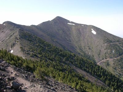
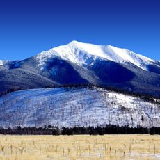
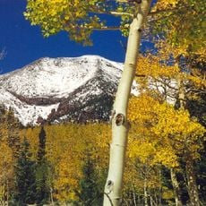
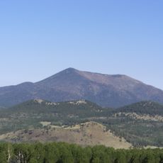
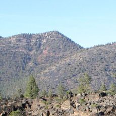
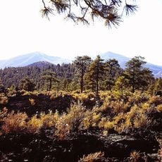
Agassiz Peak rises to approximately 12,356 feet within the San Francisco Peaks range and is the second-highest mountain in Arizona. The summit is located in Coconino County and forms part of a connected mountain range that dominates the surrounding landscape.

The peak was named after Louis Agassiz, a 19th-century Swiss scientist who made major contributions to glacier research. His name became attached to this summit as a tribute to his influence on geological understanding of mountain landscapes.

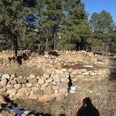
The San Francisco Peaks, which include this summit, hold sacred meaning for several Native American tribes of the Southwest. You can sense the deep spiritual connection that these mountains represent for indigenous peoples.

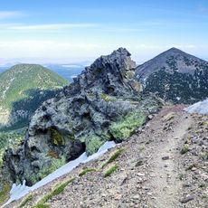
Access to the summit is usually restricted to protect a rare plant species found at this elevation, with entry permitted mainly during winter months when snow covers the ground. Visitors should check current access regulations before planning a trip, as conditions vary by season.

The summit marks the southernmost point in the continuous United States that exceeds 12,000 feet in elevation. This geographic distinction makes it notable for climbers and nature enthusiasts tracking high-altitude records.

The community of curious travelers

AroundUs brings together thousands of curated places, local tips, and hidden gems, enriched daily by 60,000 contributors worldwide.

Start exploring
Location
Elevation above the sea
3,766 m
GPS coordinates
35.32594,-111.67775
Latest update
December 10, 2025 16:22
Around this place
Humphreys Peak
United States of America

Humphreys Peak

2.3 km
San Francisco Peaks
United States of America

San Francisco Peaks

2.8 km
Lowell Observatory
United States of America

Lowell Observatory

13.8 km
Lava River Cave
United States of America

Lava River Cave

14.5 km
Riordan Mansion State Historic Park
United States of America

Riordan Mansion State Historic Park

15.4 km
Museum of Northern Arizona
United States of America

Museum of Northern Arizona

10.2 km
Kachina Peaks Wilderness
United States of America

Kachina Peaks Wilderness

2.1 km
Kendrick Peak
United States of America

Kendrick Peak

18.2 km
Elden Pueblo
United States of America

Elden Pueblo

13.6 km
Fremont Peak
United States of America

Fremont Peak

1.6 km
Orpheum Theater
United States of America

Orpheum Theater

14.4 km
The Arboretum at Flagstaff
United States of America

The Arboretum at Flagstaff

19.1 km
Doyle Peak
United States of America

Doyle Peak

2.9 km
Railroad Addition Historic District
United States of America

Railroad Addition Historic District

14.5 km
O'Leary Peak
United States of America

O'Leary Peak

16.1 km
Lenox Crater
United States of America

Lenox Crater

14 km
Our Lady of Guadaloupe Church
United States of America

Our Lady of Guadaloupe Church

14.7 km
Presbyterian Church Parsonage
United States of America

Presbyterian Church Parsonage

14.3 km
Brannen-Devine House
United States of America

Brannen-Devine House

14.9 km
Riordan Mansion
United States of America

Riordan Mansion

15.5 km
Flagstaff Armory
United States of America

Flagstaff Armory

14.7 km
Pioneer Museum--Arizona Historical Society
United States of America

Pioneer Museum--Arizona Historical Society

11.6 km
Flagstaff Southside Historic District
United States of America

Flagstaff Southside Historic District

14.9 km
Kendrick Mountain Fire Lookout Cabin
United States of America

Kendrick Mountain Fire Lookout Cabin

17.8 km
Flagstaff Federated Community Church
United States of America

Flagstaff Federated Community Church

14.2 km
O'Leary Peak Lookout Tower
United States of America

O'Leary Peak Lookout Tower

16.1 km
Northern Arizona Normal School Historic District
United States of America

Northern Arizona Normal School Historic District

14.9 km
Flagstaff City-coconino County Public Library
United States of America

Flagstaff City-coconino County Public Library

14.3 km
Show the full map
Reviews
Share your experience

No review yet

Discussions
Start a discussion...

No discussion yet

« Agassiz Peak - Mountain summit in Coconino County, Arizona, US » is provided by Around Us (aroundus.com). Images and texts are derived from Wikimedia project under a Creative Commons license. You are allowed to copy, distribute, and modify copies of this page, under the conditions set by the license, as long as this note is clearly visible.

Discover hidden gems everywhere you go!

From secret cafés to breathtaking viewpoints, skip the crowded tourist spots and find places that match your style. Our app makes it easy with voice search, smart filtering, route optimization, and insider tips from travelers worldwide. Download now for the complete mobile experience.

Around Us App Screenshot

A unique approach to discovering new places

Le Figaro

All the places worth exploring

France Info

A tailor-made excursion in just a few clicks

20 Minutes

Around Us
Travel Guide & Maps
Download

Send to your phone

QR Code
1

Open the camera app on your mobile.

2

Point at the QR code with your camera. A notification will appear.

3

Tap the notification to open the link.