Hall Covered Bridge

Log in to your account

AroundUs is a community-driven map of interesting places, built by curious explorers like you. It grows with every review, story, and photo you share.
Connect to save your favorite spots, contribute locations, and create personalized routes.
By continuing, you accept our Terms and Conditions and our Privacy Policy
Add to collection
Map
Suggest a change
Share

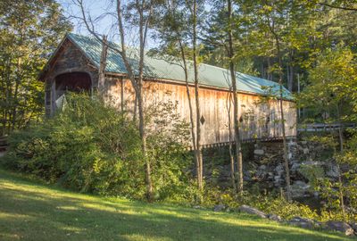
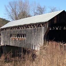
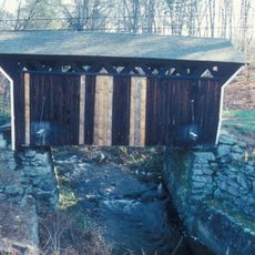
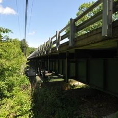
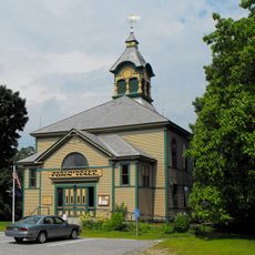
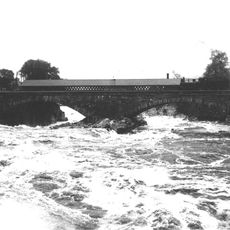
Hall Covered Bridge, Covered bridge in Rockingham, US

Hall Covered Bridge is a wooden bridge with a protective roof in Rockingham, Vermont that crosses a waterway and represents a typical example of American bridge-building tradition. The construction displays the craftsmanship of 19th-century carpenters and engineers who built these structures using wooden trusses fitted together with precision.

The bridge was built in the 19th century using American construction methods that relied on wood and sturdy trusses to span waterways. Its listing on the National Register of Historic Places recognizes its importance as a record of early transportation infrastructure.

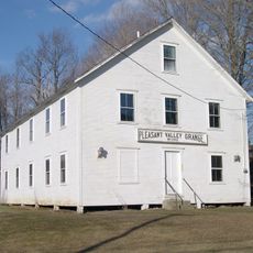
The bridge stands as a symbol of local identity, showing how the community values its connection to craftsmanship and early engineering skills. Visitors can see the handiwork of those builders reflected in how the wooden structure was assembled.

Access to the bridge is available through marked parking areas and walking paths that remain passable in different weather conditions. Visitors should expect a level ground surface and can find information about its history and construction nearby.

The roof protects not just from rain but also slows wood decay significantly, allowing these bridges to last much longer than open structures. This simple but effective concept made covered bridges the preferred building style across New England.

Location: Rockingham

Address: Hall Bridge Road

GPS coordinates: 43.13667,-72.48778

Latest update: December 14, 2025 18:01

Photos
Around this place
Steamtown, U.S.A.
United States of America

Steamtown, U.S.A.

3.1 km
United States of America

Westminster massacre

7.4 km
Arch Bridge
United States of America

Arch Bridge

3.2 km
Vilas Bridge
United States of America

Vilas Bridge

3.9 km
Rockingham Meeting House
United States of America

Rockingham Meeting House

5.7 km
United States of America

Great Falls

3.9 km
Worrall Covered Bridge
United States of America

Worrall Covered Bridge

9.2 km
Drewsville Mansion
United States of America

Drewsville Mansion

7.8 km
Bellows Falls Times Building
United States of America

Bellows Falls Times Building

3.7 km
Bellows Falls Neighborhood Historic District
United States of America

Bellows Falls Neighborhood Historic District

3.2 km
Walpole Academy
United States of America

Walpole Academy

8.2 km
Gas Station at Bridge and Island Streets
United States of America

Gas Station at Bridge and Island Streets

3.7 km
Stephen Rowe Bradley House
United States of America

Stephen Rowe Bradley House

7.9 km
Adams Gristmill Warehouse
United States of America

Adams Gristmill Warehouse

2.7 km
Prentiss Bridge
United States of America

Prentiss Bridge

7.8 km
Old Brick Church
United States of America

Old Brick Church

7.5 km
Peck-Porter House
United States of America

Peck-Porter House

8.2 km
Rockingham Village Historic District
United States of America

Rockingham Village Historic District

5.7 km
William A. Hall House
United States of America

William A. Hall House

3.5 km
Westminster Terrace Historic District
United States of America

Westminster Terrace Historic District

3.8 km
Williams River Route 5 Bridge
United States of America

Williams River Route 5 Bridge

5.6 km
Williams Street Extension Historic District
United States of America

Williams Street Extension Historic District

2.9 km
George-Pine-Henry Street Historic District
United States of America

George-Pine-Henry Street Historic District

3.1 km
Rockingham Free Public Library
United States of America

Rockingham Free Public Library

3.6 km
Westminster Village Historic District
United States of America

Westminster Village Historic District

8 km
Tucker Toll Covered Bridge
United States of America

Tucker Toll Covered Bridge

3.9 km
Cheshire Railroad Connecticut River Covered Bridge
United States of America

Cheshire Railroad Connecticut River Covered Bridge

3.9 km
GMRC Bellows Falls Stone Arch Bridge
United States of America

GMRC Bellows Falls Stone Arch Bridge

3.9 km
Show the full map
Reviews

Visited this place? Tap the stars to rate it and share your experience / photos with the community! Try now! You can cancel it anytime.

« Hall Covered Bridge - Covered bridge in Rockingham, US » is provided by Around Us (aroundus.com). Images and texts are derived from Wikimedia project under a Creative Commons license. You are allowed to copy, distribute, and modify copies of this page, under the conditions set by the license, as long as this note is clearly visible.

Discover hidden gems everywhere you go!

From secret cafés to breathtaking viewpoints, skip the crowded tourist spots and find places that match your style. Our app makes it easy with voice search, smart filtering, route optimization, and insider tips from travelers worldwide. Download now for the complete mobile experience.

Around Us App Screenshot

A unique approach to discovering new places

Le Figaro

All the places worth exploring

France Info

A tailor-made excursion in just a few clicks

20 Minutes