Enable Location

We need your location to show you interesting places around you

Discover nearby places

Find interesting locations and hidden gems around you

Precise directions

Get accurate directions and distances to places

Your location is never shared with other users. It's only used when you tap the location button.

Arch Bridge

Log in to your account

Start exploring — it's free

Trusted by 61,908 travelers worldwide

Continue with Google
Continue with Apple
or

We will send you a code to connect

By continuing, you accept our Terms and Conditions and our Privacy Policy

Check your inbox

We've sent a pincode in your inbox. Please enter the code below.

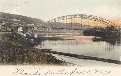
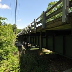
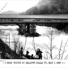
Arch Bridge, Road bridge in Bellows Falls, US.

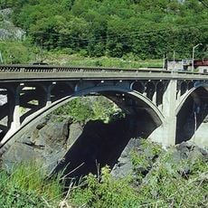
Arch Bridge is a road bridge with a single arch that spans the Connecticut River between North Walpole and Bellows Falls. The steel structure connects both banks of the waterway with a flowing curve.

The structure was completed in 1905 and was at that time the longest three-hinged arch bridge in the United States. It represented an important milestone in bridge engineering.

The bridge connects New Hampshire and Vermont and serves as an important link between two New England communities. People use it daily to cross between the two states for work, shopping, and visiting.

The structure carries vehicle traffic on New Hampshire Route 12 and Vermont Route 121 and is easily accessible by car. Pedestrians can also walk across.

The three-hinged design allows the bridge to flex with temperature changes and ground movement without building up internal stress. This engineering feature has helped it last over a century.

The community of curious travelers

AroundUs brings together thousands of curated places, local tips, and hidden gems, enriched daily by 60,000 contributors worldwide.

Start exploring
Location
Location
GPS coordinates
43.13790,-72.44850
Latest update
December 11, 2025 18:11
Around this place
Steamtown, U.S.A.
United States of America

Steamtown, U.S.A.

526 m
United States of America

Westminster massacre

7.4 km
Vilas Bridge
United States of America

Vilas Bridge

732 m
Rockingham Meeting House
United States of America

Rockingham Meeting House

6.4 km
United States of America

Great Falls

749 m
Drewsville Mansion
United States of America

Drewsville Mansion

4.7 km
Hall Covered Bridge
United States of America

Hall Covered Bridge

3.2 km
Bellows Falls Times Building
United States of America

Bellows Falls Times Building

599 m
Cold River Bridge
United States of America

Cold River Bridge

9.1 km
Bellows Falls Neighborhood Historic District
United States of America

Bellows Falls Neighborhood Historic District

727 m
Walpole Academy
United States of America

Walpole Academy

6.8 km
Gas Station at Bridge and Island Streets
United States of America

Gas Station at Bridge and Island Streets

605 m
Stephen Rowe Bradley House
United States of America

Stephen Rowe Bradley House

6.7 km
Adams Gristmill Warehouse
United States of America

Adams Gristmill Warehouse

848 m
Prentiss Bridge
United States of America

Prentiss Bridge

4.7 km
Shedd-Porter Memorial Library
United States of America

Shedd-Porter Memorial Library

7.2 km
Peck-Porter House
United States of America

Peck-Porter House

6.9 km
Rockingham Village Historic District
United States of America

Rockingham Village Historic District

6.5 km
William A. Hall House
United States of America

William A. Hall House

911 m
Westminster Terrace Historic District
United States of America

Westminster Terrace Historic District

1.3 km
Williams River Route 5 Bridge
United States of America

Williams River Route 5 Bridge

5.1 km
Williams Street Extension Historic District
United States of America

Williams Street Extension Historic District

417 m
George-Pine-Henry Street Historic District
United States of America

George-Pine-Henry Street Historic District

774 m
Rockingham Free Public Library
United States of America

Rockingham Free Public Library

851 m
Westminster Village Historic District
United States of America

Westminster Village Historic District

7.9 km
Tucker Toll Covered Bridge
United States of America

Tucker Toll Covered Bridge

732 m
Cheshire Railroad Connecticut River Covered Bridge
United States of America

Cheshire Railroad Connecticut River Covered Bridge

720 m
GMRC Bellows Falls Stone Arch Bridge
United States of America

GMRC Bellows Falls Stone Arch Bridge

720 m
Show the full map
« Arch Bridge - Road bridge in Bellows Falls, US » is provided by Around Us (aroundus.com). Images and texts are derived from Wikimedia project under a Creative Commons license. You are allowed to copy, distribute, and modify copies of this page, under the conditions set by the license, as long as this note is clearly visible.

Discover hidden gems everywhere you go!

From secret cafés to breathtaking viewpoints, skip the crowded tourist spots and find places that match your style. Our app makes it easy with voice search, smart filtering, route optimization, and insider tips from travelers worldwide. Download now for the complete mobile experience.

Around Us App Screenshot

A unique approach to discovering new places

Le Figaro

All the places worth exploring

France Info

A tailor-made excursion in just a few clicks

20 Minutes

Around Us
Travel Guide & Maps
Download

Send to your phone

QR Code
1

Open the camera app on your mobile.

2

Point at the QR code with your camera. A notification will appear.

3

Tap the notification to open the link.