Chest opened
+${chestReward.xp} XP
Explorer
NOUVEAU ×${chestReward.collectible.quantity}
tapez pour fermer
Chest locked

Open chests in the app

Around Us is built for your phone — chests unlock when you walk, explore and capture nearby places.

Enable Location

We need your location to show you interesting places around you

Discover nearby places

Find interesting locations and hidden gems around you

Precise directions

Get accurate directions and distances to places

Your location is never shared with other users. It's only used when you tap the location button.

Massawepie Mire

Log in to your account

Start exploring — it's free

Trusted by 72,885 travelers worldwide

Continue with Google
Continue with Apple
or

We will send you a code to connect

By continuing, you accept our Terms and Conditions and our Privacy Policy

Check your inbox

We've sent a pincode in your inbox. Please enter the code below.

Massawepie Mire
Discussion Reviews 1 Photos
1.4k Popularity

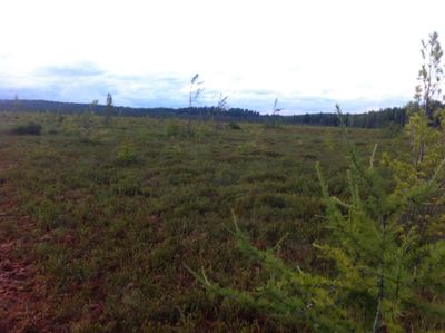
Massawepie Mire, Large bog in St. Lawrence County, United States.

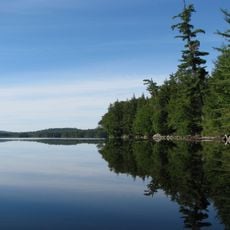
Massawepie Mire is a large bog in St. Lawrence County featuring sphagnum moss, black spruce trees, and specialized carnivorous plants across its wetland terrain. The mire forms a natural landscape with the vegetation patterns typical of this ecosystem type.

Old railroad beds from industrial times run through the surrounding land, marking past economic uses of the region. These remnants show how the landscape was shaped by earlier development and resource extraction.

Scout camps maintain the grounds through educational programs focused on nature preservation and outdoor skill development for young people. These facilities have shaped how the land is used and cared for over many generations.

Access is available via Massawepie Road, but entry is restricted between June 15 and August 31 due to scout camp use. Those visiting outside these dates should prepare for uneven, wet terrain and bring appropriate footwear.

The bog harbors rare bird populations like spruce grouse, Canada jay, and two-barred crossbill in their natural habitat. These birds thrive here because the mire conditions suit their specific ways of living.

The community of curious travelers

AroundUs brings together thousands of curated places, local tips, and hidden gems, enriched daily by 60,000 contributors worldwide.

Start exploring
GPS coordinates
44.24370,-74.65430
Latest update
December 14, 2025 16:42
Around this place
Adirondack Park
United States of America

Adirondack Park

37.3 km
Camp Topridge
United States of America

Camp Topridge

34.3 km
Ampersand Mountain
United States of America

Ampersand Mountain

36 km
Five Ponds Wilderness Area
United States of America

Five Ponds Wilderness Area

31.4 km
Saint Regis Canoe Area
United States of America

Saint Regis Canoe Area

32.2 km
Knollwood Club
United States of America

Knollwood Club

38.2 km
Wild Center
United States of America

Wild Center

17.4 km
Azure Mountain
United States of America

Azure Mountain

35.3 km
Seward Mountain
United States of America

Seward Mountain

37.5 km
United States of America

Saint Regis Mountain

31.7 km
Camp Wild Air
United States of America

Camp Wild Air

35.3 km
High Falls on the Oswegatchie River
United States of America

High Falls on the Oswegatchie River

28.2 km
Mount Emmons
United States of America

Mount Emmons

36.9 km
Beth Joseph Synagogue
United States of America

Beth Joseph Synagogue

15.3 km
Donaldson Mountain
United States of America

Donaldson Mountain

36.7 km
St. John's in the Wilderness Episcopal Church
United States of America

St. John's in the Wilderness Episcopal Church

39.1 km
Azure Mountain Fire Observation Station
United States of America

Azure Mountain Fire Observation Station

35.3 km
Arab Mountain Fire Observation Station
United States of America

Arab Mountain Fire Observation Station

6.8 km
Wanakena Footbridge
United States of America

Wanakena Footbridge

24.6 km
George and John R. Hunt Memorial Building
United States of America

George and John R. Hunt Memorial Building

27.4 km
Camp Eagle Island
United States of America

Camp Eagle Island

25.9 km
St. Regis Mountain Fire Observation Station
United States of America

St. Regis Mountain Fire Observation Station

31.7 km
Little Red
United States of America

Little Red

40.4 km
Round Lake Wilderness Area
United States of America

Round Lake Wilderness Area

20 km
Wanakena Presbyterian Church
United States of America

Wanakena Presbyterian Church

24.5 km
Brighton Town Hall
United States of America

Brighton Town Hall

40.1 km
Ryan Cottage
United States of America

Ryan Cottage

40.8 km
Lady Tree Lodge
United States of America

Lady Tree Lodge

29.3 km
Show the full map
Reviews
Share your experience

No review yet

Discussions
Start a discussion...

No discussion yet

« Massawepie Mire - Large bog in St. Lawrence County, United States » is provided by Around Us (aroundus.com). Images and texts are derived from Wikimedia project under a Creative Commons license. You are allowed to copy, distribute, and modify copies of this page, under the conditions set by the license, as long as this note is clearly visible.

Discover hidden gems everywhere you go!

From secret cafés to breathtaking viewpoints, skip the crowded tourist spots and find places that match your style. Our app makes it easy with voice search, smart filtering, route optimization, and insider tips from travelers worldwide. Download now for the complete mobile experience.

Around Us App Screenshot

A unique approach to discovering new places

Le Figaro

All the places worth exploring

France Info

A tailor-made excursion in just a few clicks

20 Minutes

Around Us
Travel Guide & Maps
Download

Send to your phone

QR Code
1

Open the camera app on your mobile.

2

Point at the QR code with your camera. A notification will appear.

3

Tap the notification to open the link.