Scatter Creek Unit

Log in to your account

AroundUs is a community-driven map of interesting places, built by curious explorers like you. It grows with every review, story, and photo you share.
Connect to save your favorite spots, contribute locations, and create personalized routes.
Continue with Google
Continue with Apple
Continue with X
Continue with Facebook
Continue with email
By continuing, you accept our Terms and Conditions and our Privacy Policy
Create an account
Add to collection
Map
Suggest a change
Share

Scatter Creek Unit, Protected prairie area in Thurston County, Washington, US

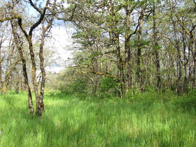
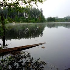
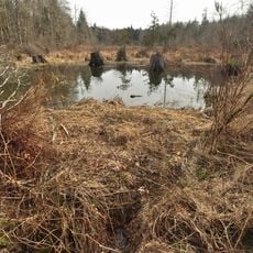
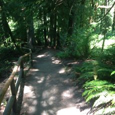
Scatter Creek Unit covers 960 acres of prairie wetlands and forests split into North and South sections, each with its own parking area and trail network. The landscape includes open grasslands mixed with wooded areas and water features that visitors can explore on foot.

The land was settled by George and Marita Miller in the 1850s and later belonged to Reece Brewer until a wildfire destroyed the original buildings. The property was eventually protected to preserve this distinctive natural landscape for future generations.

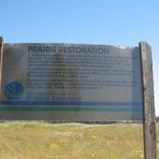
The site preserves native prairie grasslands found throughout Washington, supporting numerous plants and animals through active land management and seasonal burns.

Each section has its own parking area, and visitors should stay on marked trails while respecting private property boundaries around the site. Wearing sturdy footwear is recommended since paths cross through wet meadows and wooded terrain.

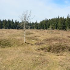
The site features Mima mounds in both North and South sections, rare geological formations that support stands of Garry oak and Oregon ash trees. These unusual hills remain a puzzle to scientists, with their exact origin still debated among researchers.

GPS coordinates: 46.83300,-123.00700

Latest update: December 14, 2025 17:41

Photos
Around this place
Washington State Capitol
United States of America

Washington State Capitol

23.9 km
Mima Mounds
United States of America

Mima Mounds

8 km
Washington Governor's Mansion
United States of America

Washington Governor's Mansion

23.8 km
Millersylvania State Park
United States of America

Millersylvania State Park

11.2 km
Capitol State Forest
United States of America

Capitol State Forest

17.6 km
Mima Mounds Natural Area Preserve
United States of America

Mima Mounds Natural Area Preserve

7.9 km
Tumwater Falls
United States of America

Tumwater Falls

21.7 km
Olympic Flight Museum
United States of America

Olympic Flight Museum

17.9 km
Claquato Church
United States of America

Claquato Church

21.2 km
Watershed Park
United States of America

Watershed Park

23.6 km
Monarch Contemporary Art Center and Sculpture Park
United States of America

Monarch Contemporary Art Center and Sculpture Park

20.8 km
Capitol Peak
United States of America

Capitol Peak

18.5 km
Miller–Brewer House
United States of America

Miller–Brewer House

566 m
Joel M. Pritchard Building
United States of America

Joel M. Pritchard Building

23.7 km
Insurance Building
United States of America

Insurance Building

23.9 km
Cloverfields
United States of America

Cloverfields

22.9 km
Crosby House
United States of America

Crosby House

22.3 km
St. John's Episcopal Church
United States of America

St. John's Episcopal Church

23.5 km
Tenino Stone Company Quarry
United States of America

Tenino Stone Company Quarry

12 km
Tenino Downtown Historic District
United States of America

Tenino Downtown Historic District

12.1 km
Du Pen Fountain
United States of America

Du Pen Fountain

23.7 km
Tumwater Methodist Church
United States of America

Tumwater Methodist Church

21.6 km
Vietnam Veterans Memorial
Vietnam

Vietnam Veterans Memorial

23.9 km
Bear Track Landing Waterpark
United States of America

Bear Track Landing Waterpark

4.8 km
Liberty Theater
United States of America

Liberty Theater

13.3 km
Chehalis Theatre
United States of America

Chehalis Theatre

18.8 km
St. Helens Theatre
United States of America

St. Helens Theatre

18.9 km
Tumwater Historic District
United States of America

Tumwater Historic District

22.1 km
Show the full map
Reviews

Visited this place? Tap the stars to rate it and share your experience / photos with the community! Try now! You can cancel it anytime.

« Scatter Creek Unit - Protected prairie area in Thurston County, Washington, US » is provided by Around Us (aroundus.com). Images and texts are derived from Wikimedia project under a Creative Commons license. You are allowed to copy, distribute, and modify copies of this page, under the conditions set by the license, as long as this note is clearly visible.

Discover hidden gems everywhere you go!

From secret cafés to breathtaking viewpoints, skip the crowded tourist spots and find places that match your style. Our app makes it easy with voice search, smart filtering, route optimization, and insider tips from travelers worldwide. Download now for the complete mobile experience.

Around Us App Screenshot

A unique approach to discovering new places

Le Figaro

All the places worth exploring

France Info

A tailor-made excursion in just a few clicks

20 Minutes