Enable Location

We need your location to show you interesting places around you

Discover nearby places

Find interesting locations and hidden gems around you

Precise directions

Get accurate directions and distances to places

Your location is never shared with other users. It's only used when you tap the location button.

Log in to your account

Start exploring — it's free

Trusted by 62,949 travelers worldwide

Continue with Google
Continue with Apple
or

We will send you a code to connect

By continuing, you accept our Terms and Conditions and our Privacy Policy

Check your inbox

We've sent a pincode in your inbox. Please enter the code below.

Yankee Doodle Bridge
Discussion Reviews Photo
1.4k Popularity

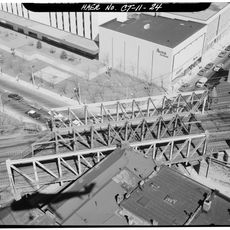
Yankee Doodle Bridge, Highway bridge in Norwalk, United States.

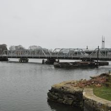
Yankee Doodle Bridge is a highway bridge that crosses the Norwalk River as part of Interstate 95 in Connecticut. It connects different sections of this major route with six traffic lanes.

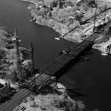
The bridge was built as part of the Connecticut Turnpike, creating a vital traffic link that has served the region for decades. It was developed to support growing transportation needs along this major interstate corridor.

The bridge takes its name from a song connected to the American Revolution, linking the region to that period of American history. The name itself serves as a reminder of Connecticut's role in the nation's founding era.

The bridge is accessible at all times and undergoes regular inspections to ensure its safety. Visitors should be aware that it is a heavily traveled route where traffic congestion can occur during peak hours.

The structure underwent major renovation work that combined repairs with broader infrastructure improvements along the corridor. These efforts demonstrate the importance of ongoing maintenance for transportation safety in the region.

The community of curious travelers

AroundUs brings together thousands of curated places, local tips, and hidden gems, enriched daily by 60,000 contributors worldwide.

Start exploring
Location
GPS coordinates
41.10750,-73.41040
Latest update
December 14, 2025 16:43
Around this place
Lockwood-Mathews Mansion
United States of America

Lockwood-Mathews Mansion

589 m
Maritime Aquarium at Norwalk
United States of America

Maritime Aquarium at Norwalk

881 m
Norwalk River Railroad Bridge
United States of America

Norwalk River Railroad Bridge

895 m
Stepping Stones Museum for Children
United States of America

Stepping Stones Museum for Children

688 m
Village Creek
United States of America

Village Creek

3.3 km
Saint Mary Church
United States of America

Saint Mary Church

882 m
Saugatuck River Bridge
United States of America

Saugatuck River Bridge

3.8 km
Beth Israel Synagogue
United States of America

Beth Israel Synagogue

1.8 km
Saugatuck River Railroad Bridge
United States of America

Saugatuck River Railroad Bridge

3.7 km
Mill Hill Historic Park
United States of America

Mill Hill Historic Park

1.1 km
Compo–Owenoke Historic District
United States of America

Compo–Owenoke Historic District

4.6 km
South Main and Washington Streets Historic District
United States of America

South Main and Washington Streets Historic District

1.1 km
Peck Ledge Light
United States of America

Peck Ledge Light

4.8 km
The Allen House
United States of America

The Allen House

3.1 km
Norwalk Green Historic District
United States of America

Norwalk Green Historic District

1.2 km
South Norwalk Railroad Bridge
United States of America

South Norwalk Railroad Bridge

1.2 km
Kayak for a Cause
United States of America

Kayak for a Cause

2.9 km
SoNo Switch Tower
United States of America

SoNo Switch Tower

1.1 km
Five Mile River Landing Historic District
United States of America

Five Mile River Landing Historic District

5 km
Wall Street Historic District
United States of America

Wall Street Historic District

1.2 km
Calf Pasture Beach
United States of America

Calf Pasture Beach

2.9 km
United States Post Office–South Norwalk Main
United States of America

United States Post Office–South Norwalk Main

1.3 km
Norwalk City Hall
United States of America

Norwalk City Hall

1.1 km
Haviland and Elizabeth Streets-Hanford Place Historic District
United States of America

Haviland and Elizabeth Streets-Hanford Place Historic District

1.4 km
SONO 50
United States of America

SONO 50

1.3 km
Enos Kellogg House
United States of America

Enos Kellogg House

4.8 km
Bridge Street Historic District
United States of America

Bridge Street Historic District

4.2 km
Manresa Institute
United States of America

Manresa Institute

3.9 km
Show the full map
Reviews
Share your experience

No review yet

Discussions
Start a discussion...

No discussion yet

« Yankee Doodle Bridge - Highway bridge in Norwalk, United States » is provided by Around Us (aroundus.com). Images and texts are derived from Wikimedia project under a Creative Commons license. You are allowed to copy, distribute, and modify copies of this page, under the conditions set by the license, as long as this note is clearly visible.

Discover hidden gems everywhere you go!

From secret cafés to breathtaking viewpoints, skip the crowded tourist spots and find places that match your style. Our app makes it easy with voice search, smart filtering, route optimization, and insider tips from travelers worldwide. Download now for the complete mobile experience.

Around Us App Screenshot

A unique approach to discovering new places

Le Figaro

All the places worth exploring

France Info

A tailor-made excursion in just a few clicks

20 Minutes

Around Us
Travel Guide & Maps
Download

Send to your phone

QR Code
1

Open the camera app on your mobile.

2

Point at the QR code with your camera. A notification will appear.

3

Tap the notification to open the link.