Enable Location

We need your location to show you interesting places around you

Discover nearby places

Find interesting locations and hidden gems around you

Precise directions

Get accurate directions and distances to places

Your location is never shared with other users. It's only used when you tap the location button.

Forest Dale Iron Furnace

Log in to your account

Start exploring — it's free

Trusted by 61,899 travelers worldwide

Continue with Google
Continue with Apple
or

We will send you a code to connect

By continuing, you accept our Terms and Conditions and our Privacy Policy

Check your inbox

We've sent a pincode in your inbox. Please enter the code below.

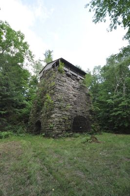
Forest Dale Iron Furnace, Blast furnace in Brandon, US

Forest Dale Iron Furnace is a stone and brick blast furnace that rises 18 meters high with three arched openings at its base. Its roughly 10-meter-square base forms the centerpiece of a historic production site.

The furnace was built in 1810 and operated until 1855 using iron ore from nearby deposits. During this time it was the center of an important local industry that produced items for everyday use and farming.

The furnace shows how iron production shaped the region during the 1800s and what role industrial craftsmanship played in the local community. The remains help visitors understand how physically demanding work and manufacturing were central to life back then.

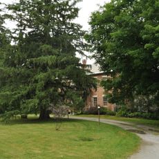
The site is located east of Forest Dale village along Vermont Route 73, marked by a historical marker. The grounds are mostly level and grassy, making them easy to walk across and explore.

The grounds contain traces of work areas and production remains that show how iron making actually happened in the 1800s. These archaeological clues reveal details about old techniques that visitors cannot see in the structure itself.

The community of curious travelers

AroundUs brings together thousands of curated places, local tips, and hidden gems, enriched daily by 60,000 contributors worldwide.

Start exploring
Location
Inception
1810
GPS coordinates
43.83194,-73.04833
Latest update
December 14, 2025 18:16
Around this place
Vermont Marble Museum
United States of America

Vermont Marble Museum

18.7 km
Robert Frost Farm
United States of America

Robert Frost Farm

15.4 km
Branbury State Park
United States of America

Branbury State Park

8.5 km
Shard Villa
United States of America

Shard Villa

14.6 km
Thomas H. Palmer House
United States of America

Thomas H. Palmer House

15 km
Cedar Swamp Covered Bridge
United States of America

Cedar Swamp Covered Bridge

14 km
Gorham Covered Bridge
United States of America

Gorham Covered Bridge

16.9 km
Cooley Covered Bridge
United States of America

Cooley Covered Bridge

15.9 km
Vermont Experimental Cold-Hardy Cactus Garden
United States of America

Vermont Experimental Cold-Hardy Cactus Garden

17.7 km
Marble Bridge
United States of America

Marble Bridge

19.1 km
Hammond Covered Bridge
United States of America

Hammond Covered Bridge

12.4 km
East Shoreham Covered Railroad Bridge
United States of America

East Shoreham Covered Railroad Bridge

17 km
Sanderson Covered Bridge
United States of America

Sanderson Covered Bridge

7 km
Middlebury Gorge Concrete Arch Bridge
United States of America

Middlebury Gorge Concrete Arch Bridge

15.7 km
Depot Covered Bridge
United States of America

Depot Covered Bridge

13.6 km
Dean Covered Bridge
United States of America

Dean Covered Bridge

7.1 km
Salisbury Town Hall
United States of America

Salisbury Town Hall

8.4 km
Salisbury Congregational Church
United States of America

Salisbury Congregational Church

8.5 km
Ruth Stone House
United States of America

Ruth Stone House

4.6 km
Colburn Bridge
United States of America

Colburn Bridge

14.1 km
Leicester Meeting House
United States of America

Leicester Meeting House

6.2 km
Pittsford Green Historic District
United States of America

Pittsford Green Historic District

14 km
Sudbury School No. 3
United States of America

Sudbury School No. 3

13.3 km
Fenn Farm
United States of America

Fenn Farm

17 km
Ripton Community House
United States of America

Ripton Community House

16 km
Salisbury Fish Hatchery
United States of America

Salisbury Fish Hatchery

11 km
School House and Town Hall
United States of America

School House and Town Hall

6.2 km
Robert Frost Interpretive Area
United States of America

Robert Frost Interpretive Area

14.3 km
Show the full map
« Forest Dale Iron Furnace - Blast furnace in Brandon, US » is provided by Around Us (aroundus.com). Images and texts are derived from Wikimedia project under a Creative Commons license. You are allowed to copy, distribute, and modify copies of this page, under the conditions set by the license, as long as this note is clearly visible.

Discover hidden gems everywhere you go!

From secret cafés to breathtaking viewpoints, skip the crowded tourist spots and find places that match your style. Our app makes it easy with voice search, smart filtering, route optimization, and insider tips from travelers worldwide. Download now for the complete mobile experience.

Around Us App Screenshot

A unique approach to discovering new places

Le Figaro

All the places worth exploring

France Info

A tailor-made excursion in just a few clicks

20 Minutes

Around Us
Travel Guide & Maps
Download

Send to your phone

QR Code
1

Open the camera app on your mobile.

2

Point at the QR code with your camera. A notification will appear.

3

Tap the notification to open the link.