Enable Location

We need your location to show you interesting places around you

Discover nearby places

Find interesting locations and hidden gems around you

Precise directions

Get accurate directions and distances to places

Your location is never shared with other users. It's only used when you tap the location button.

Log in to your account

Start exploring — it's free

Trusted by 62,473 travelers worldwide

Continue with Google
Continue with Apple
or

We will send you a code to connect

By continuing, you accept our Terms and Conditions and our Privacy Policy

Check your inbox

We've sent a pincode in your inbox. Please enter the code below.

Martha Sundquist State Forest

Martha Sundquist State Forest, State forest in Cocke County, Tennessee.

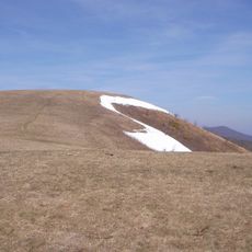
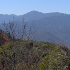
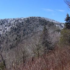
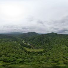
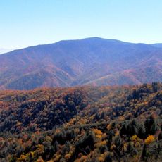
Martha Sundquist State Forest is a state forest in Cocke County covering just over 2,000 acres of mature hardwood forest on hillsides and in coves. The surrounding landscape is dominated by the Cherokee National Forest, which borders it on three sides.

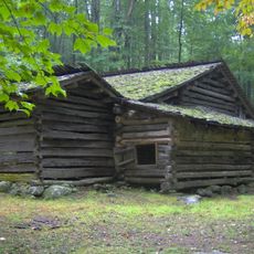
The Tennessee Division of Forestry took over this forest in 2001 from the International Paper Company, which had operated it under the name Champion International Corporation. This change marked the shift from private timber management to state ownership.

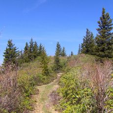
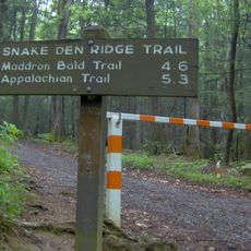
The Tennessee Gulf Trail extends 3.3 miles through the forest, connecting its northwestern and southeastern corners along Brown Gap Creek.

Access is via Gulf Road, where parking areas are located near the start of trails used for hiking, hunting, fishing, and wildlife viewing. The trails are open to multiple activities, and visitors should come prepared for changing mountain weather.

This is Tennessee's only state forest within the Blue Ridge province and contains eastern hemlock, magnolia, maple, birch, and white pine trees. The combination of these species in a state-managed forest makes the location botanically notable.

The community of curious travelers

AroundUs brings together thousands of curated places, local tips, and hidden gems, enriched daily by 60,000 contributors worldwide.

Start exploring
Location
Inception
2001
GPS coordinates
35.80000,-83.02000
Latest update
December 12, 2025 07:50
Around this place
Ghost Town in the Sky
United States of America

Ghost Town in the Sky

31.1 km
Max Patch
United States of America

Max Patch

5.7 km
Mount Guyot
United States of America

Mount Guyot

23.9 km
Forbidden Caverns
United States of America

Forbidden Caverns

31.6 km
Bush's Visitor Center
United States of America

Bush's Visitor Center

32.3 km
Old Black
United States of America

Old Black

23.3 km
United States of America

Mount Chapman

25.9 km
Tyson McCarter Place
United States of America

Tyson McCarter Place

25.9 km
Maddron Bald Trail
United States of America

Maddron Bald Trail

22.6 km
Snake Den Ridge Trail
United States of America

Snake Den Ridge Trail

18 km
Foxfire Mountain Themed Adventure Park
United States of America

Foxfire Mountain Themed Adventure Park

33.7 km
Swaggerty Blockhouse
United States of America

Swaggerty Blockhouse

24.2 km
United States of America

Lower Mount Cammerer Trail

17.5 km
Jeff White House
United States of America

Jeff White House

33.8 km
Frank Smathers House
United States of America

Frank Smathers House

32.8 km
Madison County Courthouse
United States of America

Madison County Courthouse

30.3 km
Shook-Welch-Smathers House
United States of America

Shook-Welch-Smathers House

31.2 km
Davis Family House
United States of America

Davis Family House

20.2 km
Colonial Theater
United States of America

Colonial Theater

34 km
Marshall Main Street Historic District
United States of America

Marshall Main Street Historic District

30.4 km
James H. White House
United States of America

James H. White House

30.4 km
United States of America

Mount Zion United Methodist Church

24.1 km
Shackford Hall
United States of America

Shackford Hall

30.9 km
Sunnybank
United States of America

Sunnybank

20 km
Clyde H. Ray Sr. House
United States of America

Clyde H. Ray Sr. House

33.8 km
Mount Cammerer Fire Lookout
United States of America

Mount Cammerer Fire Lookout

13.4 km
Mount Sterling Tower
United States of America

Mount Sterling Tower

14.3 km
Mount Sterling
United States of America

Mount Sterling

14.3 km
Show the full map
« Martha Sundquist State Forest - State forest in Cocke County, Tennessee » is provided by Around Us (aroundus.com). Images and texts are derived from Wikimedia project under a Creative Commons license. You are allowed to copy, distribute, and modify copies of this page, under the conditions set by the license, as long as this note is clearly visible.

Discover hidden gems everywhere you go!

From secret cafés to breathtaking viewpoints, skip the crowded tourist spots and find places that match your style. Our app makes it easy with voice search, smart filtering, route optimization, and insider tips from travelers worldwide. Download now for the complete mobile experience.

Around Us App Screenshot

A unique approach to discovering new places

Le Figaro

All the places worth exploring

France Info

A tailor-made excursion in just a few clicks

20 Minutes

Around Us
Travel Guide & Maps
Download

Send to your phone

QR Code
1

Open the camera app on your mobile.

2

Point at the QR code with your camera. A notification will appear.

3

Tap the notification to open the link.