Chest opened
+${chestReward.xp} XP
Explorer
NOUVEAU ×${chestReward.collectible.quantity}
tapez pour fermer
Chest locked

Open chests in the app

Around Us is built for your phone — chests unlock when you walk, explore and capture nearby places.

Enable Location

We need your location to show you interesting places around you

Discover nearby places

Find interesting locations and hidden gems around you

Precise directions

Get accurate directions and distances to places

Your location is never shared with other users. It's only used when you tap the location button.

Log in to your account

Start exploring — it's free

Trusted by 72,997 travelers worldwide

Continue with Google
Continue with Apple
or

We will send you a code to connect

By continuing, you accept our Terms and Conditions and our Privacy Policy

Check your inbox

We've sent a pincode in your inbox. Please enter the code below.

Hazen's Notch State Park
Discussion Reviews Photo
1.5k Popularity

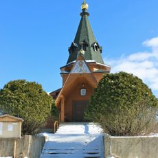
Hazen's Notch State Park, State park in Orleans County, United States.

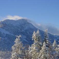
Hazen's Notch State Park is a 307-acre natural area in northern Vermont with two prominent mountain peaks, Sugarloaf Mountain and Haystack Mountain. The Long Trail runs through the park, connecting these summits and passing through diverse forest and alpine terrain.

The site marks the end of the Hazen Military Road, built in 1779 as part of an American military campaign during the Revolution. This road was one of the earliest routes cut through this remote mountain region.

The stone marker placed here in 1903 by local historians remembers the Hazen Road's endpoint, a route that still shapes how people understand the region's past.

The park offers multiple outdoor activities year-round, including hiking, bird watching, and snowshoeing depending on the season. The Long Trail provides access points at different levels of difficulty for various hiking abilities.

The park sits on rare serpentine rock formations that support unusual alpine plants found nowhere else in the region. These specialized plants thrive in the mineral-rich soil created by this distinctive geology.

The community of curious travelers

AroundUs brings together thousands of curated places, local tips, and hidden gems, enriched daily by 60,000 contributors worldwide.

Start exploring
Location
GPS coordinates
44.84440,-72.52040
Latest update
December 14, 2025 15:00
Around this place
Jay Peak
United States of America

Jay Peak

8.9 km
East Richford–Glen Sutton Border Crossing
United States of America

East Richford–Glen Sutton Border Crossing

23.7 km
Big Jay
United States of America

Big Jay

8 km
Morgan Covered Bridge
United States of America

Morgan Covered Bridge

19.9 km
Missisquoi River Bridge
Canada

Missisquoi River Bridge

19.6 km
Sweat-Comings Company House
United States of America

Sweat-Comings Company House

20.8 km
Holy Transfiguration skete
Canada

Holy Transfiguration skete

21 km
Hutchins Covered Bridge
United States of America

Hutchins Covered Bridge

7.4 km
West Hill Covered Bridge
United States of America

West Hill Covered Bridge

10.4 km
Longley Covered Bridge
United States of America

Longley Covered Bridge

12.7 km
Enosburg Congregational Memorial Church
United States of America

Enosburg Congregational Memorial Church

18.9 km
Comstock Covered Bridge
United States of America

Comstock Covered Bridge

11.5 km
Fuller Covered Bridge
United States of America

Fuller Covered Bridge

11.5 km
River Road Covered Bridge
United States of America

River Road Covered Bridge

15.9 km
Mill Covered Bridge
United States of America

Mill Covered Bridge

20.7 km
St. George's Catholic Church
United States of America

St. George's Catholic Church

23.2 km
Sheldon Boright House
United States of America

Sheldon Boright House

21 km
St. Ann's Episcopal Church
United States of America

St. Ann's Episcopal Church

20.9 km
Orne Covered Bridge
United States of America

Orne Covered Bridge

19.5 km
Hectorville Covered Bridge
United States of America

Hectorville Covered Bridge

7.4 km
Bridge 12
United States of America

Bridge 12

20.5 km
Enosburg Opera House
United States of America

Enosburg Opera House

23.4 km
Jaynes Covered Bridge
United States of America

Jaynes Covered Bridge

23.8 km
Montgomery House
United States of America

Montgomery House

11.4 km
Pont de la Frontière
Canada

Pont de la Frontière

21.9 km
F.W. Wheeler House
United States of America

F.W. Wheeler House

20.6 km
Richford Primary School
United States of America

Richford Primary School

20.9 km
Billado Block
United States of America

Billado Block

23.5 km
Show the full map
Reviews
Share your experience

No review yet

Discussions
Start a discussion...

No discussion yet

« Hazen's Notch State Park - State park in Orleans County, United States » is provided by Around Us (aroundus.com). Images and texts are derived from Wikimedia project under a Creative Commons license. You are allowed to copy, distribute, and modify copies of this page, under the conditions set by the license, as long as this note is clearly visible.

Discover hidden gems everywhere you go!

From secret cafés to breathtaking viewpoints, skip the crowded tourist spots and find places that match your style. Our app makes it easy with voice search, smart filtering, route optimization, and insider tips from travelers worldwide. Download now for the complete mobile experience.

Around Us App Screenshot

A unique approach to discovering new places

Le Figaro

All the places worth exploring

France Info

A tailor-made excursion in just a few clicks

20 Minutes

Around Us
Travel Guide & Maps
Download

Send to your phone

QR Code
1

Open the camera app on your mobile.

2

Point at the QR code with your camera. A notification will appear.

3

Tap the notification to open the link.