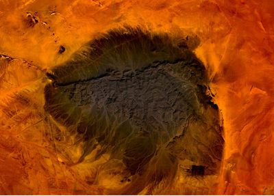
Kediet ej Jill, Summit in Tiris Zemmour region, Mauritania.
Kediet ej Jill is the highest summit in Mauritania, a freestanding rock mass rising from a flat desert plain in the Tiris Zemmour region. The mountain is made up largely of iron-rich rock, giving it a blue-gray color, and its surface shows the combined effects of natural erosion and ongoing mining activity.
French geologists identified iron ore deposits here in the 1930s, but large-scale extraction only began in 1962 under the MIFERMA company. The arrival of industrial mining brought roads, workers, and new settlements to a region that had previously been very remote.
The name Kediet ej Jill comes from Hassaniya Arabic, the local dialect spoken across much of Mauritania. For people living nearby, the mountain is closely tied to work in the mines, which shapes the rhythm of daily life in the area.
Access to the mountain is restricted because of active mining operations, so any visit requires advance coordination with local authorities and the mining company. The terrain is rough and facilities are very limited, so going with an experienced local guide is essential.
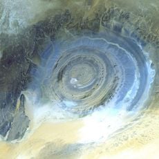
The concentration of iron in the rock is high enough to cause magnetic anomalies that can throw off a compass near the mountain. This means that travelers relying on traditional navigation tools may get misleading readings when passing close by.
The community of curious travelers
AroundUs brings together thousands of curated places, local tips, and hidden gems, enriched daily by 60,000 contributors worldwide.