Enable Location

We need your location to show you interesting places around you

Discover nearby places

Find interesting locations and hidden gems around you

Precise directions

Get accurate directions and distances to places

Your location is never shared with other users. It's only used when you tap the location button.

Cerro Batoví

Log in to your account

Start exploring — it's free

Trusted by 63,168 travelers worldwide

Continue with Google
Continue with Apple
or

We will send you a code to connect

By continuing, you accept our Terms and Conditions and our Privacy Policy

Check your inbox

We've sent a pincode in your inbox. Please enter the code below.

Cerro Batoví
Discussion Reviews 1 Photos
4.1k Popularity

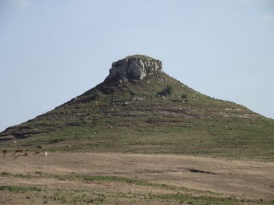
Cerro Batoví, Hill summit in Tacuarembó Department, Uruguay.

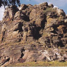
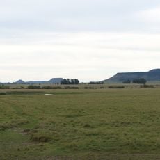
Cerro Batoví is a 224-meter-high hill in northern Uruguay with a distinctive flat top made of basaltic stone blocks formed from ancient volcanic rock. The blocky formations give the summit its characteristic appearance and define its striking profile.

The hill formed approximately 200 million years ago through volcanic activity and preserves evidence of this ancient past. Geological fossils of prehistoric llamas have been found in its rock layers, documenting the early life that once inhabited this region.

The name Batoví comes from the Guaraní language and reflects the indigenous roots of the region. Since 1960, this summit has appeared on the coat of arms of Tacuarembó Department, honoring its importance to local identity.

The summit is located at kilometer 368 on Route 5 and requires a moderate hiking trail through natural terrain and grasslands. Proper footwear and weather protection are advisable for the ascent across this open landscape.

This hill is part of Cuchilla de los Once Cerros, a group of eleven flat-topped elevations that stand isolated in the surrounding grasslands. This unusual concentration of similarly shaped mountains makes the region geologically noteworthy.

The community of curious travelers

AroundUs brings together thousands of curated places, local tips, and hidden gems, enriched daily by 60,000 contributors worldwide.

Start exploring
GPS coordinates
-31.87557,-56.01136
Latest update
December 11, 2025 11:07
Reviews
Share your experience

No review yet

Discussions
Start a discussion...

No discussion yet

« Cerro Batoví - Hill summit in Tacuarembó Department, Uruguay » is provided by Around Us (aroundus.com). Images and texts are derived from Wikimedia project under a Creative Commons license. You are allowed to copy, distribute, and modify copies of this page, under the conditions set by the license, as long as this note is clearly visible.

Discover hidden gems everywhere you go!

From secret cafés to breathtaking viewpoints, skip the crowded tourist spots and find places that match your style. Our app makes it easy with voice search, smart filtering, route optimization, and insider tips from travelers worldwide. Download now for the complete mobile experience.

Around Us App Screenshot

A unique approach to discovering new places

Le Figaro

All the places worth exploring

France Info

A tailor-made excursion in just a few clicks

20 Minutes

Around Us
Travel Guide & Maps
Download

Send to your phone

QR Code
1

Open the camera app on your mobile.

2

Point at the QR code with your camera. A notification will appear.

3

Tap the notification to open the link.