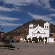
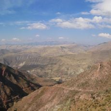
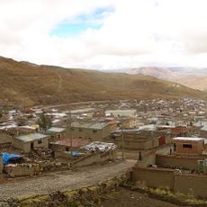
Cerro Rico, Mountain peak in Potosí region, Bolivia
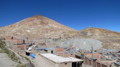
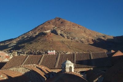
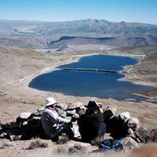
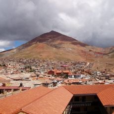
Cerro Rico is a summit near Potosí in Bolivia that rises to 4782 meters (15,689 feet) above sea level and stands out for its cone shape and reddish color. Hundreds of mine entrances dot the slopes, and in some areas you can see the different rock layers and ore veins that shape the entire relief.
Spanish conquerors discovered the silver deposits in 1545 and mined them intensively over the following centuries. Extraction accelerated in the 18th century and helped turn Potosí into one of the largest cities in the world.
The name means Rich Mountain in Spanish and refers to the enormous mineral wealth extracted here for centuries. Miners often enter the tunnels with offerings for El Tío, a figure from local belief whom they honor as a protective spirit of the underworld.
Tours into the mines require sturdy footwear, warm clothing and a headlamp, as the tunnels are dark and damp. The altitude can cause breathing difficulties, so spending a few days in Potosí beforehand to acclimatize is advisable.
In some tunnels miners work under conditions that have changed little since the 16th century, still using hand tools and dynamite. You can observe these active work areas during guided tours, offering a direct look at the daily life of the miners.
Location: Tomás Frías Province
Elevation above the sea: 4,800 m
Address: Cerro Rico, Bolivia
GPS coordinates: -19.61944,-65.74978
Latest update: December 12, 2025 17:52
Bolivia sits in the central Andes, linking mountain ranges, high plateau lands, and lowland rainforests in a landlocked country. The changes in altitude create different climate zones and landscapes, from snow-covered peaks to tropical vegetation. Many visitors start in La Paz, a city that clings to...
National Mint of Bolivia
3.5 km
La Glorieta castle
78.1 km
House of Freedom
81.8 km
Sucre Cathedral
81.7 km
Cathedral Basilica of Our Lady of Peace, Potosí
3.4 km
La Recoleta Monastery
81.7 km
Estadio Víctor Agustín Ugarte
4.7 km
San Lorenzo Church, Potosí
3.7 km
Estadio Olímpico Patria
83.3 km
Basílica de San Francisco, Sucre, Bolivia
81.9 km
Antonio José de Sucre Bridge
66.9 km
Plaza 10 de Noviembre
3.4 km
Palacio de la Prefectura de Chuquisaca
81.6 km
Inka Mach'ay, Bolivia
81.3 km
Torre de la Compañía
3.5 km
Convento de San Felipe de Neri
81.6 km
Potosí mountain range
14.1 km
National Archive and Library of Bolivia
81.7 km
Devil´s bridge
29.9 km
Pari Urqu
8.2 km
Iglesia de La Merced
81.5 km
Plaza 25 de Mayo
81.8 km
Roles Apart-Hotel
82.7 km
Templo de San Lázaro
81.9 km
Pari Chata
43.5 km
Kunturiri
12.8 km
Kuntur Nasa
44.8 km
Saint Theresa Museum
3.5 kmVisited this place? Tap the stars to rate it and share your experience / photos with the community! Try now! You can cancel it anytime.
Discover hidden gems everywhere you go!
From secret cafés to breathtaking viewpoints, skip the crowded tourist spots and find places that match your style. Our app makes it easy with voice search, smart filtering, route optimization, and insider tips from travelers worldwide. Download now for the complete mobile experience.
A unique approach to discovering new places❞
— Le Figaro
All the places worth exploring❞
— France Info
A tailor-made excursion in just a few clicks❞
— 20 Minutes