Enable Location

We need your location to show you interesting places around you

Discover nearby places

Find interesting locations and hidden gems around you

Precise directions

Get accurate directions and distances to places

Your location is never shared with other users. It's only used when you tap the location button.

Log in to your account

Start exploring — it's free

Trusted by 62,033 travelers worldwide

Continue with Google
Continue with Apple
or

We will send you a code to connect

By continuing, you accept our Terms and Conditions and our Privacy Policy

Check your inbox

We've sent a pincode in your inbox. Please enter the code below.

Sarah Baartman District Municipality, District municipality in Eastern Cape, South Africa.

Sarah Baartman District Municipality is an administrative region in Eastern Cape that encompasses seven local municipalities with towns and villages spread across the province. The area connects coastal settlements with inland communities through its territory.

This administrative region was established in 2000 as part of restructuring local governance after apartheid ended in South Africa. The creation helped establish new administrative systems across the province.

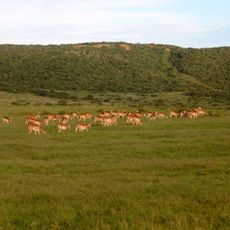
The district holds regular agricultural markets where farmers display their mohair products, as the region produces 52 percent of South Africa's total mohair.

The region is accessible through national highways that connect coastal towns like Jeffreys Bay with inland communities. Visitors will find road connections linking the various local municipalities together.

The region has a strong tradition in mohair production, where local farmers work with this valued textile material. The Sundays River Valley also plays a role in the area's agricultural operations with specific crop cultivation.

The community of curious travelers

AroundUs brings together thousands of curated places, local tips, and hidden gems, enriched daily by 60,000 contributors worldwide.

Start exploring
Location
Inception
December 5, 2000
Capital city
Gqeberha
Elevation above the sea
476 m
Shares border with
Garden Route District Municipality, Central Karoo District Municipality, Pixley ka Seme District Municipality
GPS coordinates
-33.95000,25.60000
Latest update
December 7, 2025 19:25
« Sarah Baartman District Municipality - District municipality in Eastern Cape, South Africa » is provided by Around Us (aroundus.com). Images and texts are derived from Wikimedia project under a Creative Commons license. You are allowed to copy, distribute, and modify copies of this page, under the conditions set by the license, as long as this note is clearly visible.

Discover hidden gems everywhere you go!

From secret cafés to breathtaking viewpoints, skip the crowded tourist spots and find places that match your style. Our app makes it easy with voice search, smart filtering, route optimization, and insider tips from travelers worldwide. Download now for the complete mobile experience.

Around Us App Screenshot

A unique approach to discovering new places

Le Figaro

All the places worth exploring

France Info

A tailor-made excursion in just a few clicks

20 Minutes

Around Us
Travel Guide & Maps
Download

Send to your phone

QR Code
1

Open the camera app on your mobile.

2

Point at the QR code with your camera. A notification will appear.

3

Tap the notification to open the link.