Inch Clutha, River island in Clutha District, New Zealand.
Inch Clutha is a river island in the Clutha District situated between two branches of the Clutha River and connected to the mainland by bridges. The island spans a considerable length and is characterized by pastureland and farmland.
The island formed in 1878 when a major flood altered the Clutha River's course, diverting it from its previous outlet at Port Molyneux. This natural event fundamentally reshaped the landscape of the region.
The name blends Scottish roots with local geography: 'innis' means island in Scots Gaelic, while 'Clutha' comes from Cluaidh, the Gaelic name for River Clyde. This naming reflects the region's historical connections to Scotland.
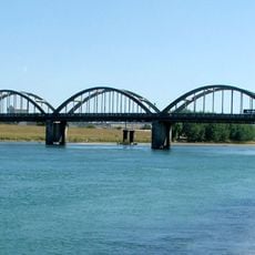
Two bridges along the Kaitangata Highway provide straightforward access to the island from the mainland. The location between two towns makes it easy to visit as part of a broader route.
Along the southwestern edge of the island lie several oxbow lakes formed where earlier river curves once meandered. At one point the land narrows to just a few dozen meters, revealing how continuously the river shapes the landscape.
The community of curious travelers
AroundUs brings together thousands of curated places, local tips, and hidden gems, enriched daily by 60,000 contributors worldwide.